Scattered Showers & Storms Today; No Help From Humberto

We do have a lower-level trough near the I-59 corridor that will be a focal point for the formation of scattered showers and thunderstorms during the heating of the day today. We’ll take what we can get as this will be the best rain chance we’ll get for at least the next six days. Rain chances will range from 20%-50% across the area with the higher chances along the I-59 corridor down to a line from Demopolis to Clanton to Alexander City. Highs will top out in the lower to mid-90s across the area. Coverage will start to diminish through the evening and late-night hours, with all activity coming to an end around midnight. Lows will be in the upper 60s to the mid-70s.
Sunday will be a mostly sunny and mainly dry day as subsidence from Humberto starts to move in from the east. There may be an isolated shower or two over the extreme southern parts of the area during the afternoon, but those chances are so small that I almost didn’t mention it. Highs will be in the lower to mid-90s.
On Monday, Humberto starts to move eastward away from the Southeastern US Atlantic Coast. We continue to have hot and dry conditions across Central Alabama. We’ll have plenty of sunshine and highs in the mid to upper 90s.
On Tuesday, Humberto accelerates eastward away from the coast. For Central Alabama, we continue to stay hot and dry with highs reaching the upper 90s to just over 100 degrees across the area. Much of the same story on Wednesday… we’ll be hot with plenty of sunshine throughout the day. Afternoon highs will be in the 90s across the area.
On Thursday, we’ll have high pressure starting to build off to our northeast that will bring a little cooler air in from the east and some clouds. We will stay dry but afternoon highs will only be in the upper 80s to the lower 90s across the area.
Friday will be another fantastic but dry day as the high builds and continues to send in cooler air. We’ll have plenty of sunshine with highs in the upper 80s to just over 90 degrees across the area.
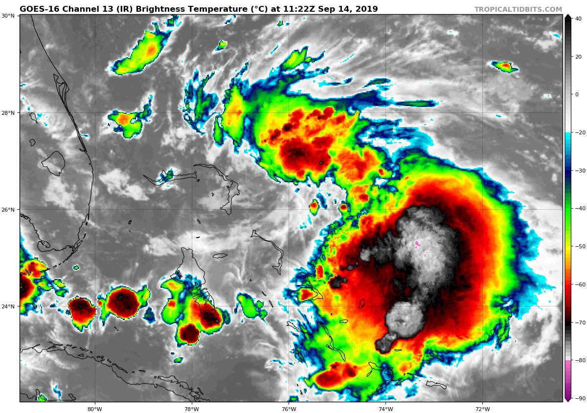
Here is the look at Humberto at 6:40 this morning. As of the 4:00 am update, Humberto’s winds were at 40 MPH and were moving to the northwest at 7 MPH.
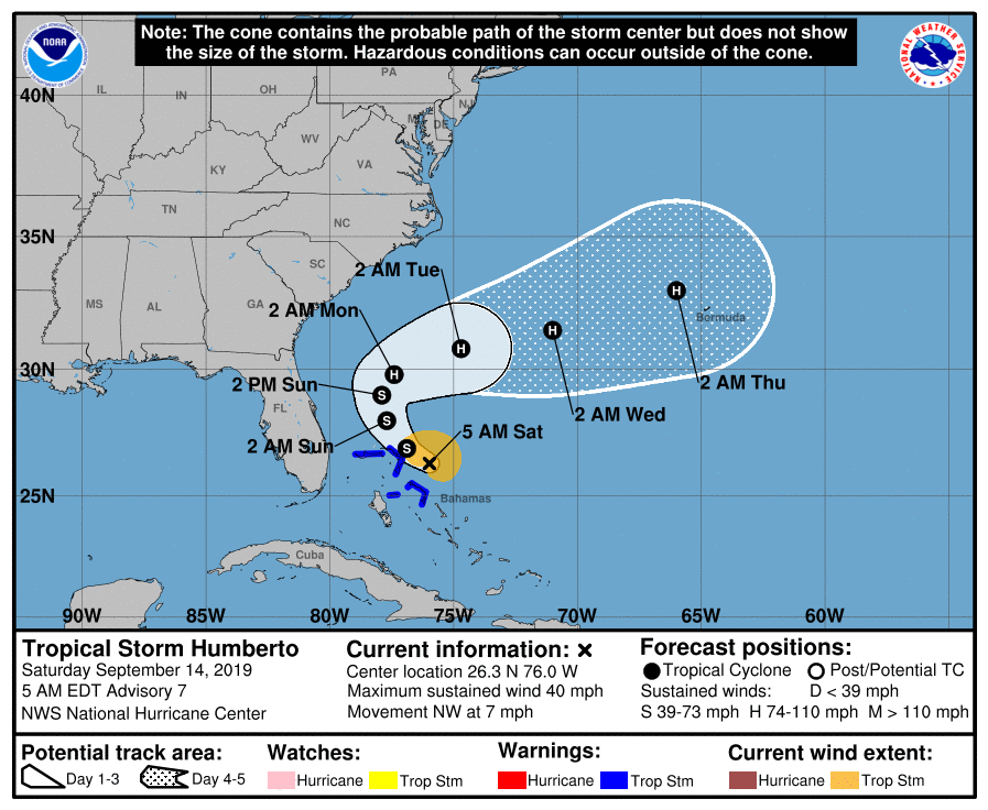
The latest forecast track shows that the center of Humberto will stay well off the coast and eventually turn out to sea by early Tuesday. Much of the heavier rain will stay over the ocean which should keep any flooding threat off the map for the coast. The main threat to the southeastern coast will be from rough seas and rip currents. Wind may be breezy at times with occasional gusts up to tropical-storm-force, but the odds of sustained winds above 39 MPH along the coast look small at this point.
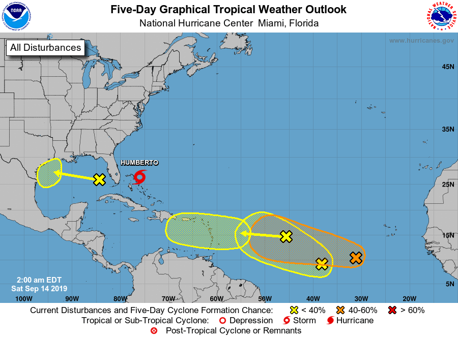
We also have four other hotspots that we will need to watch over the next several days. The closest to home is a disturbance over the eastern Gulf of Mexico. Some slow development may occur as it moves west-northwestward toward the Texas coast, but the National Hurricane Center is only giving it a 20% chance of developing into a depression over the next five days.
The next is a tropical wave located around 1000 miles east of the Lesser Antilles. Some slow development could occur over the next few days as it races off to the west, but is only given a 20% of becoming a depression over the next five days.
The next potential depression is located around 600 miles to the southwest of the Cabo Verde Islands. Gradual development is expected over the next few days and it has a 60% chance of becoming a depression over the next five days.
The last disturbance is located between the last two tropical waves that I have already mentioned. There is a possibility that it may merge with the tropical wave approaching from the east, but some development is possible if the merge does not occur. At this point, it is only given a 20% chance of developing into a depression within the next five days.
Category: Alabama's Weather, ALL POSTS, Tropical, Weather Xtreme Videos
About the Author (Author Profile)
Scott Martin is an operational meteorologist, professional graphic artist, musician, husband, and father. Not only is Scott a member of the National Weather Association, but he is also the Central Alabama Chapter of the NWA president. Scott is also the co-founder of Racecast Weather, which provides forecasts for many racing series across the USA. He also supplies forecasts for the BassMaster Elite Series events including the BassMaster Classic.Subscribe
If you enjoyed this article, subscribe to receive more just like it.


