

Hot Afternoon, Watching for Scattered Storms
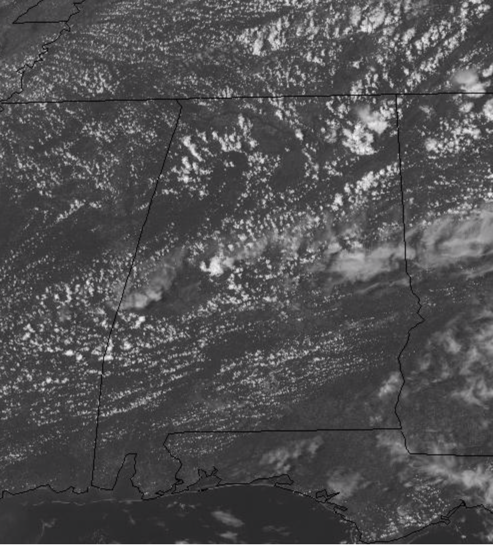
Through the morning hours, we have seen mainly sunny conditions and that has allowed our temperatures to warm up fast and early this afternoon we are seeing them return to the 90s. Highs today should reach the mid and upper 90s again, but we do have better rain chances today across much of Central Alabama. Through the late afternoon evening hours, the radar should get active with scattered showers and storms as a weakness in the ridge and an area of higher moisture content across the state will allow for this convection. Not everyone will see rain today, but we all know, that where storms develop this afternoon, they will be producing gusty winds, heavy rainfall, and lots of lightning. The activity should continue through the early night hours, before gradually winding down after midnight. Lows tonight should fall back into the lower 70s in most spots.
HOT & DRIER SUNDAY: Tomorrow will feature more sun than clouds and once again afternoon temperatures will surge well into the 90s through the afternoon hours, as many locations will once again see highs in the mid to perhaps upper 90s. Rain chances are much lower tomorrow, but not zero, and we should see a few, random, afternoon storms across the Alabama landscape, but these will be few and far between.
VERY HOT AND MAINLY DRY WEEK AHEAD: With Humberto staying well to the east of the area, we are not going to be getting any heat relief from this system in the form of rain. If anything, sinking air around the system means our rain chances will actually fall to near zero, and highs will once again climb higher. The first half the week looks to feature more blistering heat for all of Alabama as we are expecting highs once again in the upper 90s to near 100°. There certainly could be a random afternoon storm somewhere, but I wouldn’t count on it; I would count on more record highs for many locations Monday, Tuesday, and perhaps Wednesday. By the end of the week, it looks like the ridge finally begins to break down, which would at least allow for temps to fall back into the lower 90s for afternoon highs, which are still well above average for this time of year. Unfortunately, the next 7-10 days, there is just know real signs of beneficial rains for Alabama, and with the very hot temperatures, drought conditions are going to be getting worse.
TROPICAL STORM HUMBERTO: At 1100 AM EDT, the center of Tropical Storm Humberto was located by an Air Force Hurricane Hunter plane near latitude 26.6 North, longitude 76.7 West. Humberto has been nearly stationary during the past few hours, but the cyclone should resume a slow motion toward the northwest and north later today. A sharp turn to the northeast is expected on Monday. On the forecast track, the center of Humberto should gradually move away from the northwestern Bahamas later today or tonight, and then will move well offshore of the east coast of Florida this weekend and early next week.
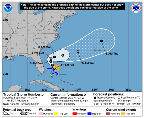
Maximum sustained winds have increased to near 50 mph with higher gusts. Humberto is forecast to become a hurricane by Sunday night well east of the east coast of Florida. Tropical-storm-force winds extend outward up to 90 miles to the north and east of the center. The minimum central pressure from a reconnaissance plane was 1005mb (29.68 inches).
REST OF TROPICS: Well we are in the heart of hurricane season, so you’d expect there to be several areas of interest to watch, and that is what we have today…
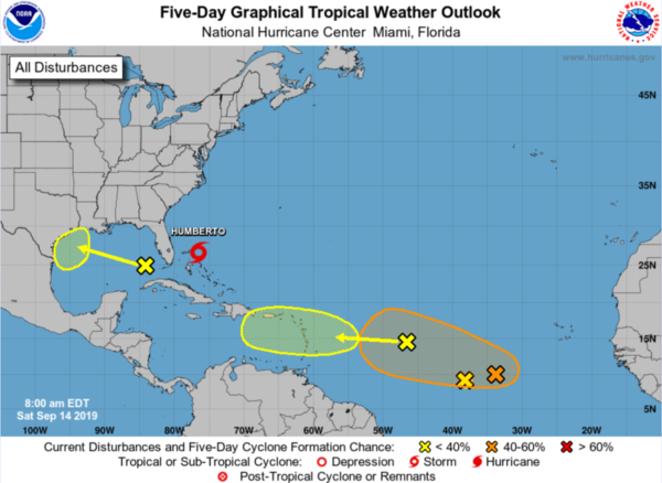
1. A fast-moving tropical wave is located about 950 miles east of the Lesser Antilles. This system is producing limited shower activity, and significant development of this system is not anticipated during the next several days while it moves quickly westward. Formation chance through 5 days…low…10 percent.
2. An elongated area of disturbed weather is located about 650 miles southwest of the Cabo Verde Islands. Gradual development of this system is possible during the next several days, and a tropical depression could form early next week while it moves westward across the tropical Atlantic. Formation chance through 48 hours…low…20 percent. Formation chance through 5 days…medium…60 percent.
3. The area of disturbed weather that was located midway between the Lesser Antilles and the Cabo Verde Islands has merged with the easternmost tropical wave mentioned above. Development of the original disturbance is no longer anticipated. Formation chance through 5 days…low…near 0 percent.
4. A large area of showers and thunderstorms over the eastern Gulf of Mexico is primarily associated with a upper-level low pressure area. Only slow development of this system is likely during the next couple of days. However, conditions could become more conducive for development early next week as the system moves over the western Gulf of Mexico. Formation chance through 48 hours…low…near 10 percent. Formation chance through 5 days…low…30 percent.
BEACH FORECAST CENTER: Get the latest weather and rip current forecasts for the beaches from Fort Morgan to Panama City on our Beach Forecast Center page. There, you can select the forecast of the region that you are interested in visiting.
WORLD TEMPERATURE EXTREMES: Over the last 24 hours, the highest observation outside the U.S. was 117.1F at Failakah Island, Kuwait. The lowest observation was -105.0F at Vostok, Antarctica.
CONTIGUOUS TEMPERATURE EXTREMES: The highest observation was 113F at Death Valley, CA. The lowest observation was 22F at Harbison Meadow, CA.
WEATHER ON THIS DATE IN 1944: A very destructive hurricane swept across Cape Hatteras and Chesapeake Bay, side swiped New Jersey and Long Island, and crossed southeastern Massachusetts. The hurricane killed more than four hundred persons, mainly at sea. The hurricane destroyed the Atlantic City, NJ boardwalk.
Category: Alabama's Weather, ALL POSTS
About the Author (Author Profile)
Macon, Georgia Television Chief Meteorologist, Birmingham native, and long time Contributor on AlabamaWX. Stormchaser. I did not choose Weather, it chose Me. College Football Fanatic. @Ryan_StinnetSubscribe
If you enjoyed this article, subscribe to receive more just like it.


