

Humberto Forecast To Become A Hurricane By Late Sunday Or Early Monday

As of the 1:00 pm update from the National Hurricane Center, Tropical Storm Humberto has begun to move again to the northwest at 7 MPH. Winds continue to be at 50 MPH and pressure is at 1005 MB. Latest forecast track from the NCH has Humberto becoming a hurricane by late Sunday or early Monday. Here is the latest intermediate advisory from the NHC:
HUMBERTO CRAWLING NORTHWESTWARD; FORECAST TO BECOME A HURRICANE BY SUNDAY NIGHT OR EARLY MONDAY.
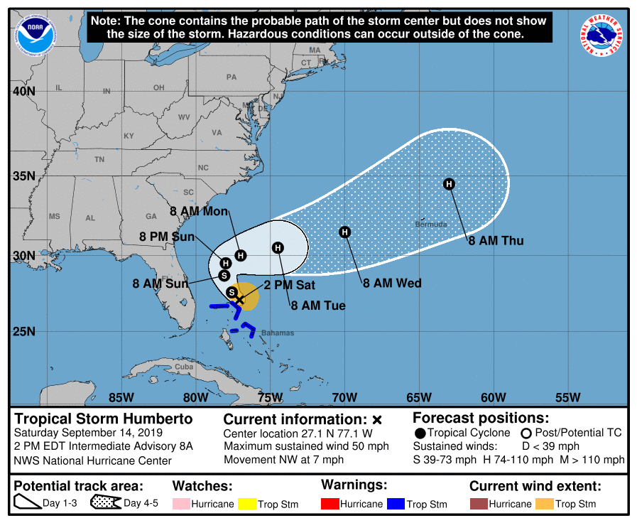
LOCATION…27.1N 77.1W
ABOUT 40 MI…65 KM N OF GREAT ABACO ISLAND
ABOUT 120 MI…190 KM ENE OF FREEPORT GRAND BAHAMA ISLAND
MAXIMUM SUSTAINED WINDS…50 MPH…85 KM/H
PRESENT MOVEMENT…NW OR 315 DEGREES AT 7 MPH…11 KM/H
MINIMUM CENTRAL PRESSURE…1005 MB…29.68 INCHES
WATCHES AND WARNINGS
A Tropical Storm Warning is in effect for…
* Northwestern Bahamas excluding Andros Island
DISCUSSION AND OUTLOOK
At 200 PM EDT (1800 UTC), the center of Tropical Storm Humberto was located by an Air Force Hurricane Hunter plane near latitude 27.1 North, longitude 77.1 West. After several hours meandering, Humberto has begun to move toward the northwest at 7 mph (11 km/h), and this general motion with a gradual turn to the north is expected during the next day or so. A sharp turn to the northeast is expected on Monday. On the forecast track, the center of Humberto should gradually move away from the northwestern Bahamas today or tonight, and then move well offshore of the east coast of Florida this weekend and early next week.
Maximum sustained winds are near 50 mph (85 km/h) with higher gusts. Humberto is forecast to become a hurricane by Sunday night well east of the east coast of Florida.
Tropical-storm-force winds extend outward up to 90 miles (150 km) to the north and east of the center.
The latest minimum central pressure just reported by a reconnaissance plane was 1005 MB (29.68 inches).
HAZARDS AFFECTING LAND
WIND: Tropical storm conditions are still expected within portions of the warning area in the northwestern Bahamas today. These winds should subside later today or tonight.
RAINFALL: Humberto is expected to produce the following total rainfall accumulations through Monday:
The Bahamas…Additional 1 to 3 inches, isolated storm totals of 6 inches.
Portions of the Florida and Georgia coasts…up to 1 inch.
STORM SURGE: Humberto is not expected to produce significant storm surge in the northwestern Bahamas.
SURF: Swells generated by Humberto are expected to increase and affect the coast from east-central Florida to South Carolina late this weekend and early next week. These swells could cause life-threatening surf and rip current conditions. Please consult products from your local weather office.
About the Author (Author Profile)
Scott Martin is an operational meteorologist, professional graphic artist, musician, husband, and father. Not only is Scott a member of the National Weather Association, but he is also the Central Alabama Chapter of the NWA president. Scott is also the co-founder of Racecast Weather, which provides forecasts for many racing series across the USA. He also supplies forecasts for the BassMaster Elite Series events including the BassMaster Classic.Subscribe
If you enjoyed this article, subscribe to receive more just like it.


