Sunday Morning Update on Humberto: Storm Strengthening, Expected to Become Hurricane Tonight
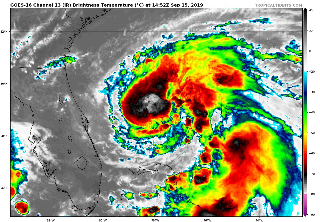
Humberto is starting to look better organized on satellite imagery this morning.
Conditions are favorable for some strengthening, and the storm is expected to become a hurricane late tonight.
The Air Force plane went back to Keesler after being in the area for only a short time so we don’t have any recent central pressure measurements.
Humberto will continue turning northeast into a weakness being created by the upper-level trough over the eastern United States.
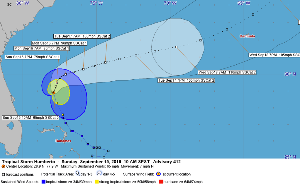
The forecast track carries it close to Bermuda late Wednesday as a category two hurricane with top winds around 105 mph. Bermuda could feel the affect of hurricane-force winds.
It will have no impact on the U.S. except for an increased risk for rip currents along southeastern coastal areas.
Here is the full advisory:
…HUMBERTO STRENGTHENING AND EXPECTED TO BECOME A HURRICANE BY
TONIGHT…
…SWELLS FROM HUMBERTO WILL INCREASE RIP CURRENT THREAT ALONG THE
SOUTHEASTERN UNITED STATES COAST…
SUMMARY OF 1100 AM EDT…1500 UTC…INFORMATION
———————————————–
LOCATION…28.9N 77.9W
ABOUT 180 MI…290 KM NNW OF GREAT ABACO ISLAND
ABOUT 165 MI…270 KM ENE OF CAPE CANAVERAL FLORIDA
MAXIMUM SUSTAINED WINDS…65 MPH…100 KM/H
PRESENT MOVEMENT…N OR 350 DEGREES AT 7 MPH…11 KM/H
MINIMUM CENTRAL PRESSURE…997 MB…29.44 INCHES
WATCHES AND WARNINGS
——————–
There are no coastal watches or warnings in effect.
DISCUSSION AND OUTLOOK
———————-
At 1100 AM EDT (1500 UTC), the center of Tropical Storm Humberto was
located near latitude 28.9 North, longitude 77.9 West. Humberto is
moving toward the north near 7 mph (11 km/h), and this motion is
expected to continue into tonight. A sharp turn to the northeast is
forecast to occur Monday morning or afternoon, followed by a motion
toward the northeast and east-northeast on Tuesday and Wednesday. On
the forecast track, the center of Humberto will continue to move
away from the Bahamas and remain well offshore of the east coast of
Florida through Wednesday.
Maximum sustained winds have increased to near 65 mph (100 km/h)
with higher gusts. Additional strengthening is forecast through
Wednesday, and Humberto is expected to become a hurricane by
tonight.
Tropical-storm-force winds extend outward up to 160 miles (260 km)
from the center.
The estimated minimum central pressure is 997 mb (29.44 inches).
HAZARDS AFFECTING LAND
———————-
WIND: Gusty winds in squalls are still affecting portions of the
northwestern Bahamas. These winds should subside later today.
RAINFALL: Outer rain bands associated with Humberto are expected
to produce additional rainfall of 1 to 2 inches in the central and
northern Bahamas, with isolated storm total amounts of 6 inches.
Humberto may bring periods of heavy rain to Bermuda beginning late
Wednesday.
SURF: Swells generated by Humberto will affect the northwestern
Bahamas, and the southeastern coast of the United States from
east-central Florida to North Carolina during the next few days.
These swells could cause life-threatening surf and rip current
conditions. Please consult products from your local weather
office.
NEXT ADVISORY
————-
Next complete advisory at 500 PM EDT.
About the Author (Author Profile)
Bill Murray is the President of The Weather Factory. He is the site's official weather historian and a weekend forecaster. He also anchors the site's severe weather coverage. Bill Murray is the proud holder of National Weather Association Digital Seal #0001 @wxhistorianSubscribe
If you enjoyed this article, subscribe to receive more just like it.


