Dry Weather Continues; Lower Heat Levels By Thursday
WE NEED RAIN: Birmingham’s rain total for the month of September so far is only 0.56”… and we have recorded measurable rain on only two days (September 11 and 14). Our last good soaking came on August 26/27, when the two day total was 2.72”. The deficit for the year is right at two inches (-1.98”).
Unfortunately, prospects for meaningful rain look very low for at least the next seven days, so drought conditions will intensity over East Alabama, and develop over the western side of the state.
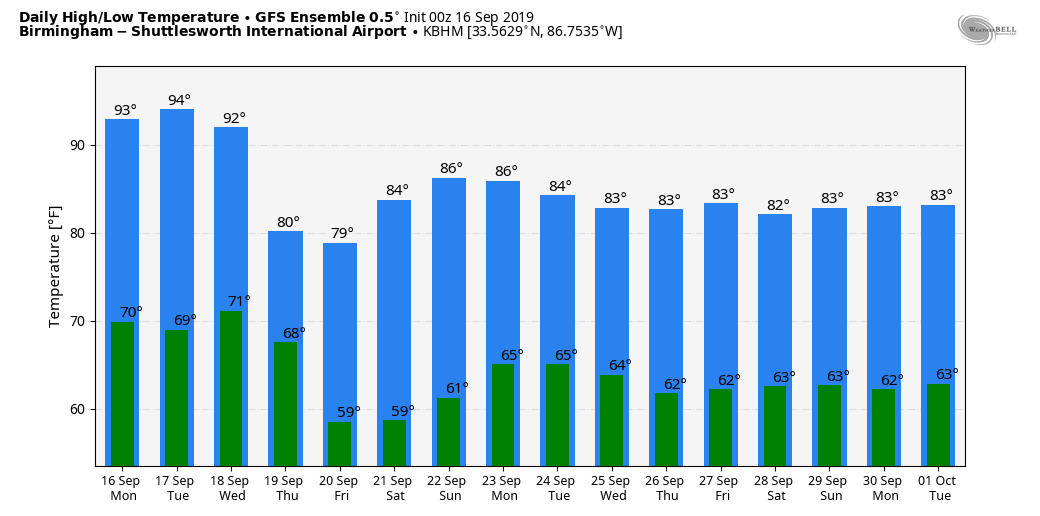
And, the weather will remain hot through Wednesday as a strong upper ridge holds with highs well up in the 90s. But, a “backdoor” cold front will pass through Wednesday evening, and bring a 10-12 degree temperature drop by Thursday and Friday, when highs go back into the mid to upper 80s.
THE ALABAMA WEEKEND: No real change; a very dry airmass remains in place, so we expect sunny days and fair nights over the weekend with highs generally between 87 and 90 degrees.
NEXT WEEK: Still no sign of rain, at least for the first half of the week. Keep in mind, in terms of climatology, September and October are the two driest months of the year in Alabama. Our average rain for September at Birmingham (1900-2018) is 3.76″, and only 2.88″ for October. Having long dry spells this time of the year is not completely unusual.
One more note… as you look at computer model temperature forecasts (model output statistics, or MOS), you will need to add several degrees to the forecast highs due to the lack of soil moisture. See the Weather Xtreme video for maps, graphics, and more details.
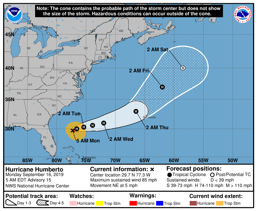
TROPICS: Hurricane Humberto, with maximum sustained winds of 85 mph, is just off the southeast coast of the U.S.. and will move east/northeast in coming days. It is expected to pass just north of Bermuda Thursday morning before becoming post-tropical in the North Atlantic Friday night.
A disturbance over the western Gulf of Mexico is forecast to moving into Texas without development over the next 24 hours. And, a wave between the coast of Africa and the Lesser Antilles has a high chance of becoming a tropical depression or storm within the next few days, but it will turn north, and head out into the North Atlantic. No threat to the U.S.
ON THIS DATE IN 2004: At 51 minutes after midnight on 16 September 2004, the northern eyewall of powerful Hurricane Ivan moved onto land near Gulf Shores as an upper Category 3 hurricane. The official time of landfall was 2:02 AM CDT. Bringing with it 130 mph surface winds and an historic storm surge, preliminary estimates show that the magnitude and extent of the damage and destruction over Baldwin County and Escambia and Santa Rosa counties of Northwest Florida likely exceeded that of both Hurricane Frederic (September 1979) and Hurricane Opal (October 1995). Additionally, Hurricane Ivan was very close to the magnitude of damage and destruction caused by the Hurricane of 1926 which ravaged the aforementioned counties east of Mobile Bay. Hurricane Ivan caused a preliminary total of 13 deaths in the following counties combined: Baldwin County, Alabama, Escambia County, Florida, Santa Rosa County, Florida. Damage over 5 billion dollars.
Ivan produced estimated maximum winds of 60 to 80 mph generally southwest of line from Prattville to Livingston. A few spots may have reached 90 mph in this area. Most other locations across central alabama had estimated maximum wind speeds of 50 to 60 mph, with a few isolated spots reaching 75 mph. Damage was severe well inland… some of the hardest hit communities included Atmore, Brewton, Evergreen, Monroeville, Camden, and Demopolis.
BEACH FORECAST: Click here to see the AlabamaWx Beach Forecast Center page.
WEATHER BRAINS: Don’t forget you can listen to our weekly 90 minute show anytime on your favorite podcast app. This is the show all about weather featuring many familiar voices, including our meteorologists here at ABC 33/40.
CONNECT: You can find me on all of the major social networks…
Facebook
Twitter
Instagram
Pinterest
Snapchat: spannwx
I have a weather program this morning at Center Point Elementary School… look for the next Weather Xtreme video here by 4:00 this afternoon. Enjoy the day!
Category: Alabama's Weather, ALL POSTS, Weather Xtreme Videos
About the Author (Author Profile)
James Spann is one of the most recognized and trusted television meteorologists in the industry. He holds the AMS CCM designation and television seals from the AMS and NWA. He is a past winner of the Broadcast Meteorologist of the Year from both professional organizations.Subscribe
If you enjoyed this article, subscribe to receive more just like it.


