Humberto Continues To Get Better Organized West Of Bermuda
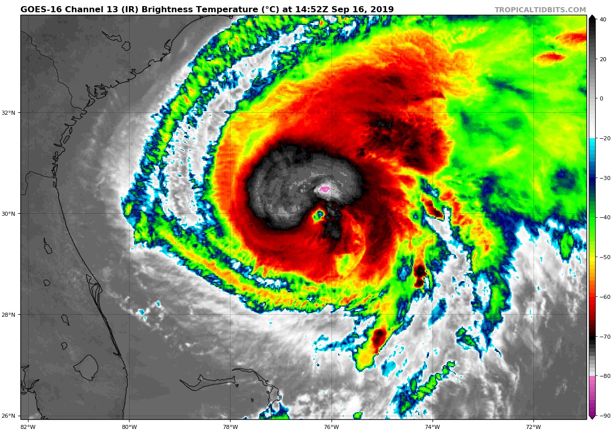
An Air Force Reserve reconnaissance aircraft investigating Humberto this morning found peak 850-mb flight-level winds of 88 kt in the southeastern and northeastern quadrants, along with SFMR surface winds of 72-73 kt in the northeastern quadrant and a minimum pressure of 978 mb. These data support an intensity of 75 kt.
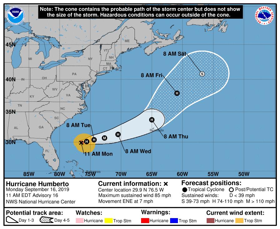
The initial motion estimate is east-northeastward or 070/06 kt. Humberto is now solidly located north of the Bermuda-Azores ridge axis, and a continued east-northeastward motion is expected for the 48 hours or so. Thereafter, a large deep-layer trough is forecast to dig southward out of Atlantic Canada and the Canadian Maritimes to the west of Humberto, forcing the hurricane to gradually lift out to the northeast. The exact timing that the trough begins to affect Humberto’s motion will be critical in determining how close the hurricane will come to Bermuda. The latest model guidance is in better agreement and more tightly packed than previous runs, suggesting that the poleward turn will occur at least 100 n mi west of the island. By days 4 and 5, however, the model guidance becomes strongly divergent with a large spread of about 1000 n mi on day 5, resulting in lower-than-normal confidence in the track forecast on those days. The new NHC track foreast was nudged only slightly southward through 48 hours, and lies close to a blend of the consensus models TVCN, NOAA-HCCA, and FSSE.
Humberto has been strengthening at a rate of 20 kt per 24 hours since this time yesterday, and that trend is expected to continue for the next day or so given the warm water beneath the hurricane and a continued favorable upper-level outflow pattern. The hurricane is expected to peak as a major hurricane in 36-48 hours when the cyclone will be located over SSTs of about 29 deg C and moving into the right-rear quadrant of a strong upper-level jet maximum. Thereafter, strong southwesterly vertical wind shear is expected to gradually diminish convection around the center despite the impressive baroclinic/dynamically driven pressure falls, which will mainly act to spread out the surface wind field rather than intensify the cyclone. Humberto is forecast to interact with an approaching cold front on day 5, resulting in extratropical transition over the colder Atlantic waters north of the Gulf Stream. The official intensity forecast is just an update of the previous advisory and now shows Humberto reaching major hurricane status, similar to the HCCA, FSSE, and HWRF models. Since Humberto’s wind field is expected to expand significantly by day 2, a Tropical Storm Watch for Bermuda will likely be required on the 500 pm EDT advisory.
Large swells from Humberto will affect portions of the northwestern Bahamas and southeastern United States coast during the next few days. These swells are expected to produce dangerous surf conditions and life-threatening rip currents.
About the Author (Author Profile)
Scott Martin is an operational meteorologist, professional graphic artist, musician, husband, and father. Not only is Scott a member of the National Weather Association, but he is also the Central Alabama Chapter of the NWA president. Scott is also the co-founder of Racecast Weather, which provides forecasts for many racing series across the USA. He also supplies forecasts for the BassMaster Elite Series events including the BassMaster Classic.Subscribe
If you enjoyed this article, subscribe to receive more just like it.


