Tropical Storm Jerry Strengthens Over The Tropical Atlantic Ocean
SUMMARY & FORECAST DISCUSSION AT 10:00 AM CT
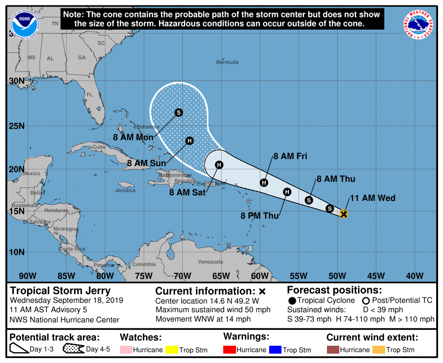
LOCATION…14.6N 49.2W
ABOUT 855 MI…1375 KM E OF THE LEEWARD ISLANDS
MAXIMUM SUSTAINED WINDS…50 MPH…85 KM/H
PRESENT MOVEMENT…WNW OR 290 DEGREES AT 14 MPH…22 KM/H
MINIMUM CENTRAL PRESSURE…1002 MB…29.59 INCHES
Satellite images indicate that Jerry continues to become better organized, with a large curved band wrapping around the center. While microwave data does not show an inner core yet, the overall satellite presentation has improved during the past several hours. The initial wind speed is set to 45 kt, which closely matches almost all of the available Dvorak estimates and a just-arrived ASCAT-C scatterometer pass.
Further intensification of Jerry is expected during the next day or two as the cyclone moves over very warm waters within light shear. While this type of environment could support even more strengthening than forecast, there is some substantial dry air around the cyclone, which is forecast to limit the intensification rates for now. This forecast leans heavier on the regional hurricane models HWRF, HMON and COAMPS-TC, which all show a weaker cyclone than the statistical/dynamical LGEM and SHIPS models. Most of the guidance shows increasing shear in a couple of days, and the shear could become somewhat strong by next week. While little change in strength is indicated beyond Friday, this usually doesn’t happen in reality, and further changes will be necessary as the environmental factors become more clear.
The initial motion continues to be west-northwestward, or 290/12 kt. The subtropical ridge to the north should steer Jerry at a faster forward speed for the next couple of days. Afterward, a northwest to north-northwestward turn, influenced by a weakness in the aforementioned ridge left behind by Humberto, is expected. The NHC track forecast is basically an update from the previous advisory and lies on the left side of the guidance suite, nearest the ECMWF model and the corrected-consensus forecasts.
Key Messages:
1. Jerry is expected to strengthen and be a hurricane when it moves near the northern Leeward Islands Friday, although it is too soon to determine the direct impacts to the islands. Interests there should ensure they have their hurricane plan in place and monitor the progress of this system. Watches could be issued for a portion of this area this afternoon or evening.
About the Author (Author Profile)
Scott Martin is an operational meteorologist, professional graphic artist, musician, husband, and father. Not only is Scott a member of the National Weather Association, but he is also the Central Alabama Chapter of the NWA president. Scott is also the co-founder of Racecast Weather, which provides forecasts for many racing series across the USA. He also supplies forecasts for the BassMaster Elite Series events including the BassMaster Classic.Subscribe
If you enjoyed this article, subscribe to receive more just like it.


