Jerry Is Now A Hurricane
SUMMARY OF 10:00 AM CT
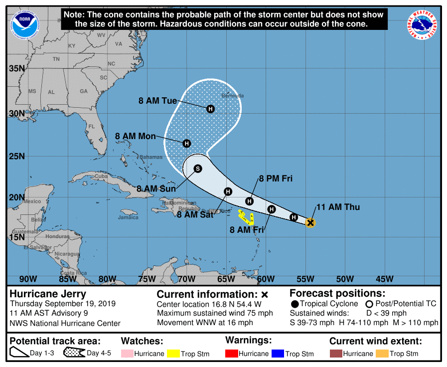
LOCATION…16.8N 54.4W
ABOUT 490 MI…785 KM E OF THE LEEWARD ISLANDS
MAXIMUM SUSTAINED WINDS…75 MPH…120 KM/H
PRESENT MOVEMENT…WNW OR 295 DEGREES AT 16 MPH…26 KM/H
MINIMUM CENTRAL PRESSURE…988 MB…29.18 INCHES
A Tropical Storm Watch is in effect for Barbuda, Anguilla, St. Maarten, St. Martin, St. Barthelemy, Saba, and St. Eustatius.

Satellite images indicate that the center of Jerry is on the northwestern side of the central dense overcast near a very deep convective burst. An Air Force recon plane just flew through the center and found a central pressure of 988 mb and SFMR values near 65 kt. These data support making Jerry the 4th hurricane of the 2019 Atlantic hurricane season with initial wind speed of 65 kt.
Jerry has the potential to further strengthen today, but an increase in northwesterly shear related to an upper-level ridge is anticipated overnight. This change in shear will likely arrest the development of Jerry and start a slow weakening trend sometime tomorrow. In 3 or 4 days, Jerry could enter a more conducive environment for strengthening, but there is a pretty large spread in the shear forecast near the cyclone at this time, related to the positioning of Jerry relative to the ridge. Since the environmental uncertainty at long range is so high, little change has been made to the previous forecast.
The initial motion is estimated to be west-northwestward, or 295/14 kt. The track forecast has remained rather consistent during the past several cycles, taking Jerry just north of the Leeward Islands during the first couple of days due to seemingly reliable steering flow from the subtropical ridge to the north. The track is a little trickier beyond that time due to some dependence on the strength of Jerry, with a stronger system likely moving a bit longer toward the west-northwest, similar to the latest ECMWF/HWRF forecast. Regardless, the cyclone should eventually turn northward and northeastward by day 5 due to a substantial break in the subtropical ridge. The track forecast puts slightly greater weight on those stronger solutions, and the official track forecast is a little left of the various consensus aids and not too far from the last NHC prediction.
Key Messages: Although the core of Jerry is expected to pass north of northern Leeward Islands, tropical-storm-force winds and locally heavy rainfall are possible, and tropical storm watches are in effect.
About the Author (Author Profile)
Scott Martin is an operational meteorologist, professional graphic artist, musician, husband, and father. Not only is Scott a member of the National Weather Association, but he is also the Central Alabama Chapter of the NWA president. Scott is also the co-founder of Racecast Weather, which provides forecasts for many racing series across the USA. He also supplies forecasts for the BassMaster Elite Series events including the BassMaster Classic.Subscribe
If you enjoyed this article, subscribe to receive more just like it.


