What A Difference The Wedge Makes At Midday
Conditions Across Central Alabama At 11:20 am
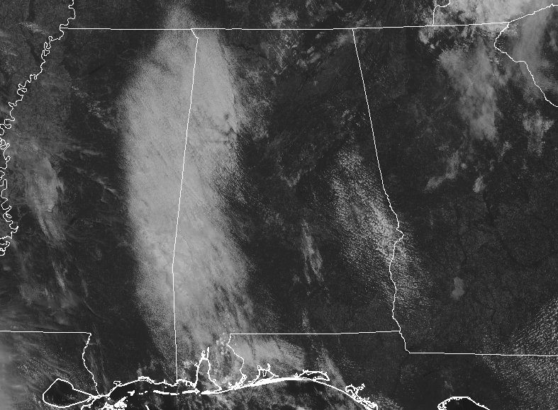
While we do have some clouds over the western parts of the area and crossing over into Mississippi, along with some scattered fair-weather clouds over the southeastern parts of the area, the rest of Central Alabama is enjoying plenty of sunshine. The best news is the temperatures at this point as we are seeing upper 70s to the mid-80s across the area. Birmingham was at 82 degrees while the warm spots were Uniontown and Selma at 86 degrees. The cool spot was Haleyville at 77 degrees.
Weather For The Rest Of Your Thursday
Drier and cooler air will continue to move in from the northeast, but close to the boundary in the southwest corner of the area, we could see a couple of isolated showers and storms. Skies will be mostly sunny to partly cloudy with afternoon highs reaching the mid-80s to the lower 90s.
Great Weather To End Off The Work Week
After starting off the morning with mainly clear skies and temperatures down in the 60s across the area, Friday will turn out to be a nearly picture-perfect day. We’ll have plenty of sunshine with highs topping out in the mid to upper 80s throughout the area. For those Friday night high school games, temperatures will start off in the lower to mid-80s at 6:00 pm and drop into the upper 60s to the mid-70s by 10:00 pm. Overnight lows will drop into the lower to mid-60s. A few of the colder locations will probably be in the upper 50s for a short amount of time.
Remnants of Imelda Continue To Bring Life-Threatening Flash Flooding Across Southeast Texas
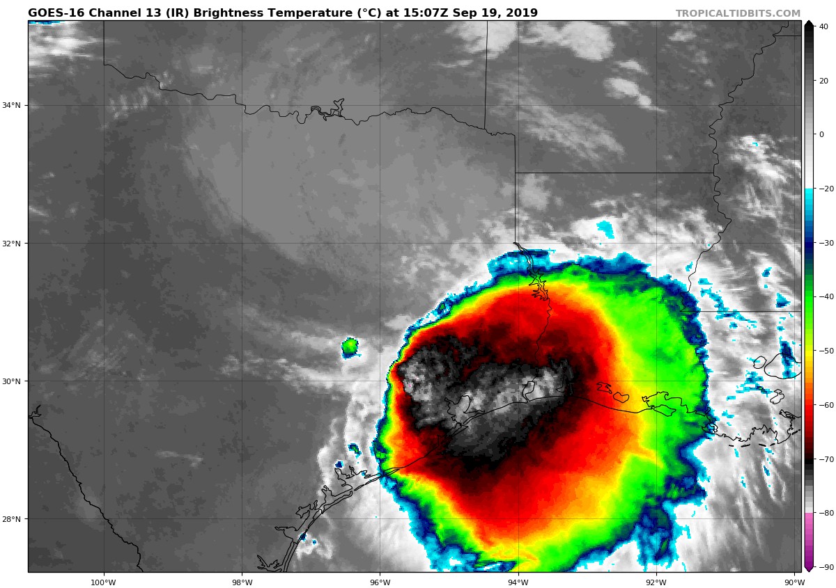
The remnants of Imelda continue to bring heavy rain and life-threatening flash flooding to southeast Texas. Houston and points south will experience rain rates at 4-6 inches per hour. Houston residents have been urged to stay put and do not travel. Schools should shelter in place and parents should not attempt to venture out in floodwaters to pick up children.
Imelda is forecast to continue on a north to north-northwest track over the next few days bring tropical rain to eastern Texas, eastern and east-central Oklahoma, and western parts of Louisiana and Arkansas. No moisture from Imelda will sneak over to Alabama to give us much needed rainfall.
Humberto Forecast to Become a Powerful Extratropical Cyclone Later Today
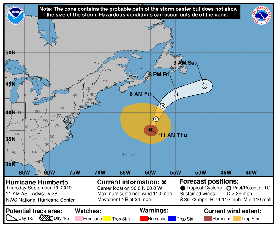
Humberto is in the process of transitioning into an extratropical hurricane as it continues to move away from Bermuda and heading out to open waters. Maximum sustained winds were still at 110 MPH and movement is to the northeast at 24 MPH. Large swells will continue to affect Bermuda, the northwestern Bahamas, and the east coast of the United States from east-central Florida to the Mid-Atlantic States during the next couple of days. These swells could create life-threatening surf and rip current conditions.
Jerry Has Been Upgraded To A Hurricane
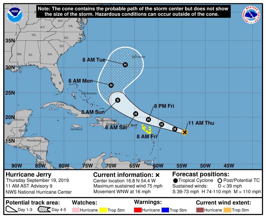
At the 10:00 am update from the National Hurricane Center, Jerry was upgraded to a hurricane as maximum sustained winds have now been clocked at 75 MPH. Jerry’s movement is to the west-northwest at 16 MPH and should stay on that general track until Sunday morning when a sharp turn to the northeast is expected. Although the center of Jerry is expected to pass north of northern Leeward Islands, tropical-storm-force winds and locally heavy rainfall are possible, and tropical storm watches are in effect.
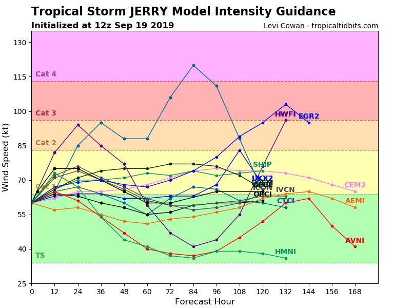
Most of the ensemble members keep Jerry as a low to mid-level category 1 hurricane through the next 168 hours (7 days), but there are a couple of outliers that ramp it up to category 2 to category 4 strength. While that is unlikely, it is not impossible. Bermuda just put up with tropical-storm and hurricane-force conditions late yesterday and early this morning from Humberto, but now lies in the center of the cone for Jerry. Let’s hope that it curves more to the east and stays away from the island.
Category: Alabama's Weather, ALL POSTS, Tropical
About the Author (Author Profile)
Scott Martin is an operational meteorologist, professional graphic artist, musician, husband, and father. Not only is Scott a member of the National Weather Association, but he is also the Central Alabama Chapter of the NWA president. Scott is also the co-founder of Racecast Weather, which provides forecasts for many racing series across the USA. He also supplies forecasts for the BassMaster Elite Series events including the BassMaster Classic.Subscribe
If you enjoyed this article, subscribe to receive more just like it.


