Karen Slowly Strengthening
SUMMARY OF 100 PM CDT
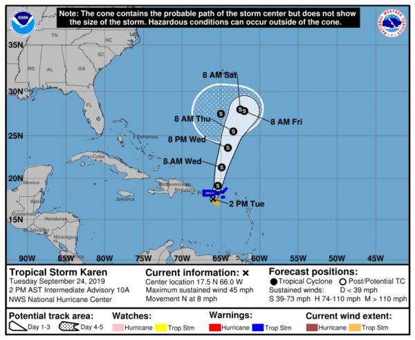
LOCATION…17.5N 66.0W
ABOUT 65 MI…105 KM S OF SAN JUAN PUERTO RICO
ABOUT 80 MI…130 KM W OF ST. CROIX
MAXIMUM SUSTAINED WINDS…45 MPH…70 KM/H
PRESENT MOVEMENT…N OR 0 DEGREES AT 8 MPH…13 KM/H
MINIMUM CENTRAL PRESSURE…1005 MB…29.68 INCHES
Tropical Storm Warnings are up for the U.S. Virgin Islands, Puerto Rico, including Vieques and Culebra, and the British Virgin Islands.
At 200 PM AST (1800 UTC), the center of Tropical Storm Karen was located near latitude 17.5 North, longitude 66.0 West. Karen has moved erratically during the past few hours as the center has re-formed a little to the west. However, it is expected to resume a motion toward the north near 8 mph (13 km/h) this afternoon. A north-northeastward motion with some increase in forward speed is forecast tonight through Wednesday night. On the forecast track, the center of Karen will pass near or over Puerto Rico and the Virgin Islands this afternoon and then move over the western Atlantic tonight and Wednesday.
Reports from an Air Force Reserve Hurricane Hunter aircraft indicate that maximum sustained winds are now near 45 mph (70 km/h) with higher gusts. Additional slow strengthening is expected during the next couple of days.
Tropical-storm-force winds extend outward up to 80 miles (130 km) mainly to the southeast of the center. Surface observations indicate that wind gusts to tropical-storm-force are occurring over portions of the Virgin Islands and southeastern Puerto Rico.
The minimum central pressure estimated from Air Force Reserve Hurricane Hunter aircraft data and surface observations is 1005 MB (29.68 inches).
HAZARDS AFFECTING LAND
RAINFALL: Karen is expected to produce the following rainfall accumulations through Wednesday…
Puerto Rico and the Virgin Islands: 2 to 4 inches, isolated 8 inches. Leeward Islands: 1 to 3 inches, isolated 5 inches. These rains may cause flash flooding and mudslides, especially in mountainous areas.
WIND: Tropical-storm-force winds, especially in gusts, are currently spreading across the warning area. Winds could be higher on the windward sides of hills and mountains, and also in elevated terrain.


