Karen Continues To Bring Heavy Rain To Puerto Rico & The Virgin Islands
SUMMARY OF 1000 PM CDT INFORMATION
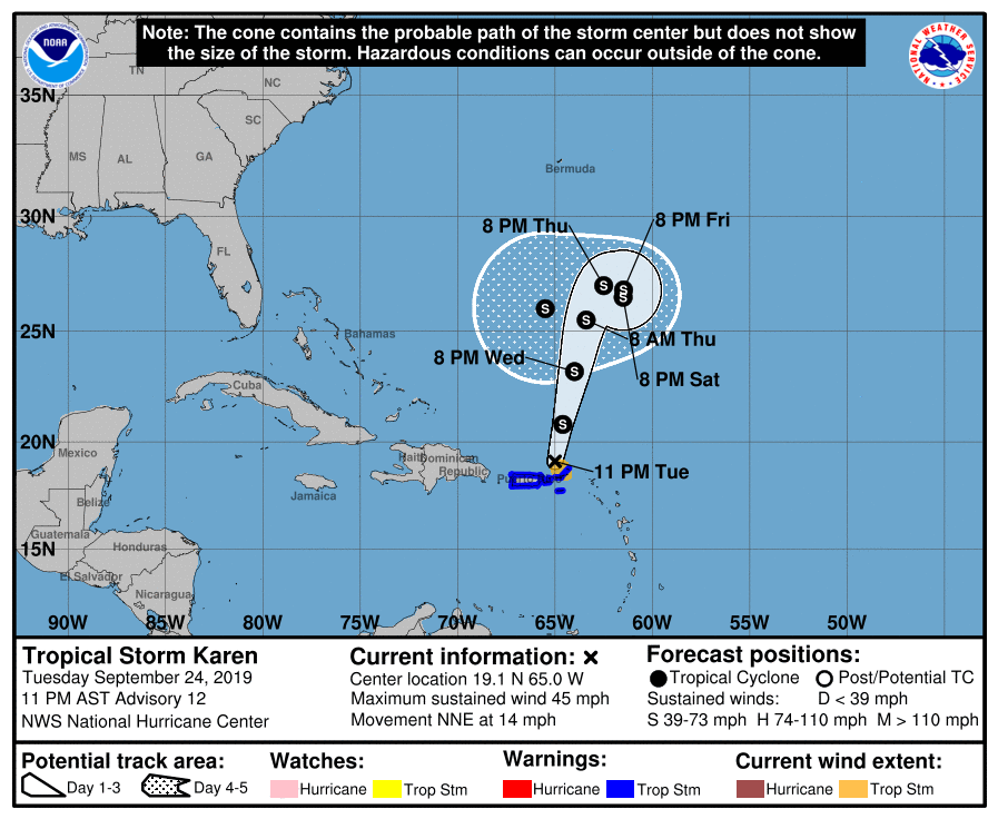
LOCATION…19.1N 65.0W
ABOUT 85 MI…140 KM NE OF SAN JUAN PUERTO RICO
ABOUT 50 MI…80 KM N OF ST. THOMAS
MAXIMUM SUSTAINED WINDS…45 MPH…75 KM/H
PRESENT MOVEMENT…NNE OR 15 DEGREES AT 14 MPH…22 KM/H
MINIMUM CENTRAL PRESSURE…1002 MB…29.59 INCHES
Tropical Storm Warnings continue for the U.S. Virgin Islands, Puerto Rico, including Vieques and Culebra, and the British Virgin Islands.
During the afternoon and early evening hours, satellite images indicated that the cloud pattern associated with Karen was becoming a little better organized. Then, surface observations from the area just east of Puerto Rico indicated that the pressures were falling, and a center was apparently becoming better defined. The presence of this center was confirmed by a reconnaissance plane which was able to fix a tight small circulation of about 1002 or 1003 MB. This, by no means, indicates that the overall circulation of the cyclone is well organized. Winds are still swirly on the western portion of the circulation and are responding to an elongated trough of low-pressure north of Puerto Rico. In fact, I would not be surprised if another center reforms father to west within the trough or the large cyclonic envelope, and the center we are tracking dissipates. In any case, preliminary analysis indicates that the center of Karen that we were tracking moved very near or over Vieques around 2100 UTC and then over Culebra a little bit later. This small center could also have been a meso-vortex within the larger circulation.
Data from the reconnaissance plane and satellite intensity estimates yield an initial intensity of 40 kt. These winds are occurring primarily to the southeast of the center. Karen is heading toward a shear environment that is not ideal at all for significant intensification. As previously indicated, the NHC forecast calls for a very modest increase in intensity during the next 3 to 5 days as indicated by the HCCA model. However, some of the statistical guidance brings Karen to hurricane status by the end of the forecast period.
Satellite and reconnaissance fixes indicate that Karen is moving toward the north-northeast or 015 degrees at 12 kt. This motion, however, is highly uncertain because it includes the reformation of the center. The circulation of Karen is trapped between a subtropical high over the Atlantic and a mid-level trough over the Bahamas. This flow pattern will continue to steer Karen in this same general direction for the next 3 days. After that time, the steering flow is forecast to collapse, and Karen, if it is still a cyclone, will begin to meander. This would allow another ridge to develop north of the cyclone and force it to move westward. This is the solution provided by most of the global models.
Key Messages: Karen will continue to bring heavy rainfall, flash floods, and mudslides to Puerto Rico, Vieques and the U.S. and the British Virgin Islands into Wednesday even as the center moves away from the region.
About the Author (Author Profile)
Scott Martin is an operational meteorologist, professional graphic artist, musician, husband, and father. Not only is Scott a member of the National Weather Association, but he is also the Central Alabama Chapter of the NWA president. Scott is also the co-founder of Racecast Weather, which provides forecasts for many racing series across the USA. He also supplies forecasts for the BassMaster Elite Series events including the BassMaster Classic.Subscribe
If you enjoyed this article, subscribe to receive more just like it.


