Jerry Continues On A Weakening Trend
SUMMARY OF 1000 PM CDT INFORMATION
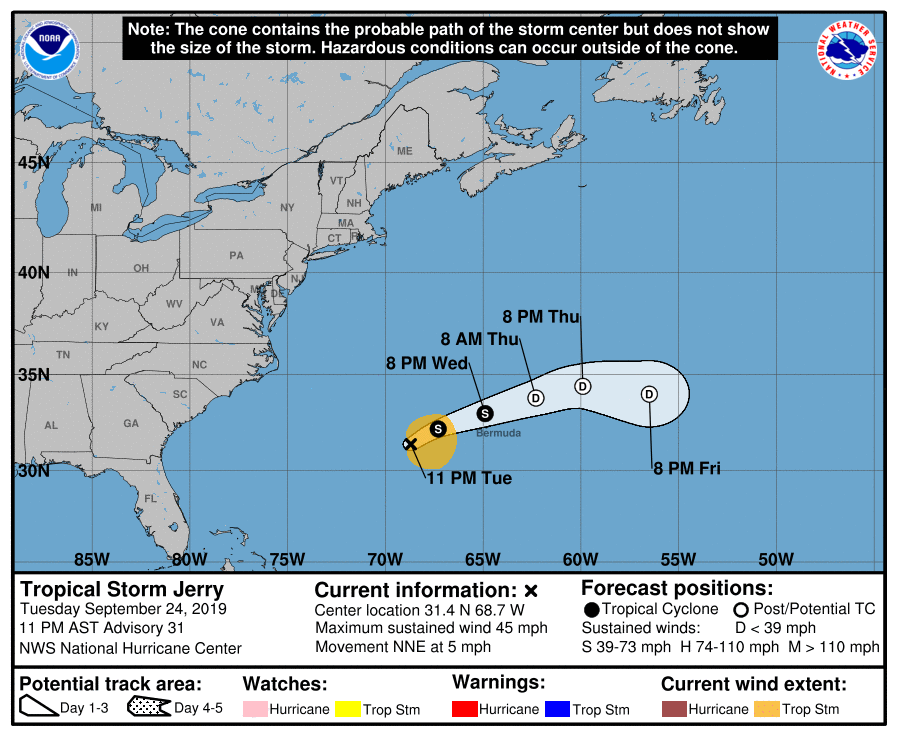
LOCATION…31.4N 68.7W
ABOUT 235 MI…380 KM WSW OF BERMUDA
MAXIMUM SUSTAINED WINDS…45 MPH…75 KM/H
PRESENT MOVEMENT…NNE OR 25 DEGREES AT 5 MPH…7 KM/H
MINIMUM CENTRAL PRESSURE…996 MB…29.42 INCHES
A Tropical Storm Warning continues for Bermuda.
Dry air and shear have continued to take a toll on Jerry, and the cyclone has been devoid of deep convection for about 12 hours. An Air Force reconnaissance aircraft that has been in the storm this evening measured peak flight-level winds of 43 kt, and SFMR winds of 34 to 36 kt. The aircraft has not sampled the entire circulation yet, so the initial intensity has been lowered, perhaps conservatively, to 40 kt. Increasing shear and dry air that is being entrained into the circulation from the west are likely to continue to contribute to Jerry’s gradual spin down over the next couple of days. If deep convection does not return overnight, Jerry could become a post-tropical cyclone as early as tomorrow morning. Regardless of the status of the system, it still has the potential to bring tropical-storm-force winds to Bermuda and advisories would continue as long as the Tropical Storm Warning is needed for that island. The global models completely dissipate Jerry in a little more than 3 days, and so does the new NHC forecast.
Jerry has turned northeastward but continues to move very slowly, or 025/4 kt. The cyclone should pick up its pace tonight and Wednesday as a broad trough passes to the north and the system gets caught within the southern edge of the mid-latitude westerlies. As Jerry get increasingly weaker it is forecast to again slow down and turn southeastward before dissipation occurs. The official track forecast is not very different than the previous advisory and is closest to the TCVN multi-model consensus.
Key Messages: Tropical-storm-force winds are expected on Bermuda beginning on Wednesday. Large swells are also expected to affect the coast of Bermuda during the next few days. These swells could cause life-threatening rip currents.
About the Author (Author Profile)
Scott Martin is an operational meteorologist, professional graphic artist, musician, husband, and father. Not only is Scott a member of the National Weather Association, but he is also the Central Alabama Chapter of the NWA president. Scott is also the co-founder of Racecast Weather, which provides forecasts for many racing series across the USA. He also supplies forecasts for the BassMaster Elite Series events including the BassMaster Classic.Subscribe
If you enjoyed this article, subscribe to receive more just like it.


