Lorenzo Resumes Intensifying; Expected To Be A Hurricane On Wednesday
SUMMARY OF 1000 PM CDT INFORMATION
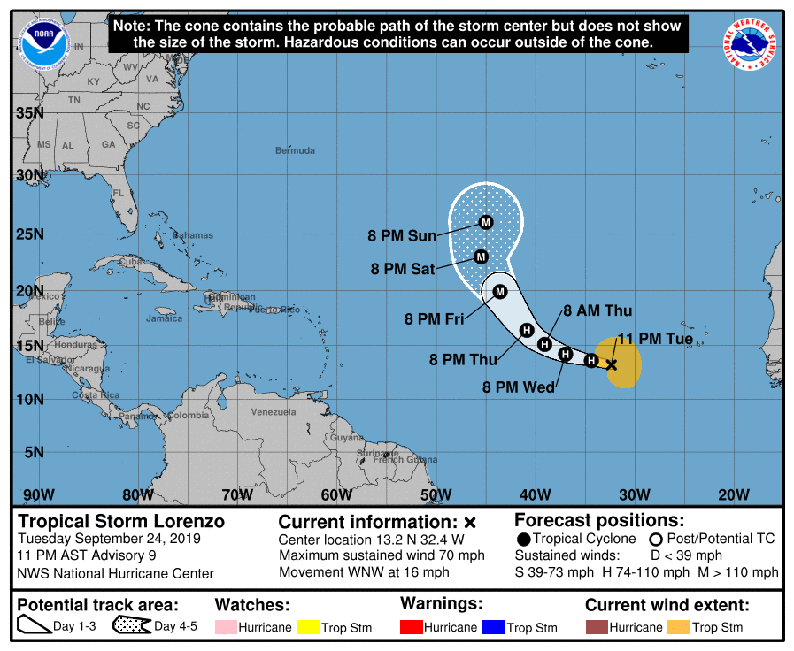
LOCATION…13.2N 32.4W
ABOUT 545 MI…880 KM W OF THE SOUTHERNMOST CABO VERDE ISLANDS
MAXIMUM SUSTAINED WINDS…70 MPH…110 KM/H
PRESENT MOVEMENT…WNW OR 285 DEGREES AT 16 MPH…26 KM/H
MINIMUM CENTRAL PRESSURE…993 MB…29.33 INCHES
Over the past several hours, deep convection has increased in coverage and intensity near Lorenzo’s center, with cloud tops now as cold as -85 degrees Celsius. Some modest northwesterly shear impacted the cyclone starting early today and lasted through this evening, but now Lorenzo seems to be overcoming the shear. The initial intensity has been increased to 60 kt and this is a blend of the latest subjective Dvorak estimates from TAFB and SAB. Recent scatterometer passes show that the wind radii have continued to expand, with tropical-storm-force winds now reaching up to 180 n mi from the center.
Lorenzo is moving west-northwestward at 14 kt to the south of a mid-level ridge. A break in the ridge is forecast to develop between 40-50W in a few days, which should cause the cyclone to turn to the northwest. By late in the forecast period, Lorenzo will turn to the north as it rounds the western periphery of the ridge. This forecast track scenario is in very good agreement with the numerical models, and little change was made from the previous official forecast.
The shear that has been occurring over Lorenzo is expected to decrease through Wednesday and based on the current convective trend, strengthening appears likely over the next couple of days. Dynamical and statistical models are in good agreement on bringing Lorenzo to hurricane intensity by Wednesday morning, and then continuing some gradual strengthening through 72 hours. After that time, the dynamical model intensity forecasts diverge from the statistical model forecasts. SHIPS and LGEM suggest that Lorenzo will reach its peak intensity in about 3 or 4 days, and weakening is possible by day 5. The dynamical models disagree with this scenario, and the consensus of those models makes Lorenzo a major hurricane in about 72 hours, with additional strengthening possible through the end of the forecast period. The official forecast is more in line with the dynamical guidance, although it is not as high as some of those solutions late in the period. Due to the divergence in model intensity forecasts beyond 72 hours, the confidence in the official forecast at that time is not high.
About the Author (Author Profile)
Scott Martin is an operational meteorologist, professional graphic artist, musician, husband, and father. Not only is Scott a member of the National Weather Association, but he is also the Central Alabama Chapter of the NWA president. Scott is also the co-founder of Racecast Weather, which provides forecasts for many racing series across the USA. He also supplies forecasts for the BassMaster Elite Series events including the BassMaster Classic.Subscribe
If you enjoyed this article, subscribe to receive more just like it.


