Extremely Powerful Lorenzo Strengthens A Little More
SUMMARY OF 1000 PM CDT INFORMATION
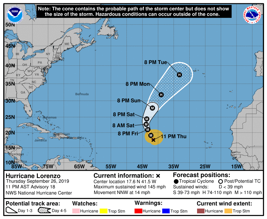
LOCATION…17.6N 41.5W
ABOUT 1660 MI…2670 KM SW OF THE AZORES
MAXIMUM SUSTAINED WINDS…145 MPH…230 KM/H
PRESENT MOVEMENT…NNW OR 330 DEGREES AT 14 MPH…22 KM/H
MINIMUM CENTRAL PRESSURE…939 MB…27.73 INCHES
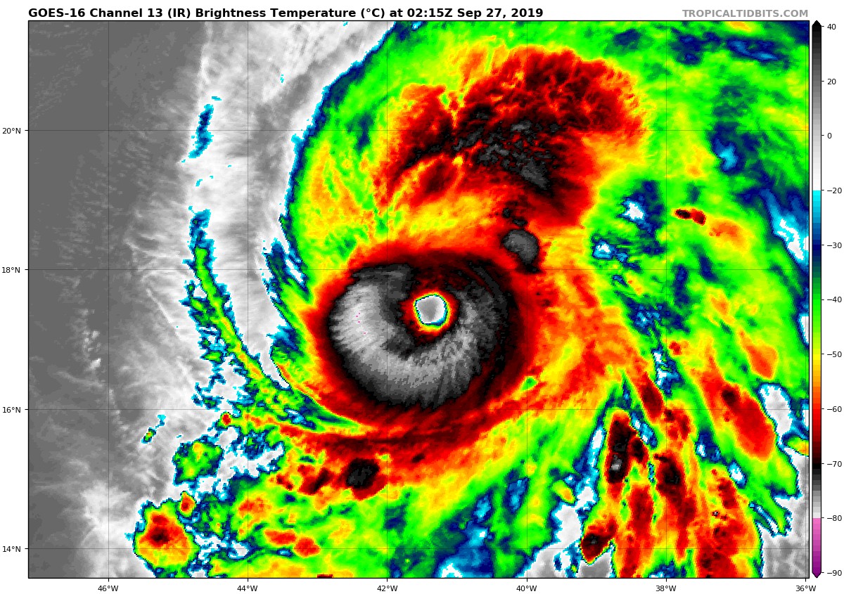
Lorenzo has intensified even more this evening, with a clear eye characterized by warm temperatures of up to 17 degrees Celsius. The eye is now completely surrounded by a ring of convection with cold cloud tops less than minus 70 degrees Celsius. The subjective Dvorak intensity estimates from both TAFB and SAB, as well as the objective intensity estimate from UW-CIMSS ADT unanimously support increasing the initial intensity to 125 kt. Lorenzo is a very large hurricane, with tropical-storm-force winds extending over 200 n mi from the center in the northern semicircle, and a cirrus cloud canopy that spans greater than a 10-degree latitude by 10-degree longitude area.
The initial motion is now north-northwest or 330/12 kt. Model guidance is in very good agreement throughout the 5 day period on the future track of Lorenzo. The hurricane will move through a break in the subtropical ridge currently to its northwest over the next couple of days, gradually turning to the north then northeast as it rounds the periphery of a ridge to its east. Late in the forecast period, Lorenzo will begin to accelerate as it gets caught in the southwesterly flow ahead of an approaching mid-latitude trough. The model guidance made a slight shift to the left since the previous advisory, but since the same guidance shifted right earlier today, I did not want to make much of a change to the track. The official forecast track is very near the previous one and is now on the right side of the consensus guidance.
The environment around Lorenzo is expected to change little over the next day or so. Both dynamical and statistical guidance is suggesting that the hurricane is nearing peak intensity. Therefore only fluctuations in strength due to eyewall replacement cycles are expected through about Friday night. Over the weekend, some moderate westerly shear ahead of the approaching mid-latitude trough could begin to slowly weaken the cyclone. Late in the forecast period, the combination of strong upper-level southwesterly winds and cooler sea surface temperatures should cause a faster weakening trend. The official forecast is essentially an update of the previous one and a little higher than most of the guidance through the first 48 hours.
About the Author (Author Profile)
Scott Martin is an operational meteorologist, professional graphic artist, musician, husband, and father. Not only is Scott a member of the National Weather Association, but he is also the Central Alabama Chapter of the NWA president. Scott is also the co-founder of Racecast Weather, which provides forecasts for many racing series across the USA. He also supplies forecasts for the BassMaster Elite Series events including the BassMaster Classic.Subscribe
If you enjoyed this article, subscribe to receive more just like it.


