

Cloudy & Cool Thanks To PTC-16 At Midday
CONDITIONS AT MIDDAY

At 12:00 pm, we have a good bit of cloud cover across nearly all of Central Alabama from the northern fringes of PTC-16. Temperatures across the area are being held down thanks to the clouds keeping the sunlight from reaching the surface. We are seeing the upper 50s to the mid-60s showing up on the reporting stations at this time. Birmingham was at 61 degrees. The cool spot was Demopolis at 56 degrees. Anniston was the warm spot at 64 degrees. Radar is free from any rainfall at this time.
WEATHER FOR THE REST OF YOUR FRIDAY

Clouds will be on the increase throughout the remainder of the afternoon hours across Central Alabama with the approach of PTC-16 to the Gulf Coast. We’ll stay dry and afternoon highs will reach the upper 60s to the lower 70s across the area.
Much of the evening and night time hours should be dry tonight before the outer rain bands start moving into the southern and southeastern parts of Central Alabama as we approach midnight. We’ll keep a small chance of showers in the forecast before the end of the high school football games in those locations while the rest of the games across the area will remain dry. Temperatures will start off in themid to upper 60s at kickoff and fall into the mid-50s to the lower 60s by the final whistle.
During the overnight hours, rain chances will start to increase from the south and southeast at the outer rain bands of PTC-16 start to move in across the area. Locations north of the I-59 corridor should remain dry through sunrise, while south of that, rain chances greatly increase as you move southward (20% to 50% north of the I-85 corridor, 60% to 100% south of that). Lows will be in the lower 50s to the lower 60s.
WE’LL SEE SOME MINOR IMPACTS FROM PTC-16 ON SATURDAY
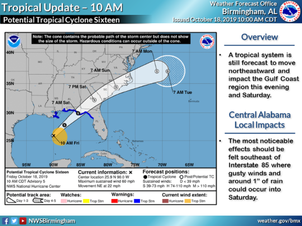
As PTC-16 continues on its northeasterly path through the eastern half of the southeast, Central Alabama will see some rainfall and some breezy conditions. The main impact window will start around midnight tonight and go through the evening hours on Saturday.
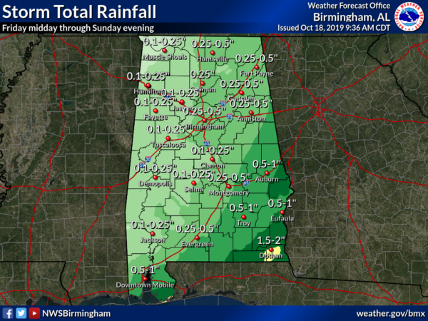
Much of Central Alabama will see less than 1/2 inch of rain with heavier totals of 1 to 1-1/2 inches possible in the southeastern parts of the area (along and south of the I-85 corridor east of I-65). Some of the extreme western and northwestern parts of the area could go the entire day and may not even see a drop of rain. There will be no issues with flash flooding with PTC-16.
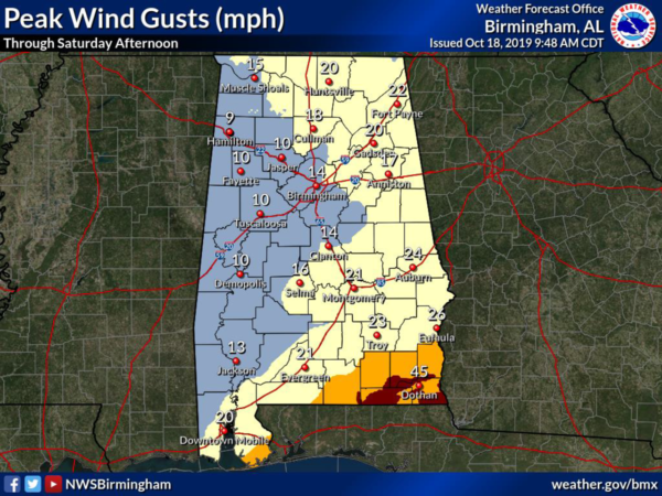
Much of Central Alabama will only see peak wind gusts up to 10-20 MPH while 20-30 MPH wind gusts are possible for the southeastern parts of the area (along and south of the I-85 corridor east of I-65). Higher gusts of 40-50 MPH will take place near the center as it passes through, mainly over portions of Covington, Coffee, Dale, Geneva, Henry, and Houston counties in South Alabama.
Rain will come to an end during the afternoon hours from southwest to northeast across the area and we could see some sunshine at times peeking through the overcast. With the rain and clouds, highs will be limited to the mid-60s to the lower 70s.
If going to the football games on Saturday, you may encounter a brief shower or two at Legion Field for the UAB game, but rain should be out of the area for the Alabama game on Saturday night.
POTENTIAL SEVERE WEATHER THREAT ON MONDAY

A strong cold front will be approaching Central Alabama and eventually moving through the area on Monday. There is a potential for strong to severe storms across the western and northwestern parts of the area mainly during the afternoon hours on Monday. Wind profiles may be supportive of storms capable of producing isolated damaging winds and a brief tornado or two. We’ll keep you posted.
Category: Alabama's Weather, ALL POSTS, Tropical
About the Author (Author Profile)
Scott Martin is an operational meteorologist, professional graphic artist, musician, husband, and father. Not only is Scott a member of the National Weather Association, but he is also the Central Alabama Chapter of the NWA president. Scott is also the co-founder of Racecast Weather, which provides forecasts for many racing series across the USA. He also supplies forecasts for the BassMaster Elite Series events including the BassMaster Classic.Subscribe
If you enjoyed this article, subscribe to receive more just like it.


