

NWS Birmingham Update: Central Alabama Impacts From PTC-16
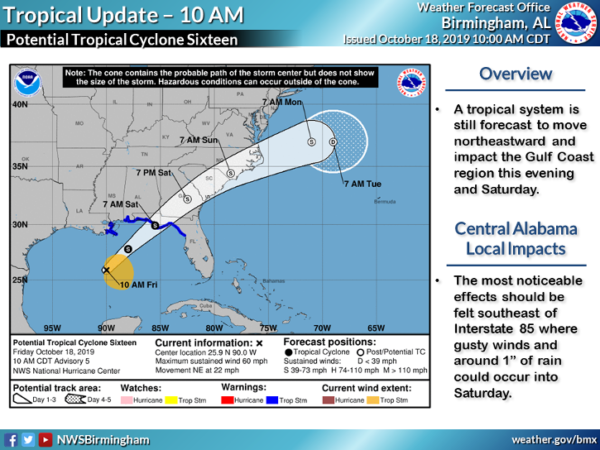
NWS Birmingham just completed a conference call with the local meteorologists and emergency management agencies to give us an update on what they expect the impacts on Central Alabama will be from PTC-16. Really, there is not much change from what was reported from Thursday, which is good news and bad news.
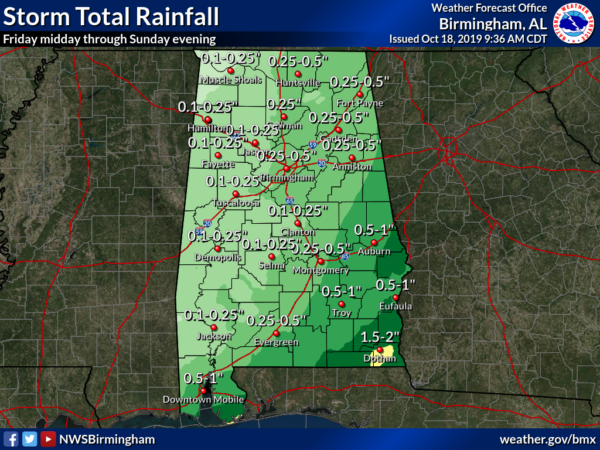
Unfortunately, some locations along and north of the I-59/20 corridor west of the I-65 corridor will see very little, if any, rainfall at all from PTC-16. Totals in those locations will be 1/4 inch or less. Much of the same story for locations west of I-65 south of the I-59/20 corridor… Rainfall will be a little more likely but totals will still be rather small at 1/4 inch or less.
For locations east of the I-65 corridor, you will be a little more fortunate with rainfall from PTC-16. North of I-20, totals look to be in the 1/4 to 1/2 inch range, while south of that we could see 1/2 inch to 1 inch totals. There may be some localized higher amounts approaching or exceeding 1-1/2 inches in the extreme southeastern parts of Central Alabama, but the much higher amounts will be confined mostly to locations that will be on the east side of the center of rotation.
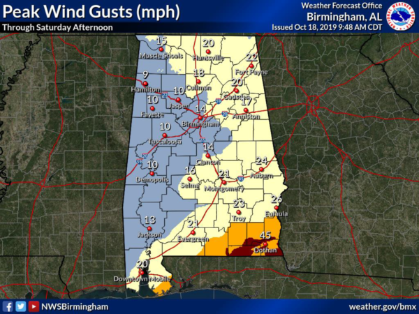
The good news is that the higher wind gusts associated with PTC-16 will be confined closer to the center of circulation as it moves northeast. For most locations in Central Alabama, peak wind gusts are only expected to be around 10-20 MPH. Higher gusts up to 20-30 MPH are expected for locations along and east of I-65 in the southeastern parts of the area (along and south of I-85). Wind gusts up to 40-50 MPH may be seen in the southeastern corner of the state over portions of Covington, Coffee, Dale, Geneva, Henry, and Houston counties.
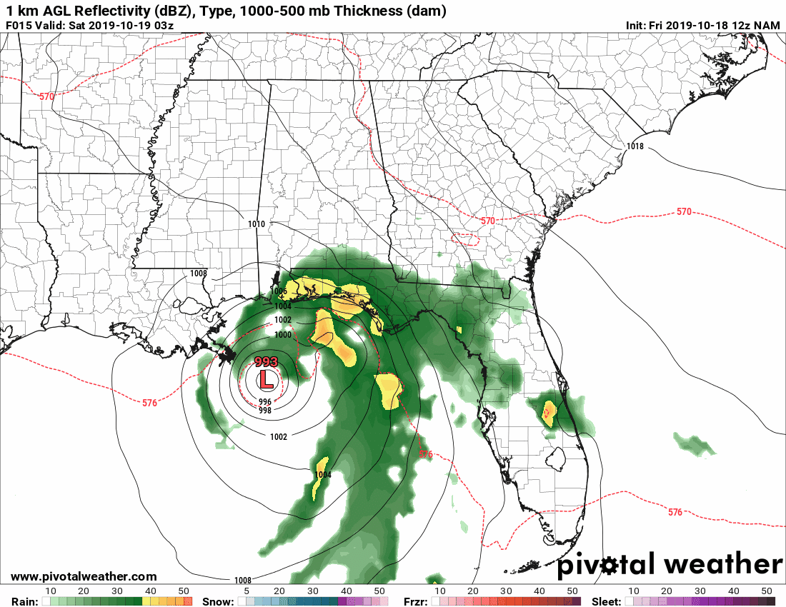
The main window of impacts across Central Alabama from PTC-16 looks to start just after midnight tonight and will continue through much of the day with nearly all of the rainfall out of the area by 7:00 pm Saturday evening. As you can see, the center is forecast on this model run to pass over Dothan just after the noon hour on Saturday.
Where there is a non-zero threat of a quick spin-up tropical-type tornado over the southeastern portions of Central Alabama, those will be highly unlikely to occur in Alabama. That threat will occur over the eastern panhandle of Florida and up into the southern half of Georgia.
We’ll continue to have updates throughout the day today and tomorrow on PTC-16. We’ll have one day to slow down on Sunday before we’re right back at it with the potential of strong to marginally severe storms for parts of the area on Monday with an approaching strong cold front.
Category: Alabama's Weather, ALL POSTS, Severe Weather, Tropical
About the Author (Author Profile)
Scott Martin is an operational meteorologist, professional graphic artist, musician, husband, and father. Not only is Scott a member of the National Weather Association, but he is also the Central Alabama Chapter of the NWA president. Scott is also the co-founder of Racecast Weather, which provides forecasts for many racing series across the USA. He also supplies forecasts for the BassMaster Elite Series events including the BassMaster Classic.Subscribe
If you enjoyed this article, subscribe to receive more just like it.


