

10:00 am Update: Not Yet a Tropical Storm, but PTC-16 is Stronger

SUMMARY OF 1000 AM CDT…1500 UTC…INFORMATION
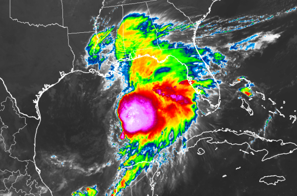
LOCATION…25.9N 90.0W
ABOUT 230 MI…365 KM SSW OF THE MOUTH OF THE MISSISSIPPI RIVER
ABOUT 395 MI…635 KM SW OF PANAMA CITY FLORIDA
MAXIMUM SUSTAINED WINDS…60 MPH…95 KM/H
PRESENT MOVEMENT…NE OR 55 DEGREES AT 22 MPH…35 KM/H
MINIMUM CENTRAL PRESSURE…1001 MB…29.56 INCHES
SUMMARY OF WATCHES AND WARNINGS IN EFFECT
A Tropical Storm Warning is in effect for…
* Mississippi/Alabama border to Yankeetown Florida
* Grand Isle Louisiana to the Mouth of the Pearl River
A Storm Surge Warning is in effect for…
* Indian Pass Florida to Clearwater Beach Florida
DISCUSSION AND OUTLOOK
At 1000 AM CDT (1500 UTC), the disturbance was centered near latitude 25.9 North, longitude 90.0 West. The system is moving toward the northeast near 22 mph (35 km/h), and this general motion is expected to continue through Sunday, followed by a turn toward the east-northeast by early Monday. On the forecast track, the system will approach the northern Gulf Coast later today and tonight and move inland across portions of the southeastern United States on Saturday and Sunday. The system is forecast to move offshore of the coast of North Carolina by late Sunday.
Data from a NOAA Hurricane Hunter aircraft indicate that maximum sustained winds have increased to near 60 mph (95 km/h) with higher gusts. Some additional strengthening is expected later today, with weakening forecast after the system moves inland.
The disturbance is expected to become a tropical or subtropical storm later today.
* Formation chance through 48 hours…high…90 percent
* Formation chance through 5 days…high…90 percent
Tropical-storm-force winds extend outward up to 175 miles (280 km), mainly to the northeast and east of the center. The estimated minimum central pressure based on data from the NOAA Hurricane Hunter aircraft is 1001 mb (29.56 inches).
HAZARDS AFFECTING LAND
STORM SURGE: The combination of a dangerous storm surge and the tide will cause normally dry areas near the coast to be flooded by rising waters moving inland from the shoreline. The water could reach the following heights above ground somewhere in the indicated areas if the peak surge occurs at the time of high tide…
Indian Pass FL to Chassahowitzka FL…3 to 5 ft
Chassahowitzka to Clearwater Beach FL…2 to 4 ft
Tampa Bay…1 to 3 ft
Surge-related flooding depends on the relative timing of the surge and the tidal cycle, and can vary greatly over short distances.
WIND: Tropical storm conditions are expected to reach the coast within the warning area by later today and this evening, making outside preparations difficult or dangerous. Gale-force winds are likely along portions of the Atlantic coast of the southeastern United States by Saturday.
RAINFALL: The disturbance is expected to produce total rainfall accumulations of 2 to 4 inches this weekend from the central Gulf Coast and northern and central Florida to the eastern Carolinas, with isolated maximum amounts of 6 inches.
TORNADOES: A tornado or two is possible tonight and early Saturday near the Florida Gulf Coast from the central panhandle to the western peninsula.
About the Author (Author Profile)
Scott Martin is an operational meteorologist, professional graphic artist, musician, husband, and father. Not only is Scott a member of the National Weather Association, but he is also the Central Alabama Chapter of the NWA president. Scott is also the co-founder of Racecast Weather, which provides forecasts for many racing series across the USA. He also supplies forecasts for the BassMaster Elite Series events including the BassMaster Classic.Subscribe
If you enjoyed this article, subscribe to receive more just like it.


