A Late Afternoon Look at a Disorganized Tropical Storm Nestor
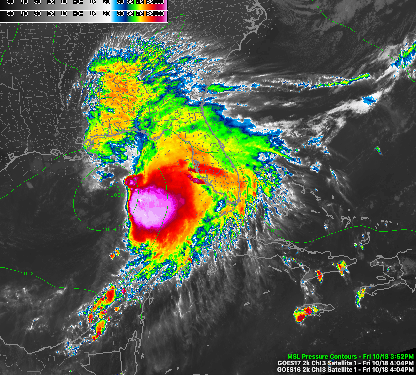
Tropical Storm Nestor isn’t going to win any tropical cyclone beauty contests, for sure.
The disorganized storm is moving quickly toward the northeast at 22 mph.
On its forecast track, the center will cross the coast near Cape San Blas, to the southeast of Panama City and just west of Apalachicola around 5 a.m. Saturday morning.
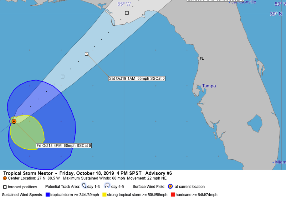
The wind field is very asymmetrical, as shown by this tracking map. The Air Force Reserve WC-130 plane found a lot of 35-45 mph winds well to the east and southeast of the center. Winds in the left semicircle are considerably lower.
Bands of heavy rain will move onshore this evening from east of Destin to the Florida Big Bend area and a band of strong storms will move onshore along the Florida West coast south of the Big Bend during the early morning hours after midnight.
Winds will reach tropical storm force along the coast in areas from the Beaches of 30A to St. Joe between 10 p.m. and 1 a.m.
Winds over 50 mph may be felt from Panama City over to St. Marks and up to Tallahassee between 3 a.m. and 9 a.m. The tropical-storm-force winds (greater than 39 mph) will be felt as far northeast as Savannah, Columbia, Charlotte, Raleigh, and the Outer Banks of North Carolina.
Rainfall will run 4-5 inches from the landfall point to near Tallahassee. 2-4 inch amounts will fall across the eastern Florida Panhandle from Panama City eastward into Georgia. 1-3 inch amounts to will measured as far northeast as eastern North Carolina.
Higher than average tides will run 1-2 feet along the Alabama and Northwest Florida Coast to the west of the center’s landfall. Tides of 2-5 feet will impact the Florida Big Bend and West Coast of Florida as far south as Clearwater Beach. Tides of 1-3 feet above normal will impact the Tampa Bay area.
Tornadoes may be a threat in the Big Bend area and along the western coast of Florida late tonight and early Saturday.
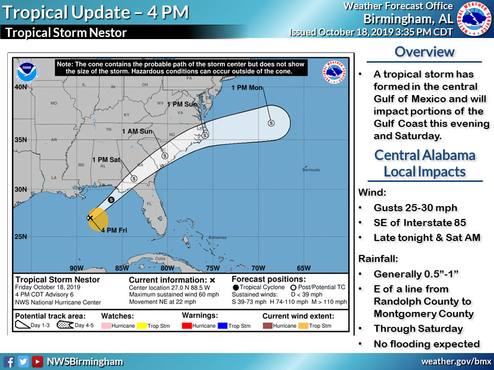
Across Central Alabama, winds will become gusty after midnight tonight southeast of I-85, and will gust to 25-30 mph through Saturday morning.
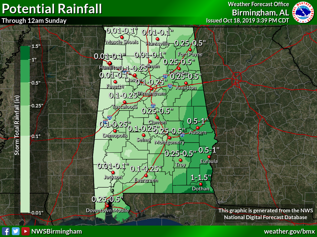
Rainfall may approach 1 inch in areas south east of a line from Montgomery to Wedowee. Northwest of that, rainfall will be spotty.
Category: Alabama's Weather, ALL POSTS, Tropical
About the Author (Author Profile)
Bill Murray is the President of The Weather Factory. He is the site's official weather historian and a weekend forecaster. He also anchors the site's severe weather coverage. Bill Murray is the proud holder of National Weather Association Digital Seal #0001 @wxhistorianSubscribe
If you enjoyed this article, subscribe to receive more just like it.


