Conditions Along Gulf Coast Will Start Deteriorating As Nestor Continues To Move Closer To Shore
NESTOR MOVING QUICKLY TOWARD THE NORTHERN GULF COAST. STORM SURGE AND WINDS WILL INCREASE IN THE NEXT FEW HOURS.
SUMMARY OF 400 PM CDT…2100 UTC…INFORMATION
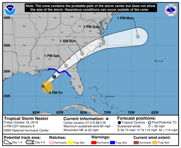
LOCATION…27.0N 88.5W
ABOUT 150 MI…240 KM SSE OF THE MOUTH OF THE MISSISSIPPI RIVER
ABOUT 280 MI…450 KM SW OF PANAMA CITY FLORIDA
MAXIMUM SUSTAINED WINDS…60 MPH…95 KM/H
PRESENT MOVEMENT…NE OR 50 DEGREES AT 22 MPH…35 KM/H
MINIMUM CENTRAL PRESSURE…999 MB…29.50 INCHES
WATCHES AND WARNINGS
CHANGES WITH THIS ADVISORY: The Tropical Storm Warning has been discontinued from Grand Isle, Louisiana to the Mouth of the Pearl River, and from the Mississippi/Alabama border to west of Navarre, Florida.
A Tropical Storm Warning is in effect for…
* Navarre Florida to Yankeetown Florida
A Storm Surge Warning is in effect for…
* Indian Pass Florida to Clearwater Beach Florida
DISCUSSION
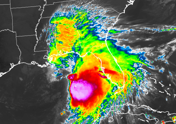
Nestor’s structure has evolved quite a bit today. Since the release of the previous advisory, the center has become better defined based on data from aircraft, satellite, and surface observations, and on that basis, the system was classified as a tropical cyclone around 1800 UTC. Since that time, the center has become more separated from the area of deep convection to the east, consistent with 30-40 kt of deep-layer westerly shear analyzed by the SHIPS model and UW-CIMSS. The initial intensity remains 50 kt based on aircraft data and earlier ASCAT data.
The mid/upper-level trough seen in water vapor imagery over southeastern Louisiana is beginning to impinge on Nestor, and the cloud pattern has become more lopsided. It would not be surprising to see Nestor take on a more subtropical appearance overnight, as the GFS and ECMWF show the upper trough becoming superimposed on the low-level circulation, with the pressure continuing to deepen and some increase in the peak winds noted in both those models. This is reflected in the 12-h intensity forecast of 55 kt. After that time, the upper-level pattern becomes less favorable and Nestor should weaken while it moves inland over the southeastern United States and becomes post-tropical. Gale-force winds are shown over the western Atlantic waters, but are not expected over land areas from 24 h onward. The global models show Nestor’s circulation dissipating by 96 hours, and that is reflected in the NHC forecast.
The initial motion estimate is 050/19, but remains somewhat uncertain given the recent formation of a better defined center. The track forecast reasoning remains unchanged, with Nestor expected to move quickly northeastward ahead of the approaching upper trough and moving inland over the Florida Panhandle early Saturday. The circulation center will move across the southeastern United States before moving back offshore after 48 hours with a slower east-northeastward to eastward motion shown late in the period before dissipation. The new NHC track forecast lies a little to the right of the previous and is close to the middle of the guidance envelope. It should be noted that dangerous storm surge and tropical storm force winds will occur along a large portion of the Gulf Coast well east of the track of Nestor’s center.
KEY MESSAGES
1. There is a danger of life-threatening storm surge inundation of up to 5 feet above ground level beginning this evening along the Florida Gulf Coast from Indian Pass to Clearwater Beach, where a Storm Surge Warning is in effect. Residents in these areas should follow advice given by local officials.
2. Tropical storm force winds are likely later today and tonight along portions of the Florida Gulf Coast, where tropical storm warnings are in effect. Regardless of the exact track and intensity of the system, these winds will cover a large area, especially east of the center.
3. Isolated flash flooding is possible along the central and eastern Gulf Coast and Southeast United States coast from late tonight through Sunday.
4. Wind and coastal flooding hazards along the U.S. East Coast will be covered by non-tropical watches and warnings issued by local NWS offices, since the system is expected to lose its tropical characteristics after it moves inland along the Gulf Coast.
About the Author (Author Profile)
Scott Martin is an operational meteorologist, professional graphic artist, musician, husband, and father. Not only is Scott a member of the National Weather Association, but he is also the Central Alabama Chapter of the NWA president. Scott is also the co-founder of Racecast Weather, which provides forecasts for many racing series across the USA. He also supplies forecasts for the BassMaster Elite Series events including the BassMaster Classic.Subscribe
If you enjoyed this article, subscribe to receive more just like it.


