

7:00 AM Update On Tropical Storm Nestor
STRONG GUSTY WINDS AND STORM SURGE AFFECTING THE COAST OF THE FLORIDA PANHANDLE.
NESTOR STEADILY LOSING ITS TROPICAL CHARACTERISTICS.
SUMMARY OF 700 AM CDT…1200 UTC…INFORMATION
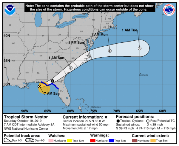
LOCATION…29.5N 86.8W
ABOUT 80 MI…125 KM WSW OF PANAMA CITY FLORIDA
ABOUT 110 MI…175 KM W OF APALACHICOLA FLORIDA
MAXIMUM SUSTAINED WINDS…50 MPH…85 KM/H
PRESENT MOVEMENT…NE OR 45 DEGREES AT 17 MPH…28 KM/H
MINIMUM CENTRAL PRESSURE…996 MB…29.41 INCHES
WATCHES AND WARNINGS
A Tropical Storm Warning is in effect for…
* Okaloosa/Walton County line to Yankeetown Florida
A Storm Surge Warning is in effect for…
* Indian Pass Florida to Clearwater Beach Florida
DISCUSSION AND OUTLOOK
At 700 AM CDT (1200 UTC), satellite imagery, NOAA Doppler weather radar data, and surface observations indicate that the center of Tropical Storm Nestor has redeveloped farther west near latitude 29.5 North, longitude 86.8 West. Nestor is moving toward the northeast near 17 mph (28 km/h). Some erratic motion toward the northeast or east-northeast is expected through this morning. A turn toward the east-northeast is forecast to occur Sunday. On the forecast track, Nestor will move inland over the Florida Panhandle late this morning or early afternoon, and will then move across portions of the southeastern United States later today and Sunday as a post-tropical cyclone. Nestor is expected to move offshore of the coast of North Carolina into the western Atlantic by late Sunday also as a post-tropical cyclone.
Doppler radar data and surface observations indicate that maximum sustained winds remain near 50 mph (85 km/h) with higher gusts. No change in strength is anticipated before Nestor reaches the coast, but weakening is forecast to begin after the cyclone moves inland. Nestor is expected to lose tropical characteristics and become post-tropical by early afternoon.
Tropical-storm-force winds extend outward up to 160 miles (260 km) mainly to the east of the center. The Tyndall AFB Tower located south of Apalachicola, Florida, recently reported a sustained wind of 49 mph (80 km/h) and a gust to 61 mph (98 km/h) at an elevation of 115 ft (35 m).
A National Ocean Service tide gauge at Apalachicola, Florida, recently measured a water level of 3.2 ft above Mean Higher High Water. The minimum central pressure based on nearby surface observations is estimated to be 996 mb (29.41 inches).
HAZARDS AFFECTING LAND
STORM SURGE: The combination of a dangerous storm surge and the tide will cause normally dry areas near the coast to be flooded by rising waters moving inland from the shoreline. The water could reach the following heights above ground somewhere in the indicated areas if the peak surge occurs at the time of high tide…
Indian Pass FL to Chassahowitzka FL…3 to 5 ft
Chassahowitzka to Clearwater Beach FL…2 to 4 ft
Tampa Bay…1 to 3 ft
Surge-related flooding depends on the relative timing of the surge and the tidal cycle, and can vary greatly over short distances.
WIND: Tropical storm conditions are expected to reach or are already reaching the coast within the warning area, and will continue through this afternoon. Gale-force winds are likely to begin along portions of the Atlantic coast of the southeastern United States later today.
RAINFALL: Nestor is expected to produce total rainfall accumulations of 2 to 4 inches this weekend across portions of the southeastern United States, with isolated maximum amounts of 8 inches.
TORNADOES: A few tornadoes are possible through midday in the northern and central Florida Peninsula, and later today and tonight over coastal areas of Georgia and the Carolinas.
About the Author (Author Profile)
Scott Martin is an operational meteorologist, professional graphic artist, musician, husband, and father. Not only is Scott a member of the National Weather Association, but he is also the Central Alabama Chapter of the NWA president. Scott is also the co-founder of Racecast Weather, which provides forecasts for many racing series across the USA. He also supplies forecasts for the BassMaster Elite Series events including the BassMaster Classic.Subscribe
If you enjoyed this article, subscribe to receive more just like it.


