

Post-Tropical Cyclone Nestor Is Inland Over The Florida Panhandle
POST-TROPICAL CYCLONE NESTOR INLAND OVER THE FLORIDA PANHANDLE.
THIS IS THE LAST ADVISORY FROM THE NATIONAL HURRICANE CENTER.
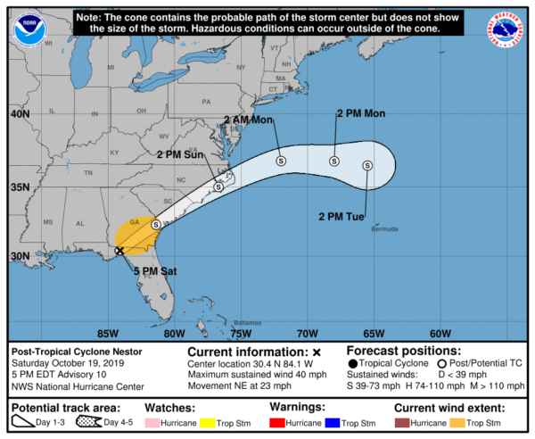
SUMMARY OF 500 PM EDT…2100 UTC…INFORMATION
LOCATION…30.4N 84.1W
ABOUT 70 MI…115 KM NE OF APALACHICOLA FLORIDA
ABOUT 10 MI…20 KM E OF TALLAHASSEE FLORIDA
MAXIMUM SUSTAINED WINDS…40 MPH…65 KM/H
PRESENT MOVEMENT…NE OR 55 DEGREES AT 23 MPH…37 KM/H
MINIMUM CENTRAL PRESSURE…999 MB…29.50 INCHES
WATCHES AND WARNINGS
CHANGES WITH THIS ADVISORY: The Tropical Storm Warning has been discontinued for the Gulf coast of Florida. There are no tropical cyclone coastal watches or warnings in effect.
DISCUSSION
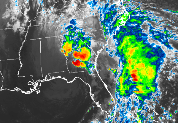
The center of Post-Tropical Cyclone Nestor made landfall along on St. Vincent Island, Florida, around 1730 UTC. Since then, that center has moved inland over the Florida Panhandle between Apalachicola and Tallahassee. However, during the past hour, a new center appears to have formed farther west along a quasi-occluded frontal boundary. The earlier 40-45 kt winds over water have moved inland and weakened, and the initial intensity of 35 kt is based on a recent wind report of a sustained wind of 33 kt at 5-meters elevation from NOAA buoy 41008/Gray’s Reef, Georgia.
The initial motion estimate is now northeastward or 055/20 kt. Nestor is forecast to move northeastward over the next 36 hours or so, followed by a turn toward the east once the cyclone reaches the North Carolina Outer Banks. On days 2 an 3, upper-level support is expected to weaken and lift out to the northeast, leaving a weakening extratropical cyclone Nestor behind. The cyclone should then dissipate or merge with another frontal system by 96 h offshore of the U.S. east coast. The new official forecast track is similar to the previous advisory, and lies close to the center of the tightly packed model guidance envelope.
Some slight strengthening is expected on Sunday, mainly due to the robust circulation moving out over the warm waters of the far western Atlantic where less friction will affect the cyclone. The official intensity foreast closely follows an average of the 1200 UTC GFS, UKMET, and ECMWF global model intensity forecasts.
This is the last advisory issued by the National Hurricane Center on Nestor.
KEY MESSAGES
1. Gale-force winds will gradually develop over the Atlantic waters and along the coasts northeastern Florida and Georgia tonight, and spread northward to the Carolinas on Sunday.
2. Isolated flash flooding is possible across the southeastern United States into Sunday.
About the Author (Author Profile)
Scott Martin is an operational meteorologist, professional graphic artist, musician, husband, and father. Not only is Scott a member of the National Weather Association, but he is also the Central Alabama Chapter of the NWA president. Scott is also the co-founder of Racecast Weather, which provides forecasts for many racing series across the USA. He also supplies forecasts for the BassMaster Elite Series events including the BassMaster Classic.Subscribe
If you enjoyed this article, subscribe to receive more just like it.


