Weather Xtreme Video for Sunday, October 20, 2019: Warm Today, Severe Weather Possible Monday
Post-Tropical Cyclone Nestor is moving through eastern North Carolina this morning after delivering a day of raw, cool, drizzly, rainy weather day of weather to Central Alabama. Today will be quite a different day across the state as summer tries a last hurrah.
SATURDAY HIGHS: Highs across Central Alabama on Saturday ranged from 56F at Shoal Creek in St. Clair County, to 57F at Gadsden, to 58F at Anniston, too 59F at Pell City, to 61F at Birmingham, to 62F at Calera, to 70F at Tuscaloosa, to 72F at Demopolis. Montgomery checked in at 66F. Some sunshine snuck in at the end of the day in southwestern sections of the area giving those highs near 70F. Montgomery picked up 1.53 inches of rain and Anniston 1.01 inches. Birmingham only grabbed 0.09 inches in a nearly day-long drizzle-fest.
WHAT A DIFFERENCE A DAY MAKES: A broad west-southwesterly flow aloft and building high pressure over Alabama and the Deep South means improving weather conditions for your Sunday. We are starting off with a little dense fog and low cloudiness across the area I the higher moisture leftover from yesterday. Clearing skies overnight allowed for excellent radiational cooling conditions that were perfect for fog formation. Watch out for reduced visibility in some areas. But the fog and low clouds will burn off fairly quickly and highs today will warm into the upper 70s over North Alabama and rise to around 80-82F over the central part of the state. Dewpoints will remain fairly low early today but will start to rise this afternoon as southerly winds increase ahead of our next storm system. Lows tonight will only fall into the lower and middle 60s.
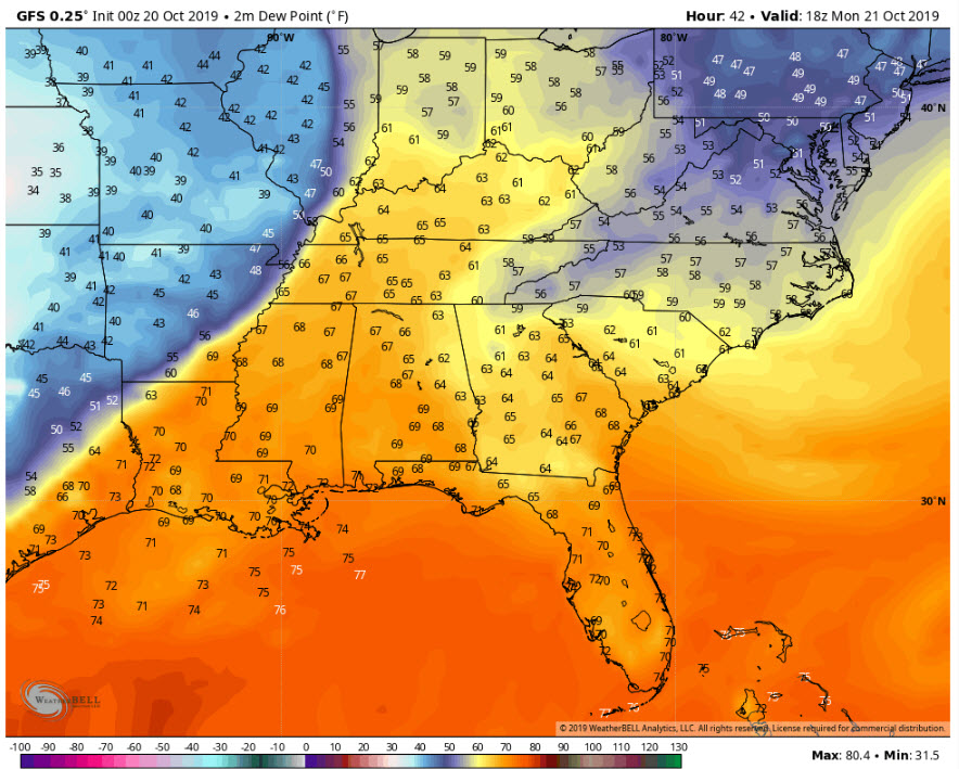
Dewpoints at Noon Monday from the GFS
MONDAY SEVERE WEATHER: By late tonight, low pressure will be moving through the Midwest, and by Monday morning, it will have consolidated its power over Iowa, with a strong, trailing cold front back into eastern Texas. Ahead of the system, moisture levels will be on the rise and by noon Monday, dewpoints will be in the middle and upper 60s in all areas west of I-65. High temperatures will rise to near 80F, much like today. This despite some morning and early afternoon cloudiness and showers that may develop. A strong low-level jet will overspread western sections of Alabama by mid-afternoon, creating a good bit of shear. But instability values appear that they will be fairly low, less than 750 joules/kg in CAPE.
This sets the stage for a low instability, high shear situation that we are all too used to in the fall in Alabama. A line of strong storms will advance through Mississippi during the afternoon. This line will move into western Alabama during the late afternoon and evening hours. Some of the storms could be severe as they advance across North and Central Alabama. Damaging winds will be possible, as we as a brief tornado or two. The main threat will be between 3 p.m. and 3 a.m. This is a low confidence forecast at this time.
BENEFICIAL RAINS: High precipitable water values will spread into Alabama on Monday, setting the stage for some decent rainfall amounts. 1-1.5 inches of rainfall will be likely across the northern half of the state. Certainly not a drought buster, but we will take it.
DROUGHTWATCH: The drought is actually worsening across Alabama, despite the recent breaking of the heatwave. Our Drought Severity and Coverage Index jumped from 168 to 192 over the last two weeks. Much of the area from Bibb, Chilton, Shelby, and southern Jefferson Counties up into the northeastern part of the state is in desperate need of rainfall. Monday’s rain may help on top of what fell over eastern Alabama on Saturday.
GULF COAST WEATHER: Sunny skies today along the beautiful beaches of Alabama and Northwest Florida. Highs today will be near 80F. Rain will return Monday night, but it should be over by Tuesday evening. High pressure will build in for Wednesday and Thursday, but moisture will begin returning late Thursday with the prospects for a wet weekend looking. Highs will be in the 70s all week with lows in the 50s and 60s. Water temperatures are running around 77F. Seas and a higher rip current risk will begin abating later today. Click here to see the Beach Forecast Center page.
TROPICS: It seems that Nestor was more Potential and Post than Tropical Storm, but the persistent little system is finally moving on out this morning. The rest of the tropics is quiet for now. We probably will see one or two more named storms before the season is over. My money is on a named storm near the Azores around November 1.
WEATHERBRAINS: This week, the panel will entertain the CEO of a lightning warning system called Thor Guard and our old friend Kevin Kloesel from the University of Oklahoma. Check out the show at www.WeatherBrains.com. You can also subscribe on iTunes. You can watch the show live at live.bigbrainsmedia.com You will be able to see the show on the James Spann 24×7 weather channel on cable or directly over the air on the dot 2 feed.
ON THIS DATE IN 1998: ”Mr. Tornado,” Famed tornado researcher Theodore Fujita passed away after a long illness on this date. Fujita was 78. He developed the famous Fujita scale which is used to classify the damage caused by tornadoes. Fujita also discovered microbursts – sudden, severe downdrafts that can result in 150 mph winds on or near the ground – after studying the starburst patterns of trees uprooted by tornadoes. He blamed microbursts for the 1975 Eastern Airlines Flight 66 crash at New York’s Kennedy Airport. The discovery, controversial for years before it became accepted among meteorologists, led to installation of Doppler radar at airports to improve safety. Follow my weather history tweets on Twitter. I am @wxhistorian at Twitter.com.
Category: Alabama's Weather, ALL POSTS
About the Author (Author Profile)
Bill Murray is the President of The Weather Factory. He is the site's official weather historian and a weekend forecaster. He also anchors the site's severe weather coverage. Bill Murray is the proud holder of National Weather Association Digital Seal #0001 @wxhistorianSubscribe
If you enjoyed this article, subscribe to receive more just like it.


