

Watch Possible For Extreme Southern Alabama & The Florida Panhandle
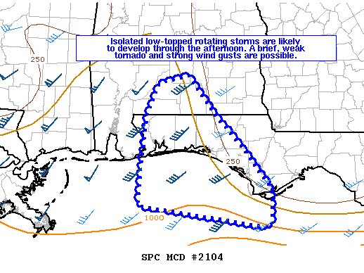
Mesoscale Discussion 2104
NWS Storm Prediction Center Norman OK
0149 PM CDT Mon Oct 21 2019
Areas affected…western Florida Panhandle into south-central Alabama
Concerning…Severe potential…Watch possible
Probability of Watch Issuance…40 percent
SUMMARY…Isolated low-topped rotating showers are likely to continue developing in the northern Gulf of Mexico and across southern Alabama and the western Florida Panhandle through the afternoon.
DISCUSSION…A few low-topped showers have developed across southern Alabama and offshore from the western Florida Panhandle in the last 1-2 hours. While no CG lightning has been observed (via Vaisala NLDN), these storms are weakly rotating via KEVX. Modest buoyancy is limiting the depth of these storms to around 10-13,000 feet with a subsidence layer residing around 800-675 mb per observations and mesoanalysis. High-level cirrus from the MCS to the west is limiting surface heating over the northern Gulf and central Gulf Coast, but enough instability is present to foster isolated convection. Deep layer shear (40-50 knots effective bulk shear) and low-level veering with height winds being enhanced by a wind shift/pseudo-warm front south of the Florida Panhandle, will likely result in rotating storms. A brief, weak tornado and strong wind gusts are possible with these discrete storms through the afternoon.
Category: Alabama's Weather, ALL POSTS, Severe Weather
About the Author (Author Profile)
Scott Martin is an operational meteorologist, professional graphic artist, musician, husband, and father. Not only is Scott a member of the National Weather Association, but he is also the Central Alabama Chapter of the NWA president. Scott is also the co-founder of Racecast Weather, which provides forecasts for many racing series across the USA. He also supplies forecasts for the BassMaster Elite Series events including the BassMaster Classic.Subscribe
If you enjoyed this article, subscribe to receive more just like it.


