

One More Dry Day Before Rain Returns
**No afternoon Weather Xtreme video today**
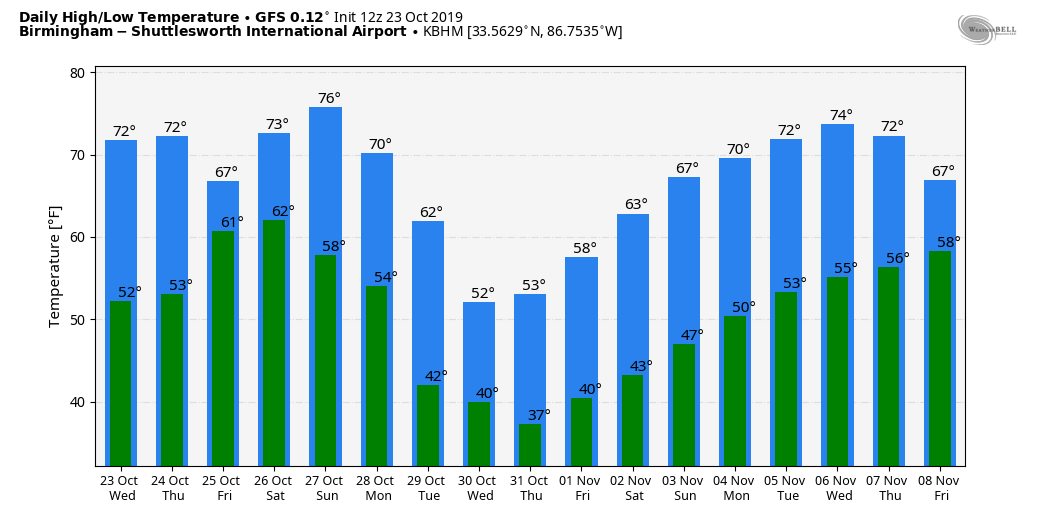
CLOUDLESS SKY: Quite the fall day for Alabama. A cobalt blue sky, low humidity, and temperatures mostly in the upper 60s and low 70s. Tonight will be clear and cold again; most places will drop into the 40-45 degree range, but again the colder spots could see 30s. We note the coldest spot in Alabama this morning was Black Creek, just northeast of Gadsden, with 33 degrees. There was scattered frost across the northern half of Alabama.
The weather will stay dry tomorrow; with ample sunshine we project a high in the mid 70s. Clouds move in tomorrow night.
FRIDAY AND THE WEEKEND: A warm front will move slowly through the state Friday, and that should set the stage for a widespread, soaking rain event. Rain begins Friday morning, and will continue through the afternoon and nighttime hours… temperatures hold in the 60s through the day with clouds and rain.
Then, on Saturday, the weather stays wet with an upper trough to the west, and a very moist airmass in place. We are forecasting occasional showers and thunderstorms Saturday into Saturday night… a few strong storms are possible during the afternoon and evening hours as the air becomes marginally unstable. It won’t rain all day Saturday, but the rain could come at any time.
Heaviest rain Friday and Saturday will fall over the northern and western part of Alabama; rain totals of 2-4 inches are likely there, and some flooding issues are very possible before it all ends late Saturday night.
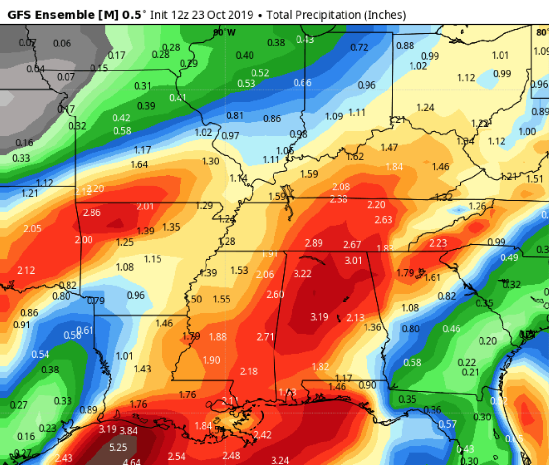
Sunday looks dry; the sky becomes partly sunny during the day as the main shifts east of the state. Highs over the weekend will be in the low to mid 70s.
NEXT WEEK: The week looks mostly dry, and the coolest air so far this season should invade the Deep South by Thursday. Some parts of Alabama could see the first freeze of the season late next week.
TROPICS: A disturbance will move into the far Southwest Gulf of Mexico tomorrow; NHC gives it a 30 percent chance of development over the next five days. The rest of the Atlantic basin is quiet.
FOOTBALL WEATHER: For the high school games Friday night, the sky will be cloudy with widespread rain likely; temperatures will be in the low 60s.
For Saturday’s Magic City Classic at Legion Field in Birmingham (Alabama State vs Alabama A&M, 2:30p CT kickoff), the sky will be cloudy, and periods of rain are likely. A thunderstorm can’t be ruled out. Kickoff temperature near 70 degrees, falling into the upper 60s by the final whistle.
Auburn travels to Baton Rouge Saturday to take on LSU (2:30p CT kickoff)… the sky will be mostly cloudy, and a few passing showers are possible during the game. Temperatures will fall from the upper 60s at kickoff into the mid 60s by the fourth quarter.
It is homecoming at the University of Alabama Saturday; the Tide will host Arkansas at Bryant-Denny Stadium (6:00p CT kickoff). It looks like rain will fall at times during the game, with a thunderstorm possible as well. Temperatures will fall from near 70 at kickoff, into the upper 60s by the second half.
Jacksonville State will host Murray State Saturday (3:00p CT kickoff)… cloudy conditions are expected with some rain at times; temperatures will be in the upper 60s during the game.
ON THIS DATE IN 2015: Hurricane Patricia became the most powerful tropical cyclone ever measured in the Western Hemisphere as its maximum sustained winds reached an unprecedented 200 mph (320 kph) and its central pressure fell to 879 millibars (25.96 inches of mercury). Hurricane Patricia became the strongest Pacific hurricane on record shortly after midnight CDT early on Oct. 23. Air Force Hurricane Hunters had flown through the eye of Patricia and reported a sea-level pressure of 894 millibars as measured by a dropsonde inside the eye itself. Wind measurements suggested that the pressure measurement was not in the exact center of the eye and was probably not the absolute lowest pressure, prompting NHC to estimate the minimum central pressure at 892 millibars in its special 12:30 a.m. CDT advisory. Tropical cyclone strength comparisons are typically based on minimum central pressure. At 892 millibars, Patricia shattered the Eastern Pacific basin’s previous record of 902 millibars set by Hurricane Linda in 1997. While a number of typhoons in the western North Pacific have been stronger, Patricia is now by far the strongest hurricane on record in any basin where the term “hurricane” applies to tropical cyclones – namely, the central and eastern North Pacific basins and the North Atlantic basin, which includes the North Atlantic Ocean itself plus the Gulf of Mexico and Caribbean Sea.
BEACH FORECAST: Click here to see the AlabamaWx Beach Forecast Center page.
WEATHER BRAINS: Don’t forget you can listen to our weekly 90 minute show anytime on your favorite podcast app. This is the show all about weather featuring many familiar voices, including our meteorologists here at ABC 33/40.
CONNECT: You can find me on all of the major social networks…
Facebook
Twitter
Instagram
Pinterest
Snapchat: spannwx
I enjoyed seeing students today at East Elementary in Cullman, and Erwin Intermediate in Center Point… be looking for them on the Pepsi KIDCAM today at 5:00 and 6:00 on ABC 33/40 News! The next Weather Xtreme video will be posted here by 7:00 a.m. tomorrow…
Category: Alabama's Weather, ALL POSTS
About the Author (Author Profile)
James Spann is one of the most recognized and trusted television meteorologists in the industry. He holds the AMS CCM designation and television seals from the AMS and NWA. He is a past winner of the Broadcast Meteorologist of the Year from both professional organizations.Subscribe
If you enjoyed this article, subscribe to receive more just like it.


