Tropical Depression 17 Forms Over The Western Gulf Of Mexico, Further Strengthening Possible
TROPICAL DEPRESSION FORMS IN THE WESTERN GULF OF MEXICO.
EXPECTED TO BECOME A GALE-FORCE POST-TROPICAL LOW TONIGHT
SUMMARY OF 1000 AM CDT…1500 UTC…INFORMATION
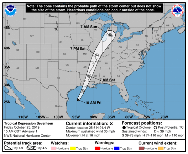
LOCATION…25.6N 94.4W
ABOUT 320 MI…515 KM SSW OF LAKE CHARLES LOUISIANA
MAXIMUM SUSTAINED WINDS…35 MPH…55 KM/H
PRESENT MOVEMENT…N OR 10 DEGREES AT 16 MPH…26 KM/H
MINIMUM CENTRAL PRESSURE…1006 MB…29.71 INCHES
DISCUSSION AND OUTLOOK
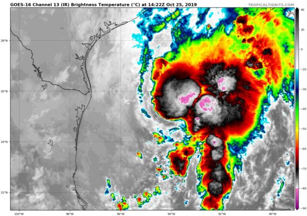
At 1000 AM CDT (1500 UTC), the center of Tropical Depression Seventeen was located near latitude 25.6 North, longitude 94.4 West. The depression is moving toward the north near 16 mph (26 km/h). A motion toward the north-northeast at a faster forward speed is expected this afternoon through Sunday. On the forecast track, the center of the cyclone should move across the northwestern Gulf of Mexico this afternoon and then move over the northern Gulf coast tonight or Saturday morning.
Maximum sustained winds are near 35 mph (55 km/h) with higher gusts. Some strengthening is expected today, and the depression could become a tropical storm this afternoon. The cyclone is then expected to merge with a cold front and become a post-tropical low with gale-force winds tonight before the center reaches the Gulf coast. An Air Force Reserve Hurricane Hunter aircraft is scheduled to investigate the depression this afternoon.
The estimated minimum central pressure is 1006 mb (29.71 inches).
HAZARDS AFFECTING LAND
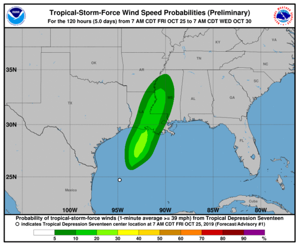
WIND: Gale-force winds associated with this system should spread over portions of the northern Gulf coast tonight and Saturday morning.
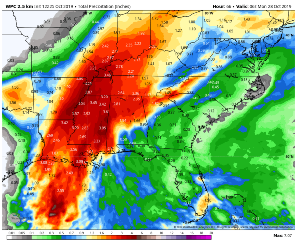
RAINFALL: The depression and rainfall ahead of the system along and north of the frontal boundary across the Central Gulf coast is expected to produce total rainfall accumulations of 2 to 4 inches with maximum totals of 8 inches across the Central Gulf coast into the Lower Mississippi Valley through Saturday morning. These rains may produce flash flooding across the Central Gulf coast into the Lower Mississippi Valley.
COASTAL FLOODING: Above-normal tides and associated coastal flooding are possible across portions of the northern Gulf coast. Please see products from local National Weather Service forecast offices for additional information.
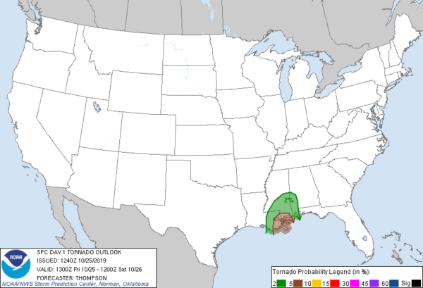
TORNADOES: A couple tornadoes are possible through tonight across southeast portions of Louisiana and Mississippi into southwest Alabama.
Category: Alabama's Weather, ALL POSTS, Tropical
About the Author (Author Profile)
Scott Martin is an operational meteorologist, professional graphic artist, musician, husband, and father. Not only is Scott a member of the National Weather Association, but he is also the Central Alabama Chapter of the NWA president. Scott is also the co-founder of Racecast Weather, which provides forecasts for many racing series across the USA. He also supplies forecasts for the BassMaster Elite Series events including the BassMaster Classic.Subscribe
If you enjoyed this article, subscribe to receive more just like it.


