As Expected, Olga Has Become A Post-Tropical Cyclone
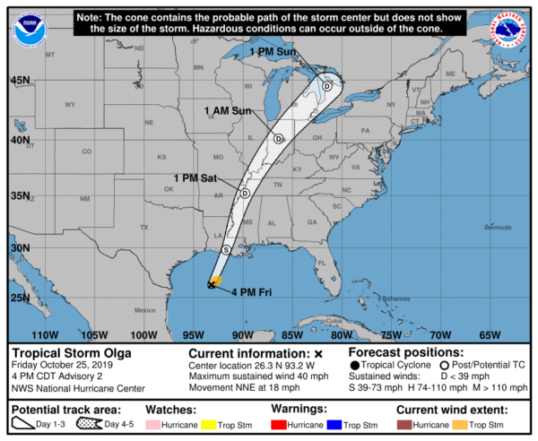
REMNANTS OF OLGA EXPECTED TO BRING HEAVY RAIN AND SEVERE WEATHER TO THE CENTRAL
GULF COAST AND LOWER MISSISSIPPI VALLEY ON SATURDAY.
SUMMARY OF 1000 PM CDT…0300 UTC…INFORMATION
———————————————–
LOCATION…27.8N 92.2W
ABOUT 170 MI…275 KM SSE OF LAKE CHARLES LOUISIANA
MAXIMUM SUSTAINED WINDS…50 MPH…85 KM/H
PRESENT MOVEMENT…NE OR 40 DEGREES AT 17 MPH…28 KM/H
MINIMUM CENTRAL PRESSURE…999 MB…29.50 INCHES
DISCUSSION AND OUTLOOK
———————-
At 1000 PM CDT (0300 UTC), the center of Post-Tropical Cyclone Olga
was located near latitude 27.8 North, longitude 92.2 West. The
post-tropical cyclone is moving toward the northeast near 17 mph (28
km/h). Olga is forecast to move quickly northward to
north-northeastward on Saturday and then turn northeastward late
Saturday or Sunday. On the forecast track, the center of the
post-tropical cyclone will move up the Mississippi Valley tomorrow
and toward the Great Lakes later this weekend.
Maximum sustained winds are near 50 mph (85 km/h) with higher gusts.
Weakening is expected after the cyclone moves over land Saturday
morning.
Tropical-storm-force winds extend outward up to 140 miles (220 km)
from the center.
The estimated minimum central pressure based on earlier data from
an Air Force Reserve hurricane hunter aircraft and surface
observations over the northern Gulf of Mexico is 999 mb (29.50
inches).
HAZARDS AFFECTING LAND
———————-
WIND: Gale-force winds associated with Olga and its remnants should
spread over portions of the northern Gulf coast tonight and Saturday
morning.
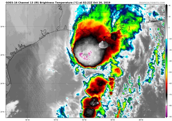
RAINFALL: The post-tropical cyclone, along with rainfall ahead of
the system along and north of the frontal boundary across the
Central Gulf coast, is expected to produce total rainfall
accumulations of 3 to 6 inches with maximum totals of 8 inches
across the Central Gulf coast into portions of the Lower Mississippi
Valley and western Tennessee Valley through Saturday morning. These
rains may produce flash flooding across the Central Gulf coast into
the Lower Mississippi Valley and western Tennessee Valley.
COASTAL FLOODING: Above-normal tides and associated coastal
flooding are possible across portions of the northern Gulf coast.
Please see products from local National Weather Service forecast
offices for additional information.
TORNADOES: Isolated tornadoes are possible tonight into Saturday
morning across parts of southeast Louisiana, southern Mississippi,
and western Alabama.
NEXT ADVISORY
————-
This is the last public advisory issued by the National Hurricane
Center on this system.
About the Author (Author Profile)
Scott Martin is an operational meteorologist, professional graphic artist, musician, husband, and father. Not only is Scott a member of the National Weather Association, but he is also the Central Alabama Chapter of the NWA president. Scott is also the co-founder of Racecast Weather, which provides forecasts for many racing series across the USA. He also supplies forecasts for the BassMaster Elite Series events including the BassMaster Classic.Subscribe
If you enjoyed this article, subscribe to receive more just like it.


