A Quick Late Night Check On Our Weather Situation
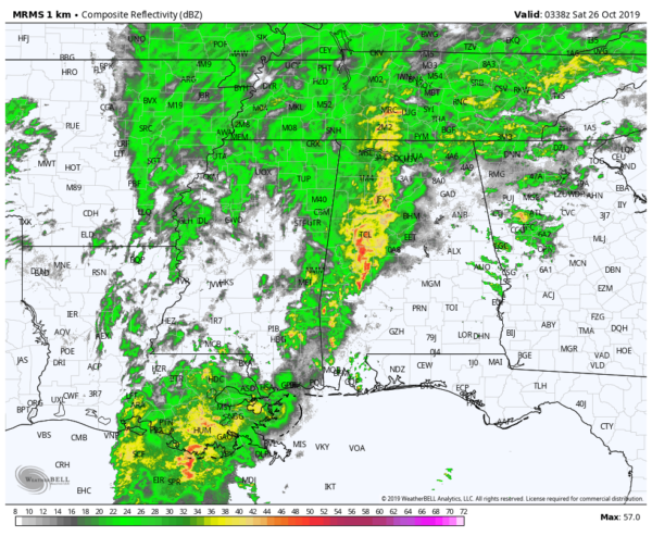
At 10:38 pm, much of the eastern half of Central Alabama is free from any rainfall while much of the activity continues to be on the western side of the area. No severe weather at this time but there continues to be a very small threat of an isolated tornado mainly over Marengo, Dallas, Perry, and Hale counties.
There will also be a threat of some flooding west of a line from Double Springs, to Jasper, to Tuscaloosa, to Linden. A few areas received two to three inches of rain the past 24 hours and an additional few inches are possible overnight.
Flash Flood Watches are up for the western counties of North and Central Alabama until 10:00 am on Saturday morning.
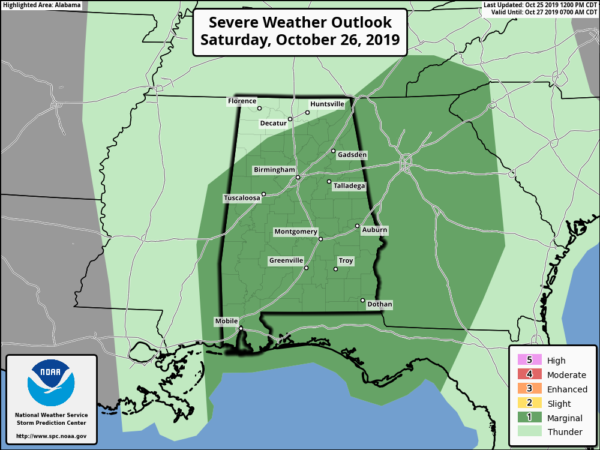
The Storm Prediction Center continues to have nearly all of Central Alabama in a Marginal Risk of severe storms throughout nearly the entire day on Saturday. The main threats will be from a few brief tornadoes and damaging wind gusts up to 60 MPH. The main window for stronger to severe storms will be from 10:00 am to 10:00 pm (10:00 am to 3:00 pm for the western-third of the area, 1:00 pm to 6:00 pm for the central-third, and 4:00 pm to 10:00 for the eastern-third). We will also have breezy conditions with some wind gusts of 30-40 MPH possible especially ahead and at frontal passage.
Category: Alabama's Weather, ALL POSTS, Severe Weather
About the Author (Author Profile)
Scott Martin is an operational meteorologist, professional graphic artist, musician, husband, and father. Not only is Scott a member of the National Weather Association, but he is also the Central Alabama Chapter of the NWA president. Scott is also the co-founder of Racecast Weather, which provides forecasts for many racing series across the USA. He also supplies forecasts for the BassMaster Elite Series events including the BassMaster Classic.Subscribe
If you enjoyed this article, subscribe to receive more just like it.


