

A Brief Check On Our Weather At Midday
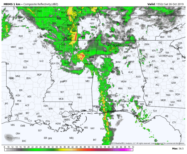
Currently, we have showers that are moving across the southwestern parts of the area that is moving into a highly sheared environment. The good news is that instability remains too low at this time for the development of any strong to severe storms.
No watches or warnings are currently in effect for anyone in Central Alabama, but there is a large severe thunderstorm warning in effect for parts of northeast Mississippi until 11:15 am for the threat of damaging winds up to 60 MPH.
With the heating of the day and low-level advection out ahead of the cold front, instability values will rise. With the highly sheared environment, a brief tornado or two along with isolated damaging wind gusts up to 60 MPH remain possible.
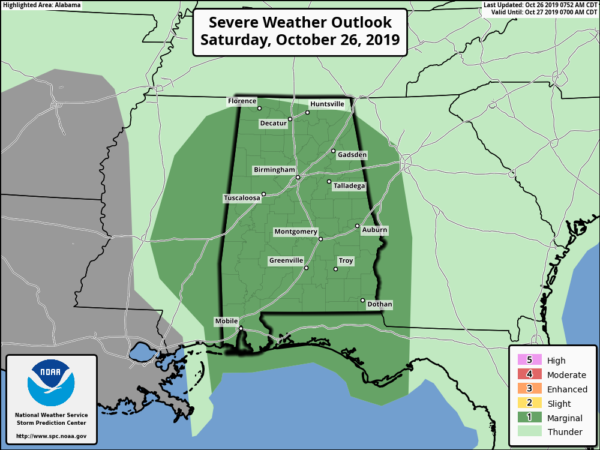
We still remain in a Marginal Risk of severe storms across the area with the main window being from now through 10:00 pm tonight. For the western third of the area, that will be from now through 3:00 pm. For the central-third, that will be from 1:00 pm to 6:00 pm. For the eastern-third, that will be from 4:00 pm to 10:00 pm.
A Wind Advisory remains in effect for nearly all of Central Alabama until 5:00 pm tonight as winds of 10-20 MPH will be likely with non-thunderstorm gusts up to 40 MPH possible with the tightening pressure gradient with the remnants of Olga passing to our northwest.
Category: Alabama's Weather, ALL POSTS, Severe Weather
About the Author (Author Profile)
Scott Martin is an operational meteorologist, professional graphic artist, musician, husband, and father. Not only is Scott a member of the National Weather Association, but he is also the Central Alabama Chapter of the NWA president. Scott is also the co-founder of Racecast Weather, which provides forecasts for many racing series across the USA. He also supplies forecasts for the BassMaster Elite Series events including the BassMaster Classic.Subscribe
If you enjoyed this article, subscribe to receive more just like it.


