Sunday Weather Xtreme Video: Clearing Today, Perfect Tomorrow, Rain Returns for Midweek
Good morning! Our energetic storm system, charged up by the remnants of Tropical Storm Olga, is moving through eastern Great Lakes and into the Northeast this morning. Winds diminished late yesterday and the rains moved out, setting the stage for a couple of nice days, including one nearly perfect one tomorrow. Let’s dive deeper into the details.
BENEFICIAL RAINS: Short term moisture needs are finally caught up across much of Alabama after a fairly good soaking Friday and Friday night. 2-4 inches of rain was widespread across the northern half of the state, with widespread 5+ inch amounts over the western third of the state, from northern Mobile and Washington Counties in Southwest Alabama up to northwestern Walker and Tuscaloosa Counties. Throw in another one half to one inch yesterday, and we at least dented the drought.
STILL NEED MORE RAIN: Parts of Central Alabama still need more rainfall though to drive a stake through the heart of this little flash drought. Here are the long term rainfall needs to bring the Palmer Index back to near normal conditions:
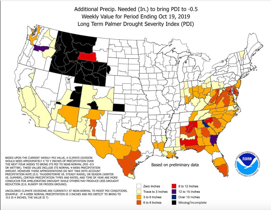
This doesn’t include yesterday and Friday’s rainfall, of course, which probably ended the drought for West Alabama. But places like Shelby, Chilton, Coosa, Tallapoosa, Jackson, and DeKalb Counties could use 5-10 more inches.
WINDS: A strong low-level jet of some 70-80 knots formed on the eastern side of the low-pressure system that was Olga as it moved up through Mississippi. Widespread 25-45 mph wind gusts were observed over eastern Mississippi and western Alabama. Numerous trees were reported down in several areas, especially Northwest Alabama’s Marion County. Blount County also experienced numerous downed trees.
MOVING AHEAD: Clouds are dominating the sky across much of the area the morning, caused by leftover low-level moisture. Sunshine will gradually erode the clouds, with the help of some drier air infiltrating the backside of the upper-level low. Highs today will manage to rise into the upper 60s along with a light northwesterly wind. Lows tonight will drop into the upper 40s to near 50F.
PERFECT WEATHER WATCH: I am going ahead and calling it for Monday. Mostly sunny, to at least partly cloudy skies, temperatures in the middle and upper 70s and a light wind shifting to southerly during the day, and you have the makings of a perfect weather day. Try to enjoy it, because the clouds will return Monday night.
FRONT RETURNING: A strong southwesterly flow aloft and developing low over the ArkLaTex will bring the former boundary from the weekend back to the north as a warm front. Showers will find their way back into Alabama by late Monday night into Tuesday. Rain chances will be with us through much of Tuesday. Look for an even better chance on Wednesday as the front slowly meanders to the north. approaches from the west. Highs will be in the 70s both days. Lows will be in the 50s and 60s.
WEEKEND OUTLOOK: The slow-moving front will clear the area by Friday morning, with clearing skies and cooler conditions as high pressure builds in. The weekend will be fair and cool, with highs in the lower 60s and lows in the 30s and lower 40s.
VOODOO COUNTRY: After a week off from rain, it looks like a fairly strong front will bring more rain and storms to Alabama by the following Thursday and Friday, November 7th and 8th. The system doesn’t have much of a severe weather look for now.
GULF COAST WEATHER: Like here, Monday will be perfect with lots of sunshine and highs in the upper 70s, but rain returns to the beautiful beaches of Alabama and Northwest Florida There will be a few periods of rain between then and late Thursday night. It won’t rain all the time, but rain chances will be pretty high. Expect sunny but cooler conditions for the beach over the weekend, with highs in the 60s and lows in the 50s. Water temperatures are running about 72 degrees. 3-6 foot waves and high risk of rip currents today, but things will improve starting tonight, with seas returning to around 1 foot through Tuesday. Click here to see the Beach Forecast Center page.
TROPICS: Tropical Storm Pablo is accelerating away from the Azores in the far northeastern Atlantic this morning. The system nearly became a hurricane yesterday, but will begin weakening tonight and will become post-tropical by Monday. No other systems threaten to become tropical cyclones in the Atlantic basin over the next two weeks.
WEATHERBRAINS: This week, the panel will entertain prominent TV Met and former National Weather Association President Alan Sealls. Check out the show at www.WeatherBrains.com. You can also subscribe on iTunes. You can watch the show live at live.bigbrainsmedia.com You will be able to see the show on the James Spann 24×7 weather channel on cable or directly over the air on the dot 2 feed.
ON THIS DATE IN 2008: For the first time in history, a World Series game was suspended. Major League Baseball, in conjunction with the leadership of the Phillies and Rays, had apparently reached a decision a few days before that no game of the 2008 Series would be called because of rain as provided for in the rules. Rain delayed Game Three on Saturday, October 25 by over an hour and a half, resulting in a game that did not start until after 10 p.m. and did not finish until after 1:30 a.m. With rain threatening Game Five on Monday the 27th, MLB decided to go ahead and play the game. The temperature at game time was 43F and a light rain began falling during the game. The rain got heavier and heavier until the tarp was pulled during the 6th inning, right after Tampa Bay had tied the game 2-2. The game was suspended a short time later. Follow my weather history tweets on Twitter. I am @wxhistorian at Twitter.com.
Category: Alabama's Weather, ALL POSTS
About the Author (Author Profile)
Bill Murray is the President of The Weather Factory. He is the site's official weather historian and a weekend forecaster. He also anchors the site's severe weather coverage. Bill Murray is the proud holder of National Weather Association Digital Seal #0001 @wxhistorianSubscribe
If you enjoyed this article, subscribe to receive more just like it.


