Mid-Afternoon Check On Our Weather
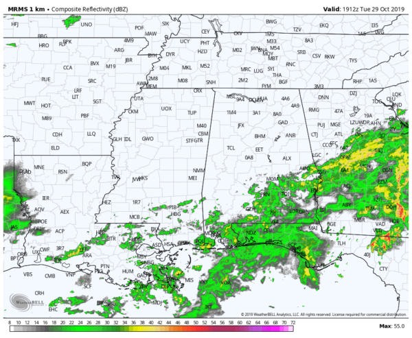
As of 2:15 pm, skies are mostly cloudy across nearly all of Central Alabama with the exception of a few thinner clouds that is allowing for some sunshine to make it to the surface. All rainfall is currently occurring over the extreme southeastern corner of the area south of the I-85 corridor. Temperatures are in the lower 60s to the mid-70s across the area. Birmingham was at 66 degrees. Haleyville was at 61 degrees as the cool spot. Uniontown was the warm spot at 75 degrees.
Clouds will continue to increase across the area for the rest of the daylight hours with rain likely along and south of the I-85 corridor. Rain chances drop as you move northwest… 50% for locations alond a line from Selma to Alexander City, down to 20% along the I-59/20 and I-20 corridors. North of that, it should remain dry. Highs will top out in the lower to mid-70s across the area.
Rain chances will continue to increase across all of Central Alabama during the late night and overnight hours ranging from 40% to 80% from north to south. When it is not raining, skies will be mainly cloudy. Lows will be in the upper 50s to the mid-60s.
Wednesday looks to be a wet day across all of Central Alabama with the exception of the southeastern corner where rain chances will be a little less. A few claps of thunder will be possible and a stronger storm can’t be ruled out in the northwest. There will be breaks in the rain, but you can expect it to rain at any time. Highs will be in the 70s across the area, with rain chances in the 60% to 80% range from southeast to northwest.
Category: Alabama's Weather, ALL POSTS
About the Author (Author Profile)
Scott Martin is an operational meteorologist, professional graphic artist, musician, husband, and father. Not only is Scott a member of the National Weather Association, but he is also the Central Alabama Chapter of the NWA president. Scott is also the co-founder of Racecast Weather, which provides forecasts for many racing series across the USA. He also supplies forecasts for the BassMaster Elite Series events including the BassMaster Classic.Subscribe
If you enjoyed this article, subscribe to receive more just like it.


