Morning Update For The Severe Storm Potential Tonight Through The Overnight Hours
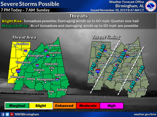
NWS Birmingham has now updated the severe storm risk for tonight through the overnight hours to include a Slight Risk for severe storms over the western parts of the area (west of a line from Cullman to Northport to Demopolis. The rest of Central Alabama still remains in a Marginal Risk for severe storms.
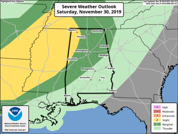
This now closely matches what the Storm Prediction Center put out this morning with the exception of the southeastern parts of the area. Damaging winds up to 60 MPH and brief spin-up tornadoes are possible, with large hail possible in the Slight Risk locations.
While the timing across the area is a little broad due to the uncertainty of the speed that the activity will move through, here is the breakdown of what to expect:
• 7:00 pm to midnight: west of a line from Holly Pond to Tuscaloosa to Forkland
• 10:00 pm to 3:00 am: west of a line from Ranburne to Alexander City to Montgomery
• 1:00 am to 7:00 am: east of a line from Ranburne to Alexander City to Montgomery
If any severe weather watches are issued they will more than likely be tornado watches, especially for the western half of the area. We’ll have to wait and see how it goes tonight.
The reason for the change in thinking for the severe storm threat and increasing the risk levels in the west is the amount of sunshine that is occurring over Central Alabama and back into Mississippi. Any extra sunshine will allow the atmosphere to heat a few degrees warmer than expected and will allow for instability levels to increase a little more rapidly throughout the day. This may also allow for some supercells to develop out just ahead of the main squall line which could affect the western parts of the area (Slight Risk locations).
We will already have a good bit of wind shear and helicity in place, and with instability values forecast to approach the 600 J/kg level, that will increase the probability of severe storms. We’ll have to watch and see if the extra sunshine adds to those forecasted instability values.
Also, a Wind Advisory may be issued as non-severe thunderstorm winds will be gusty and we could see gusts exceeding 40 MPH along and ahead of the main squall line and cold front.
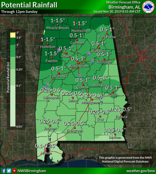
Expected rainfall amounts across Central Alabama look to range from 1/4-inch in the southeastern parts of the area to as high as 1 1/2-inches over the northwestern parts. With the amount of leaves that have fallen, there could be some flash flooding issues mainly in poor drainage areas, but not expected elsewhere.
Much, if not all of the activity, will be out of Central Alabama by 9:00 am Sunday and skies will begin to clear out from northwest to southeast. Cooler air will take a while to work into the area after frontal passage, but winds will remain breezy at times with possible gusts up to 30 MPH for a little while. Sunday’s highs will be up in the mid-50s to the mid-60s.
Category: Alabama's Weather, ALL POSTS, Severe Weather
About the Author (Author Profile)
Scott Martin is an operational meteorologist, professional graphic artist, musician, husband, and father. Not only is Scott a member of the National Weather Association, but he is also the Central Alabama Chapter of the NWA president. Scott is also the co-founder of Racecast Weather, which provides forecasts for many racing series across the USA. He also supplies forecasts for the BassMaster Elite Series events including the BassMaster Classic.Subscribe
If you enjoyed this article, subscribe to receive more just like it.


