

Latest Mesoscale Discussion & Severe Weather Outlook For The Area
The severe weather threat for Tornado Watch 698 continues.
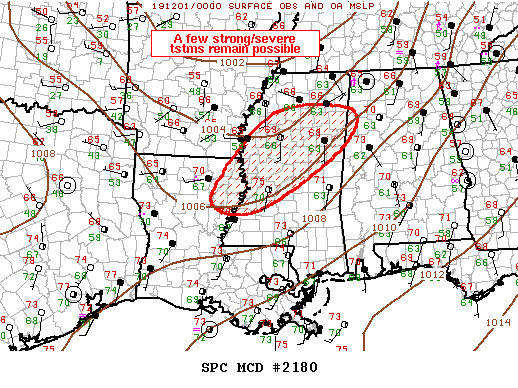
SUMMARY: A few strong/severe storms will spread across the Tornado Watch locations over the next few hours.
DISCUSSION: The southern fringe of large-scale forcing for ascent is spreading across the mid-South and this appears influential in the maintenance of several bands of pre-frontal convection. While this convection has persisted for some time, the latest radar data does not exhibit appreciable storm-scale organization. Overall trends have actually decreased over the last hour or so but environmental shear remains supportive of supercells. Earlier CAMs guidance suggests a downward trend this evening, supported by current radar imagery. Despite these issues, there remains some low-end potential for an isolated tornado or localized damaging wind gust.
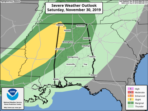
The latest Severe Weather Outlook update was just released and the SPC keeps a Slight Risk for severe storms up for the west and northwestern parts of the area and a Marginal Risk up for most of the rest of Central Alabama through tonight and the overnight hours.
Category: Alabama's Weather, ALL POSTS, Severe Weather
About the Author (Author Profile)
Scott Martin is an operational meteorologist, professional graphic artist, musician, husband, and father. Not only is Scott a member of the National Weather Association, but he is also the Central Alabama Chapter of the NWA president. Scott is also the co-founder of Racecast Weather, which provides forecasts for many racing series across the USA. He also supplies forecasts for the BassMaster Elite Series events including the BassMaster Classic.Subscribe
If you enjoyed this article, subscribe to receive more just like it.


