Skies Clear Out Today, Rain Returns By The End Of The Week
TODAY
After the last remaining showers move out of the area this morning, skies will clear out and we’ll be left with a sunny day. Afternoon highs will get up into the mid-50s to the upper 60s across the area from northwest to southeast. Clouds will move back in over the northern parts of the area, but the southern half will remain mostly clear. Lows will be in the 30s.
MONDAY
The start of the workweek will be a much cooler day as the cold air finally makes it in here after the passage of the cold front that moved through during the pre-dawn hours this morning. Clouds will gradually decrease across the area and highs will top out in the lower 40s to just at 50 degrees.
TUESDAY & WEDNESDAY
Tuesday will be dry with mostly clear skies throughout the daylight hours, but a few clouds may move in during the evening hours over the northern parts of the area. Highs will be just a touch warmer, topping out in the lower to mid-50s. The warming trend continues on Wednesday as we’ll have plenty of sunshine with highs topping out in the mid-50s to the lower 60s.
THURSDAY & FRIDAY
A quick-moving low will move toward and into the southeast on Thursday that will bring an increase of clouds during the latter part of the day. Prior to that, skies will be mostly sunny with highs reaching the upper 50s to the mid-60s. Showers associated with the low will begin to move into the area just after midnight and will bring a decent chance of rain throughout the morning and into the early afternoon hours on Friday. Highs will be in the mid-50s to the lower 60s.
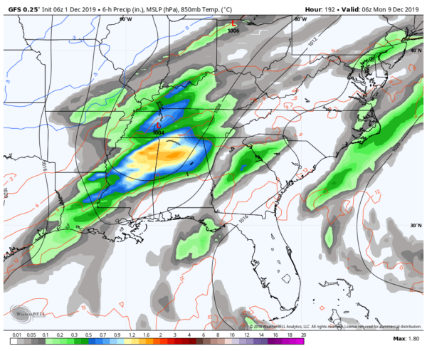
GFS valid at 12:00 am on Monday, December 9th.
NEXT WEEKEND
We’ll have some sunshine to start off the day on Saturday before clouds move back in as another system looks to move in and bring rain and thunderstorms to the area late on Sunday and through much of the morning on the following Monday. We may have to watch this system as the low will be much closer to Central Alabama than the previous systems and strong storms may be possible. It is still too far out at this point and it all may change before we get there. Saturday’s highs will be in the mid-50s to the lower 60s and warming into the 60s to close to 70 degrees on Sunday.
Category: Alabama's Weather, ALL POSTS, Weather Xtreme Videos
About the Author (Author Profile)
Scott Martin is an operational meteorologist, professional graphic artist, musician, husband, and father. Not only is Scott a member of the National Weather Association, but he is also the Central Alabama Chapter of the NWA president. Scott is also the co-founder of Racecast Weather, which provides forecasts for many racing series across the USA. He also supplies forecasts for the BassMaster Elite Series events including the BassMaster Classic.Subscribe
If you enjoyed this article, subscribe to receive more just like it.


