Mainly Dry Today With A Few Sprinkles Possible Early; Severe Storm Potential On Monday
TODAY
We’ll have mostly cloudy skies throughout the day today with a few sprinkles possible at times over the northern parts of the area during the morning. By afternoon, we could see a few breaks in those clouds to let a little sunshine through at times. Afternoon highs will be in the lower 50s to near 60 degrees across the area.
SUNDAY
Skies look to be mostly cloudy throughout much of the day on Sunday, but we could see some of those clouds move out for a little while during the latter half of the day. We’ll be dry with afternoon highs reaching the upper 50s to the upper 60s.
MONDAY
We’ll start off the day on Monday with mostly cloudy skies across the area but we’ll have a low stationed over Arkansas that will be bringing a strong cold front with that will move through setting the stage for the potential of strong to severe storms during the afternoon through the evening and late-night hours.
Ahead of the front, warm and moist air will be pulled into the area from the south that will begin to destabilize the atmosphere over Central Alabama. We could see some shower activity start as early as the mid to late morning hours over the western parts of the area, with the front beginning to move in during the late evening hours. Afternoon highs look to top out in the upper 60s to the mid-70s.
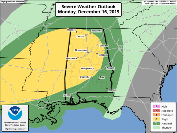
The Storm Prediction Center has nearly all of Central Alabama in a Slight Risk for severe storms throughout the day on Monday with the exception of the extreme eastern parts of the area. All modes of severe weather look to be possible: tornadoes, damaging winds up to 60 MPH, and hail up to 1-inch in diameter. At this point, the timing for strong to severe storms will be from 2:00 pm Monday afternoon to 2:00 am on Tuesday morning. The higher resolution models are just now starting to come into view, so we’ll have a better grasp on the timing and other details starting this evening.
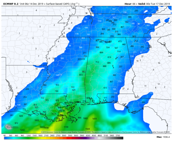
European Model CAPE values valid at 6:00 pm Monday.
Global models have been showing that we’ll have decent surface-based instability, strong shear, and higher helicity values in place over Central Alabama. It is just too early to know at this point if all of the activity will move through as a squall line or if we’ll have discrete supercells form out ahead of the squall line. We’ll keep you updated throughout the weekend.
TUESDAY
On Tuesday, the front will be moving out of the state during the morning hours along with any shower activity associated with it. High temperatures for the day will probably occur at 12:00 am as the colder air moves into the state. Temperatures will be in the mid-40s to the upper 50s during the afternoon with clouds slowly clearing out of the area.
WEDNESDAY
Wednesday will be a cool day across Central Alabama with maximum sunshine. Winds will be out of the north as a high will be located over the eastern parts of Arkansas pulling that colder continental air into the area. Highs will top out in the mid-40s to the lower 50s.
THURSDAY
We’ll continue to be under the influence of high pressure that will be centered off to our southwest on Thursday, which will keep our weather dry and cool across Central Alabama. We’ll start off with sunny skies, but clouds will begin to move in during the late morning and into the afternoon. Highs will be in the lower to mid-50s.
FRIDAY
The high breaks down and we’ll begin to see some moisture move into Central Alabama throughout the day on Friday. Some showers look to be possible during the afternoon hours, but those rain chances look small at this point. Highs will be in the lower 50s to near 60 degrees across the area.
Category: Alabama's Weather, ALL POSTS, Severe Weather, Weather Xtreme Videos
About the Author (Author Profile)
Scott Martin is an operational meteorologist, professional graphic artist, musician, husband, and father. Not only is Scott a member of the National Weather Association, but he is also the Central Alabama Chapter of the NWA president. Scott is also the co-founder of Racecast Weather, which provides forecasts for many racing series across the USA. He also supplies forecasts for the BassMaster Elite Series events including the BassMaster Classic.Subscribe
If you enjoyed this article, subscribe to receive more just like it.


