Latest Mesoscale Discussion From SPC, Tornado Threat Continues
Areas affected…Southeast Mississippi and western Alabama
Concerning…Tornado Watch 702…
Valid 170157Z – 170330Z
The severe weather threat for Tornado Watch 702 continues.
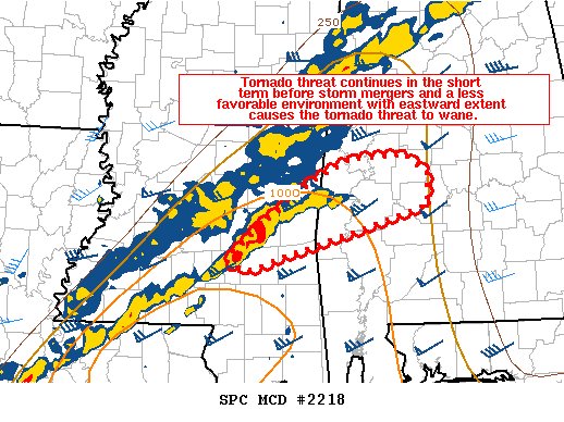
SUMMARY…The tornado threat continues in the short term before storm mergers and a less favorable environment with eastward extent causes the tornado threat to wane.
DISCUSSION…Several supercells are ongoing in southeast Mississippi and western Alabama. At least one of these supercells (southern Sumter county) is likely still producing a tornado as of 150Z. These storms remain in a favorable environment slightly ahead of the linear convection along the front, but this line will gradually overtake the convection within the next 1 to 2 hours which should lower the tornado threat. In addition, as these storms move east, they will encounter a gradually more stable airmass (250 J/kg MLCAPE at BMX 00Z RAOB). This will also assist in the reduction of the tornado threat. Despite the less favorable environment with time, there is still a significant tornado threat in the short term with MLCAPE around 1000 J/kg and SRH around 350 to 400 m2/s2 per RAP mesoanalysis.
Category: ALL POSTS
About the Author (Author Profile)
Scott Martin is an operational meteorologist, professional graphic artist, musician, husband, and father. Not only is Scott a member of the National Weather Association, but he is also the Central Alabama Chapter of the NWA president. Scott is also the co-founder of Racecast Weather, which provides forecasts for many racing series across the USA. He also supplies forecasts for the BassMaster Elite Series events including the BassMaster Classic.Subscribe
If you enjoyed this article, subscribe to receive more just like it.


