

A Few Showers Possible Today; Potential For Strong To Severe Storms On Sunday
Today
Today will be a relatively gloomy-looking day across Central Alabama as skies will be mainly cloudy throughout the entire day. The low that will be bringing a cold front through our area on Sunday will be over southern parts of Kansas at noon, but that opens the express of warm and moist air to flow in over us. We’ll have a few isolated to scattered showers moving across the area today, but the overall rain chance for any location will be around 30%. Highs will top out in the upper 60s to the lower 70s.
Sunday
On Sunday morning, the center of the low will be located on the Minnesota/Iowa state line and will move slowly eastward through the day. The trailing cold front will approach the area but will not move into Central Alabama until late on Sunday evening. Out ahead of the front, warm and moist air will be pulled up from the Gulf of Mexico, which will allow instability values to rise during the heating of the day. We can expect widespread showers and thunderstorms across all of Central Alabama during the afternoon and evening hours, with the potential of a few of those storms to become strong to severe. Highs will be in the lower to mid-70s.
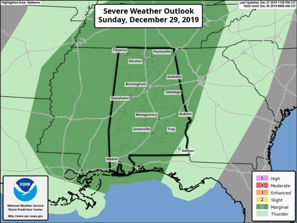
The Storm Prediction Center has all of Central Alabama in a Marginal Risk for severe storms throughout the day on Sunday. A brief tornado and damaging winds up to 60 MPH will be possible. We could also see a few localized flash flooding issues in poor drainage areas. The main window for strong to severe storms looks to be from 12:00 pm Sunday through 12:00 am Monday.
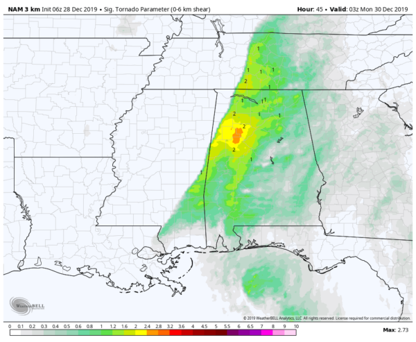
Significant Tornado Parameter valid at 9:00 pm Sunday (06z NAM 3k).
The latest run of the high-resolution NAM shows that there will be ample amounts of wind shear and helicity out ahead and along with the cold front. There is a meager amount of surface-based instability being forecast at this point, which could be the limiting factor. But we have to remember that it doesn’t take much instability with these winter systems to get stronger to severe storms. We are also seeing Significant Tornado Parameters approaching 3.0 in the west-central parts of the area.
As said earlier, instability may be the limiting factor as the amount of cloud cover and pre-frontal rain may hamper the destabilization of the atmosphere. If we have any sunshine, instability values will be able to rise.
Monday
Rain should be out of the area before sunrise on Monday and skies will clear out nicely. We’ll end up with mostly sunny skies with much cooler temperatures. Highs look to top out in the mid-50s to the mid-60s.
New Year’s Eve
High pressure will be moving in our direction from the west which will keep us cool and dry for the final day of the decade. We may have a few clouds float in at times, but skies should stay mostly clear. Highs will be in the 50s across the area and dropping into the mid-30s to the lower 40s around midnight.
Happy New Years
Skies on the first day of the 2020s will be partly cloudy to start, but those clouds will be on the increase throughout the day. We look to stay dry and cool with afternoon highs reaching the mid to upper 50s.
Thursday
On Thursday, moisture will be flowing up into Central Alabama from the southwest with the next disturbance which looks to bring heavy rain and maybe a few thunderstorms. This doesn’t look to have any severe weather associated with it, but we could see some localized flash flooding issues before this system is out of here. Highs will be in the lower 50s to the mid-60s.
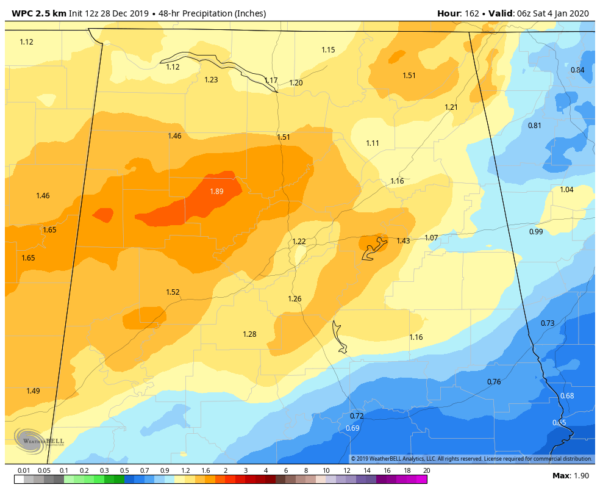
48 hour rainfall forecast valid from 12:00 am Thursday to 12:00 am Saturday.
Friday
Rain and a few thunderstorms will continue through much of the day on Friday, with rainfall being heavy at times. The latest projections show two-day rainfall totals in the 1.00-2.00 inch range across the area with the heaviest totals over the northwestern parts of Central Alabama. No severe weather is expected at this time across the area, but there may be some stronger storms across the Gulf Coast. Highs will be in the lower 50s to the mid-60s.
Beach Forecast
Get the latest weather and rip current forecasts for the beaches from Bay St. Louis, MS, to Panama City Beach, FL, on our Beach Forecast Center page. There, you can select the forecast of the region that you are interested in.
Advertise With The Blog!
After a record-setting 2018 with nearly 20 million page views, AlabamaWx.com is already well on its way to another great year as we’ve just topped 16.6 million page views so far in 2019! Don’t miss out! We can customize a creative, flexible and affordable package that will suit your organization’s needs. Contact Bill Murray at (205) 687-0782.
E-Forecast
Get the Alabama Wx Weather Blog’s Seven-Day Forecast delivered directly to your inbox by email twice daily. It is the most detailed weather forecast available in Central Alabama. Subscribe here… It’s free!
Connect With The Blog On Social Media
You can find the AlabamaWx Weather Blog on the major social media networks:
Facebook
Twitter
Instagram
WeatherBrains
Don’t forget you can listen to our weekly 90 minute netcast anytime on the web at WeatherBrains.com or on Apple Podcasts, Stitcher, or Spotify. This is the show all about weather featuring many familiar voices, including the meteorologists at ABC 33/40.
Category: Alabama's Weather, ALL POSTS, Severe Weather, Weather Xtreme Videos
About the Author (Author Profile)
Scott Martin is an operational meteorologist, professional graphic artist, musician, husband, and father. Not only is Scott a member of the National Weather Association, but he is also the Central Alabama Chapter of the NWA president. Scott is also the co-founder of Racecast Weather, which provides forecasts for many racing series across the USA. He also supplies forecasts for the BassMaster Elite Series events including the BassMaster Classic.Subscribe
If you enjoyed this article, subscribe to receive more just like it.


