A Quick Check On Our Weather Situation Just Before 7:00 PM; Risks Have Been Trimmed Some
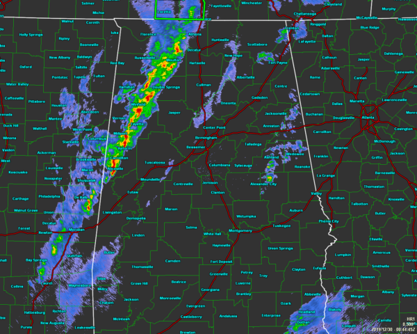
At 6:45 PM, a line of strong thunderstorms continues to push eastward across the west and northwestern parts of North/Central Alabama. No active warnings are in effect at this point, but we’ve had a few issued over the past couple of hours.
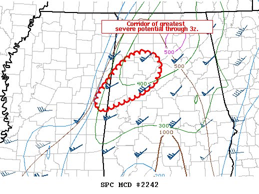
As of the latest Mesoscale Discussion from the Storm Prediction Center, the greatest potential for any severe storms are over the northwestern portions of Central Alabama. This is where we will need to watch to see if any segments in the line start to bow or we get any small circulations to start to pop up. Isolated damaging winds up to 60 MPH and a brief spinup tornado remains possible.
The main window for stronger to severe storms continues until midnight tonight.
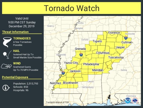
A Tornado Watch continues until 9:00 pm tonight for Colbert, Cullman, Franklin, Lauderdale, Lawrence, Limestone, Morgan, Fayette, Greene, Lamar, Marion, Pickens, Sumter, Tuscaloosa, Walker, and Winston counties in North/Central Alabama. It probably won’t be too long before some counties can be removed from the watch.
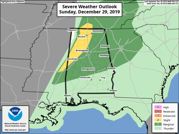
The severe weather risks throughout the rest of tonight have been trimmed as of the latest update from the Storm Prediction Center. For locations behind the line of storms, the threat has ended for the night. Locations out ahead to a line stretching from Huntsville (Madison Co.) to Sumiton (Walker Co.) to Gainesville (Sumter Co.) remain in a Slight Risk (level 2 of 5) for severe storms through the rest of the night. The rest of North/Central Alabama remains in a Marginal Risk (level 1 of 5) with the exception of those locations just south of a line stretching from Gordonville (Lowndes Co.) to Pike Road (Montgomery Co.) to Smiths Station (Lee Co.).
Category: Alabama's Weather, ALL POSTS, Severe Weather
About the Author (Author Profile)
Scott Martin is an operational meteorologist, professional graphic artist, musician, husband, and father. Not only is Scott a member of the National Weather Association, but he is also the Central Alabama Chapter of the NWA president. Scott is also the co-founder of Racecast Weather, which provides forecasts for many racing series across the USA. He also supplies forecasts for the BassMaster Elite Series events including the BassMaster Classic.Subscribe
If you enjoyed this article, subscribe to receive more just like it.


