Much Cooler At Midday, But Plenty Of Sunshine
Skies have cleared out very nicely as of 11:00 am across Central Alabama, with only a few small clouds dotting the skies along and in-between the I-59 and I-20 corridors in the northeastern parts of the area. Temperatures are not that bad at the moment as we see 50s for most locations across the area. The only location that is still in the 40s is Haleyville at 46 degrees. Troy is the warm spot at 58 degrees. Birmingham was sitting at 51 degrees.
Other than the temperatures being much cooler than Sunday, there is not really anything to complain about in the weather department (other than it’s Monday). Skies will be sunny through the rest of the day with afternoon highs reaching the lower 50s to the lower 60s across the area from northwest to southeast. For tonight, we’ll have clear skies and the overnight lows will be back down to what we expected for this time of the year, dropping into the mid to upper 30s.
For New Year’s Eve, it continues to look like a fantastic but cool day across Central Alabama. We’ll have maximum sunshine throughout the day with highs reaching the lower 50s to the lower 60s. For the night time leading up to the strike of midnight and the official start of 2020, skies will be mainly clear with temperatures dipping down into the mid to upper 30s for most with lower 30s in the northeastern parts of the area.
Big Rain Event On Thursday
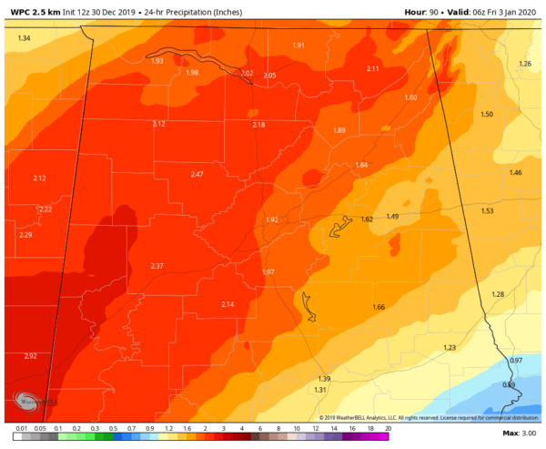
Projected 24-hour rainfall totals from 12am Thursday to 12am Friday (WPC).
North/Central Alabama looks to be in line to receive some heavy rainfall totals throughout the entire day on Thursday as we will have a system moving up from the southwest with plenty of Gulf moisture with it. This latest update from the WPC office shows the potential for 1-3 inches across the area. With the saturated nature of the soil with all of the rain we have received in December, we could have some flash flooding issues. If you are going to the Birmingham Bowl, expect rain throughout the game with some of it being heavy at times. No severe weather is expected, but there may be a few claps of thunder thrown in.
On This Day In Weather History
2008 – Severe to extreme drought was observed across parts of the Hawaiian Islands, the western continental U.S., and parts of Georgia and South Carolina. Meanwhile, severe to exceptional drought conditions were present across southern Texas.
Category: Alabama's Weather, ALL POSTS
About the Author (Author Profile)
Scott Martin is an operational meteorologist, professional graphic artist, musician, husband, and father. Not only is Scott a member of the National Weather Association, but he is also the Central Alabama Chapter of the NWA president. Scott is also the co-founder of Racecast Weather, which provides forecasts for many racing series across the USA. He also supplies forecasts for the BassMaster Elite Series events including the BassMaster Classic.Subscribe
If you enjoyed this article, subscribe to receive more just like it.


