Clearing Afternoon Sky
We started the day off with lingering clouds and light spotty showers, but as we roll into the afternoon, the showers are all but out of here and the sky is clearing, and we should see ample sunshine across the state the rest of the afternoon.
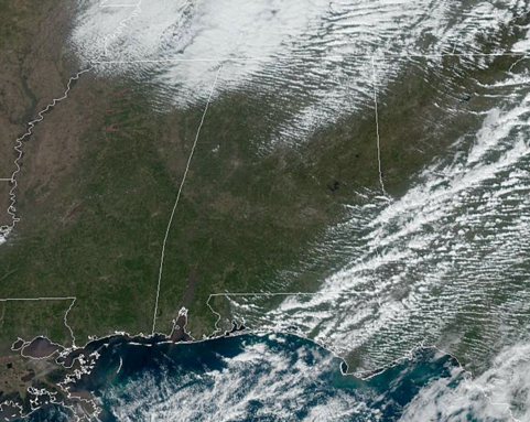
Drier air is flowing into the state, and our winds are quite blustery out of the northwest at 15-25 mph with some higher gusts. Temperature have been dropping since midnight as the cooler air flows into the state, but we should see temperatures at least hold in the lower 50s for a few hours this afternoon due to the sunshine as we finally begin to dry out.
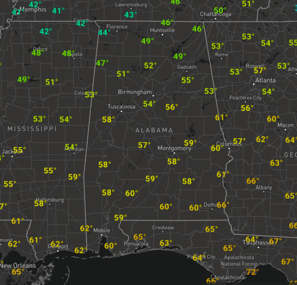
COLD NIGHT AHEAD: A clear sky tonight will allow our temperatures to fall well down into the lower 30s overnight, with most locations expecting to be just below the freezing mark, and yes there will be some upper 20s on the maps by first thing tomorrow morning. Winds will remain a little brisk tonight as well, which will make it feel colder.
SUNDAY/MONDAY: These two days will be dry and feature more sunshine than clouds. Highs tomorrow will be in the mid 50s across North/Central Alabama. Sunday night will be cold, with lows in the upper 30s. Our winds will switch around from the southwest and this will lead to warming temperatures on Monday with lower 60s expected. By Monday afternoon, clouds will be increasing as moisture levels begin to rise.
BEACH FORECAST CENTER: Get the latest weather and rip current forecasts for the beaches from Fort Morgan to Panama City on our Beach Forecast Center page. There, you can select the forecast of the region that you are interested in visiting.
WORLD TEMPERATURE EXTREMES: Over the last 24 hours, the highest observation outside the U.S. was 118.8F at Penrith, Australia. The lowest observation was -65.7F at Summit, Greenland.
CONTIGUOUS TEMPERATURE EXTREMES: Over the last 24 hours, the highest observation was 89F near Immokalee, FL. The lowest observation was -11F at Alamosa, CO.
WEATHER ON THIS DATE IN 1982: Milwaukee, WI, was shut down completely as a storm buried the city under 16 inches of snow in 24 hours. It was the worst storm in thirty-five years.
Category: Alabama's Weather, ALL POSTS
About the Author (Author Profile)
Macon, Georgia Television Chief Meteorologist, Birmingham native, and long time Contributor on AlabamaWX. Stormchaser. I did not choose Weather, it chose Me. College Football Fanatic. @Ryan_StinnetSubscribe
If you enjoyed this article, subscribe to receive more just like it.


