A Nice Sunday; A Few Showers Monday Night; Another Soaking Rain Friday and Friday Night
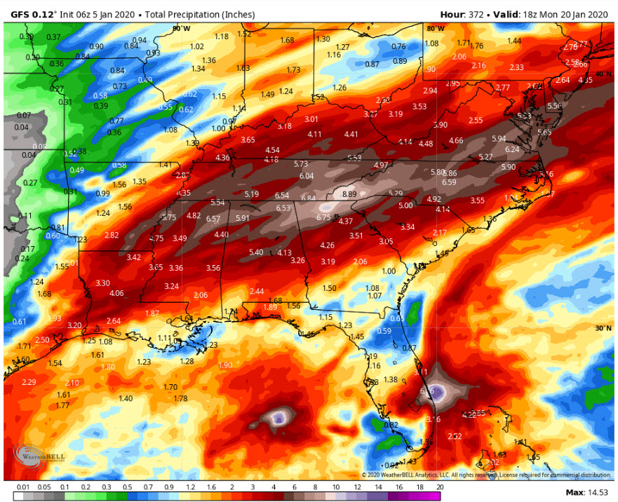
It has been nearly a year since not a single part of Alabama showed abnormally dry of drought on the U.S. Drought Monitor. Every part of the state now is flush with short term lawn and crop moisture. And another 4-6 inches is likely over the next two weeks, or so says the GFS.
ON THE WEATHER MAPS: A mainly zonal west to east flow covers much of the United States this morning, bookended by a departing trough along the East Coast and an arriving trough along the West Coast. At the surface, A ridge of high pressure covers the Southeast. A trough is moving through Minnesota and the Upper Midwest. Winds will be gusting to 65 mph today across eastern North Dakota and western Minnesota. Strong high pressure covers the Rocky Mountains. This setup is producing fine weather for Alabama.
COLD START TO YOUR SUNDAY: Temperatures are chilly under clear skies across Alabama this morning. Readings are in the upper 20s to lower 30s across the northern two-thirds of the state. Expect near total sunshine today, although increases in moisture will cause some clouds to return late this evening. Highs this afternoon will top out in the middle and upper 50s. Lows tonight will be in the 30s.
THE WEEK AHEAD IN ALABAMA: Monday will see that trough in the Midwest reaching its tentacles down through the Mississippi Valley and swiping through toward Alabama. Monday will be partly cloudy with highs in the lower and middle 60ss. Clouds will thicken Monday night as the trough passes through and a few showers will break out. Rainfall amounts will be light. It will be a little breezy during the overnight hours Monday night with the low-pressure passing. The showers will exit Northeast Alabama Tuesday morning and skies will clear with highs in the 50s again. High pressure will be large and in charge Wednesday with highs in the upper 50s. Thursday will see the high slide to the east with a return flow of moisture from the Gulf. A few showers could show up Thursday night, but the main rain event will come Friday.
WET WEEKEND: rain will increase through the day on Friday and become heavy at times Friday night. Widespread 2-3 inch amounts are likely again over the northern half of the state. It will be warm though, with highs in the upper 60s.
SEVERE THREAT? The SPC has parts of the South outlooked for severe weather Friday and Saturday, starting in the Arklatex Friday and Friday night and spreading into Alabama and Mississippi on Saturday. Timing and threat details will come into closer focus as we go through the week, but this is on the table now.
NEXT RAIN CHANCE will follow on the next Tuesday and Wednesday. It looks like another 2-3 inch amount.
VOODOO TERRITORY looks boring. Look for a passing front to bring showers on Tuesday the 21st.
GULF COAST WEATHER: Most of the week ahead will be beautiful along the beautiful beaches of Alabama and Northwest Florida. Highs will be in the 60s through Thursday with lows in the 40s and 50s. Friday and Saturday will be warmer, with highs in the 70s, but wet with showers and storms. Water temperatures are running around 62F. Click here to see the Beach Forecast Center page.
WEATHERBRAINS: This week, the panel will entertain Friend of the Show Tim Brice, who will be talking about NWS Educational Outreach. Check out the show at www.WeatherBrains.com. You can also subscribe on iTunes. You can watch the show live at live.bigbrainsmedia.com You will be able to see the show on the James Spann 24×7 weather channel on cable or directly over the air on the dot 2 feed.
ON THIS DATE IN 2010: Heavy rains fell across North Central Alabama between January 5-7. The most rain fell from Walker County to Etowah County, where up to seven inches of rain was reported. A bingo hall was flooded in Walker County on the night of the 6th, requiring the rescue of 70 stranded patrons. 18 cars were submerged. While the flooding was a disaster for some people, overall, the rains were very welcome, with rainfall deficits still in place in many Alabama counties. Rain kept coming all year. Follow my weather history tweets on Twitter. I am @wxhistorian at Twitter.com.
Category: Alabama's Weather, ALL POSTS
About the Author (Author Profile)
Bill Murray is the President of The Weather Factory. He is the site's official weather historian and a weekend forecaster. He also anchors the site's severe weather coverage. Bill Murray is the proud holder of National Weather Association Digital Seal #0001 @wxhistorianSubscribe
If you enjoyed this article, subscribe to receive more just like it.


