

Not Too Bad At Midday; Enhanced Risk Continues For Central Alabama On Saturday
NO PROBLEMS FOR TODAY
While we will remain dry throughout the day during the day, we will have some clouds move in across the area. As of 11:00 am, skies are mostly sunny to partly cloudy with temperatures in the mid-50s to the lower 60s. We’ll get up into the lower 60s to right at 70 degrees from north to south across the area for afternoon highs. Clouds will continue to move into the area during the evening and overnight hours, and we could see a few showers in the northern and northwestern parts of the area before sunrise. Lows will be in the lower to mid-50s for most.
SPC HAS MUCH OF CENTRAL ALABAMA IN AN ENHANCED RISK FOR SATURDAY
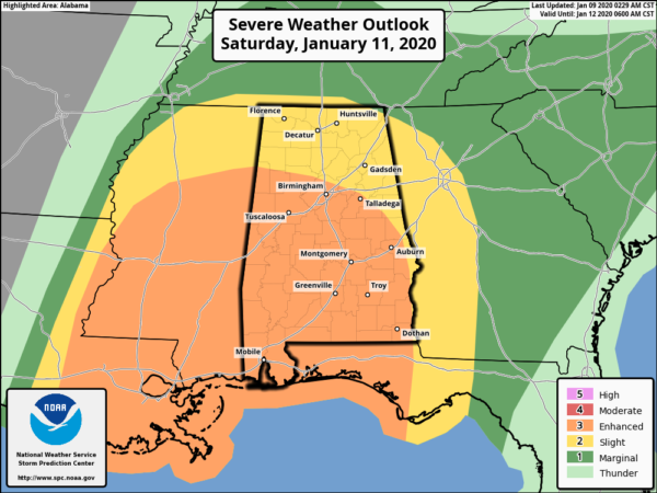
The Storm Prediction Center has much of Central Alabama in an Enhanced Risk (level 3 of 5) for severe storms throughout the day on Saturday for locations south of a line from Sulligent (Lamar Co.) to Clay (Jefferson Co.) to Talladega (Talladega Co.). The rest of Central Alabama (level 2 of 5) is in a Slight Risk for Severe Storms. Severe thunderstorms capable of damaging winds and tornadoes are expected on Saturday.
Don’t get caught up in the risk levels across the area. The potential is high for damaging winds (pre-storms and within the storms) along with a few tornadoes for all of the area on Saturday. Please be prepared and stay weather aware.
NWS BIRMINGHAM CONTINUES ENHANCED RISK FOR CENTRAL ALABAMA ON SATURDAY
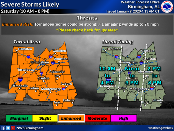
NWS Birmingham continues an Enhanced Risk for severe storms across all of Central Alabama throughout much of the day on Saturday, with the timing being adjusted from 10:00 am to 8:00 pm. It may be pushed back a little later on the start time as models continue a trend of the system arriving a little later. Tornadoes and damaging winds up to 70 MPH will be possible. We’ll also have to deal with rather strong pre-storm winds that could reach as high as 40 MPH at times.
The threat for strong to severe storms for the western-third of the area (west of a line from Addison in Winston Co. to Coaling in Tuscaloosa Co. to just west of Orrville in Dallas Co.) will be from 10:00 am to 4:00 pm. The central-third (east of that to a line from Glencoe in Etowah Co. to Eclectic in Elmore Co. to Goshen in Pike Co.) will be from 12:00 pm to 6:00 pm. The eastern-third (east of that to the AL/GA state line) will be from 2:00 pm to 8:00 pm.
While much of the action with the threat of damaging winds and a few spin-up tornadoes will be in the main squall line as it moves through the area, we’ll have to watch for the potential of supercells forming out ahead of the line in the warm and unstable air. The main threat timing for those supercells should start around 12:00 pm and go through the remainder of the afternoon and evening hours.
Most models have kept the instability in a lower range for this event, but NWS Birmingham thinks that they have been underplaying the amount of instability that will form with the main heating of the day. As we get a few more model runs in, better timing and threat levels will be updated for Central Alabama. If the instability comes in higher, there may be an upgrade to a Moderate Risk for portions of Central Alabama.
Watches that will be issued from the Storm Prediction Center will more than likely be tornado watches.
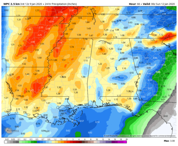
Projected 24-hour rainfall totals ending at 12:00 am Sunday.
While there will be some heavy rainfall amounts with this system, most locations should be able to tolerate it and the potential for flash flooding will be very low at this point. We could see anywhere from as low as 0.75 inches to nearly 1.75 inches across the area, with the much heavier amounts falling over portions of Mississippi, Arkansas, Louisiana, and up into Missouri.
TECHNICAL LOOK INTO THE LATEST MODEL RUN (12z NAM 3K)
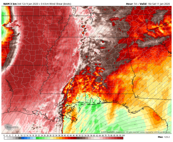
Shear valid at 12:00 pm.
Vertical Wind Shear shows the change in wind throughout a certain height of the atmosphere (surface to 6 km). Supercells are usually associated with values of 35-40 knots and greater. With this run, we are seeing wind shear values in the 40-70 knot range, well more than supportive of supercells. Those values will continue to be that high at 4:00 pm ahead of the squall line.
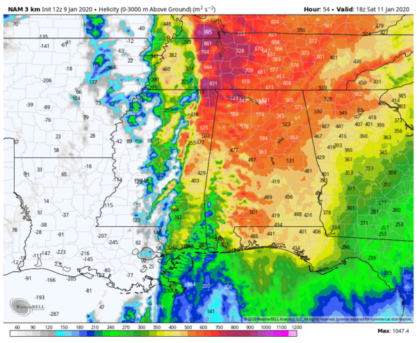
Helicity valid at 12:00 pm.
Storm-Relative Helicity measures the potential for rotating updrafts in a supercell. Any values greater than 250 m2/s2 suggest an increased threat of tornadoes with supercells. With this run, helicity values are forecast to be on the 400-750 m2/s2 range at 12:00 pm, so the increased threat of tornadic supercells will be there. Those values will continue to be that high at 4:00 pm ahead of the squall line.
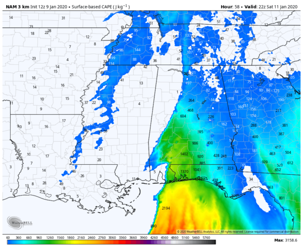
CAPE valid at 4:00 pm.
Surface-Based Instability (CAPE) is a measure of instability (potential energy available) to lift air parcels from the surface through the troposphere (the lowest level of the atmosphere). The higher the number, the more potential energy is available. At noon, the instability is very weak across Central Alabama for the most part, but as we get later into the afternoon, those values will increase to the 400-900 J/kg range along and south of I-20 around 4:00 pm.
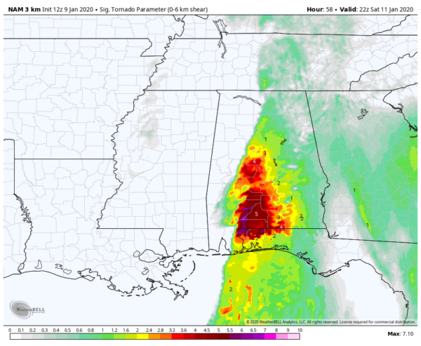
STP valid at 4:00 pm.
Significant Tornado Parameter (STP) is a composite index that combines multiple ingredients to determine a risk value on a 0-10 scale (0 = no risk, 10 = highest risk). A majority of significant tornadoes (EF2 or greater in damage) have been associated with values greater than 1. Most non-tornadic supercells have been associated with values less than 1. At 12:00 pm, STP values in the 1.0-4.0 range in the western parts of Central Alabama and back over into Mississippi. At 4:00 pm, values will be in the 1.0-5.0 range along and west of the I-65 corridor in the southern half of the area, with values reaching as high as 6.5 just south of the area.
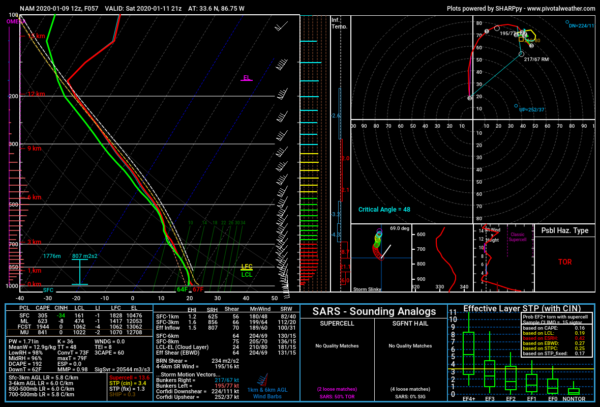
Simulated sounding valid at 3:00 pm.
Simulated 3:00 pm Sounding
This is a simulated sounding valid at 3:00 pm for the Birmingham-Shuttlesworth Airport off of the 12z run of the NAM 3k. It backs up the readings from the above ingredients.
SHEAR: 66 knots
HELICITY: 856 M2/S2
CAPE: 305 J/kg
STP: 3.4
While those instability values are rather low, it doesn’t take much to get severe storms with this type of high shear/high helicity event. As mentioned earlier, the models may be underplaying the instability, so actual values may be much greater. The forecast CAPE in this sounding shows a value of 1,944 J/kg. That may be too high, but I could see values approaching 1,000 J/kg or a little higher with this setup. Therefore, damaging winds up to 70 MPH and a few tornadoes are possible.
BOTTOM LINE

All of Central Alabama is in a threat for severe weather on Saturday and now is the time to be prepared. Have multiple ways to receive warnings when they are issued (WEAs, apps, NOAA WeatherRadio, etc.). Go ahead and have your emergency supplies kit ready along with your place of safety. If in a mobile or manufactured home, determine where you will need to ride out this event. DO NOT ride out a tornado warning in a mobile or manufactured home. This is not an April 27, 2011 setup, but all it takes is for one tornado to come down your street to make it your April 27th. Updates will continue from now through the event. Stay safe and weather aware.
Category: Alabama's Weather, ALL POSTS, Severe Weather
About the Author (Author Profile)
Scott Martin is an operational meteorologist, professional graphic artist, musician, husband, and father. Not only is Scott a member of the National Weather Association, but he is also the Central Alabama Chapter of the NWA president. Scott is also the co-founder of Racecast Weather, which provides forecasts for many racing series across the USA. He also supplies forecasts for the BassMaster Elite Series events including the BassMaster Classic.Subscribe
If you enjoyed this article, subscribe to receive more just like it.


