Latest Mesoscale Discussion From NWS Birmingham As Of 9:40 AM
Updated for 9 am Special BMX Sounding and analysis of recent mesoscale data.
Watch Update…
A second tornado watch is in effect until 4 pm CST for areas roughly along and west of Interstate 65 along with St. Clair County but not including Montgomery County at this time. The existing tornado watch for 5 northwest counties of Marion, Winston, Lamar, Fayette and Walker remains in effect until 1 pm CST.
Current Situation…
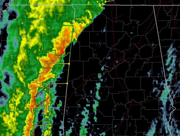
A line of strong to severe storms now extends from Northwest Alabama southwest to east of Jackson, MS. General shower activity was noted on radar across portions of East Mississippi and West Alabama.
Mesoscale Model Initialization and Verification…
Comparing RAP soundings to observations the temperature/dewpoint fields appear to be running about 3 degrees too cold on temperature and around 1 degree too dry for dew points. Adjusting the point forecast soundings at MEI and CBM are indicating much higher instability values than depicted by the model, on the order of 30-50% higher surface-based instability values. This is being exhibited by recent deep convective development ahead of the line in South-Central Mississippi west of Meridian.
Environmental Conditions…
KBMX NEXRAD VAD VWP wind profiler data along with our latest 9 am BMX sounding both indicate a highly sheared environment with 0-1 km Storm relative helicity values from 250-350 m2/s2. Wind shear remains robust and is more than sufficient to support severe storms capable of producing high winds and embedded tornadoes in the line along with in any discrete convection that can develop ahead of the line.
The convective line is being dynamically forced and will pose the broadest concern for high winds. Surface-based instability values are currently the limiting factor for supporting robust development ahead of the forced line of storms.
Higher instability (Surface-Based Convective Available Potential Energy, SBCAPE) values around 500 J/kg per mesonanalysis data was over our far southwest counties and is expected to advance north and northeast with time through mid morning. As aforementioned, our analysis of data shows that these model-derived soundings are running slightly cooler and drier compared to observations and accounting for these issues results in SBCAPE values closer to the 700-1100 J/kg range. As the low-level instability continues to increase and further moistening aloft in the mid levels should help to further steepen lapse rates and reduce the weak capping in place over the area.
So far the stronger isolated cells that have formed ahead of the line have been observed interacting with and being absorbed into the line and then posing a tornado threat. We will be watching the behavior of new deep convection west of Meridian very closely to see how it interacts with the line of storms.
Special Soundings…
We have completed the 6 am sounding and the 9 am sounding will be fully completed soon. We hope to launch an 12 pm sounding if conditions permit locally.
Category: Alabama's Weather, ALL POSTS, Severe Weather
About the Author (Author Profile)
Scott Martin is an operational meteorologist, professional graphic artist, musician, husband, and father. Not only is Scott a member of the National Weather Association, but he is also the Central Alabama Chapter of the NWA president. Scott is also the co-founder of Racecast Weather, which provides forecasts for many racing series across the USA. He also supplies forecasts for the BassMaster Elite Series events including the BassMaster Classic.Subscribe
If you enjoyed this article, subscribe to receive more just like it.


