A Brief Update On Our Weather Just After 2:00 PM
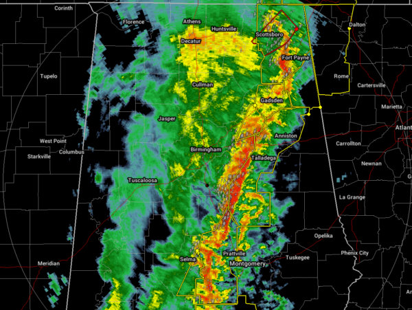
The line of severe storms continues to move eastward through the northeastern, east-central, and south-central parts of North/Central Alabama with the entire line under severe thunderstorm warnings for the threat of damaging winds up to and exceeding 70 MPH and a brief tornado. A Tornado Warning is in effect for parts of Jackson and Marshall counties but should be expiring at 2:15 pm.
There have been plenty of damage reports come in from across North/Central Alabama as the line has passed through several locations, and unfortunately, we have three confirmed fatalities near Carrollton in Pickens County.
If you are still in front of the line of storms and when you go under a warning, no matter if it is a severe thunderstorm or tornado warning, treat it as a tornado warning. The winds are no joke with these storms as the damage has occurred with just winds along with possible tornadoes.
Once the line passes your location, the threat of severe weather is over and you will be left with a little breeze and some lingering showers for a little while.
I apologize for lack of regular updates due to the number of warnings that are being issued. I’ll try to get updates out when I get a free moment in-between warnings.
Category: Alabama's Weather, ALL POSTS, Severe Weather
About the Author (Author Profile)
Scott Martin is an operational meteorologist, professional graphic artist, musician, husband, and father. Not only is Scott a member of the National Weather Association, but he is also the Central Alabama Chapter of the NWA president. Scott is also the co-founder of Racecast Weather, which provides forecasts for many racing series across the USA. He also supplies forecasts for the BassMaster Elite Series events including the BassMaster Classic.Subscribe
If you enjoyed this article, subscribe to receive more just like it.


