CANCELED – Severe T-Storm Warning: Parts Of Cleburne County Until 3:45 PM
BULLETIN – IMMEDIATE BROADCAST REQUESTED
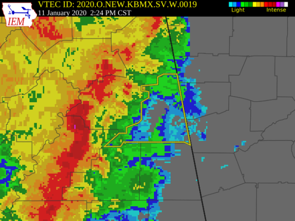
Severe Thunderstorm Warning
National Weather Service Birmingham AL
223 PM CST Sat Jan 11 2020
The National Weather Service in Birmingham has issued a
* Severe Thunderstorm Warning for…
Cleburne County in east central Alabama…
* Until 345 PM CST.
* At 223 PM CST, severe thunderstorms were located along a line
extending from near Alexandria to 7 miles east of Sycamore, moving
northeast at 50 mph.
HAZARD…70 mph wind gusts.
SOURCE…Radar indicated.
IMPACT…Expect considerable tree damage. Damage is likely to
mobile homes, roofs, and outbuildings.
* Locations impacted include…
Heflin, Ranburne, Fruithurst, Edwardsville, Muscadine, Abernathy,
Mars Hills, Mount Cheaha, Hollis Crossroads, Sweetwater Lake,
Coleman Lake And Campground, Trickem, Lake Cleburne, I 20 Welcome
Center, Liberty Hill, Chalafinnee, Oak Level, Borden Springs and
Camp Sequoyah.
PRECAUTIONARY/PREPAREDNESS ACTIONS…
A Tornado Watch remains in effect until 800 PM CST for northeastern
and east central Alabama.
For your protection move to an interior room on the lowest floor of a
building.
Category: Alabama's Weather, ALL POSTS, Severe Weather
About the Author (Author Profile)
Scott Martin is an operational meteorologist, professional graphic artist, musician, husband, and father. Not only is Scott a member of the National Weather Association, but he is also the Central Alabama Chapter of the NWA president. Scott is also the co-founder of Racecast Weather, which provides forecasts for many racing series across the USA. He also supplies forecasts for the BassMaster Elite Series events including the BassMaster Classic.Subscribe
If you enjoyed this article, subscribe to receive more just like it.


