

Rain Today, Dry & Much Colder Tomorrow
So for today, skies will be mostly cloudy with rain becoming likely during the latter part of the morning and will stick with us through much of the day. Rain should be moving out during the evening and late-night hours. No severe weather is expected or any thunder as well. Colder air starts to roll in after rain leaves with the passage of the cold front. Highs will be in the upper 50s to the upper 60s with lows dipping into the lower 30s to the mid-40 from northwest to southeast. Rainfall amounts should be less than 1/2-inch.
Temperatures will be struggling to warm up on Sunday after the cold front passes through late tonight. Skies will be clearing throughout the morning and will be mostly sunny by sunset. Winds will be out of the north at 5-15 MPH, so it will feel much cooler than the actual temperatures. Highs will be in the mid-40s to the lower 50s across the area.
Even though there will be plenty of sunshine on both Monday and Tuesday, Old Man Winter has returned in full force. We’ll start off in the mid-20s to the lower 30s on Monday morning and will struggle to reach the upper 30s to the upper 40s.
Tuesday won’t be much better as we’ll start off in the upper teens to the lower 20s and only reaching the 40s for afternoon highs.
We’ll have some clouds move through the area on Wednesday, but we should remain dry. Skies will be partly to mostly cloudy at times with afternoon highs in the upper 40s to the mid-50s.
Much of the same story for Thursday but we’ll be a touch warmer. There is a very small chance of a shower as we reach the late-night hours, but much of the area will remain dry. Highs will be in the mid to the upper 50s.
A cold front will be approaching Central Alabama to start the day on Friday and will push rain into the area starting after midday. Rain will be likely through the rest of the daylight hours and into the morning hours on Saturday. At this point, no thunder is expected, but we’ll keep our eyes on it through the week. Highs will be in the mid-50s to the mid-60s.
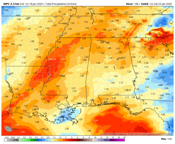
Latest rainfall projections show we could see anywhere from 1 inch to just below 2 inches across much of the area through next Saturday morning.
Category: Alabama's Weather, ALL POSTS, Weather Xtreme Videos
About the Author (Author Profile)
Scott Martin is an operational meteorologist, professional graphic artist, musician, husband, and father. Not only is Scott a member of the National Weather Association, but he is also the Central Alabama Chapter of the NWA president. Scott is also the co-founder of Racecast Weather, which provides forecasts for many racing series across the USA. He also supplies forecasts for the BassMaster Elite Series events including the BassMaster Classic.Subscribe
If you enjoyed this article, subscribe to receive more just like it.


