Showers, Showers, and More Showers Ahead for Alabama
Much of our area experienced clouds for at least part of the day yesterday. In the morning, low-level moisture meant a gray start for many. Even after those burned off, high-level moisture in the 300 millibar level of the atmosphere (around 30,000 feet) caused an impressive deck of cirrostratus and lots of contrails.
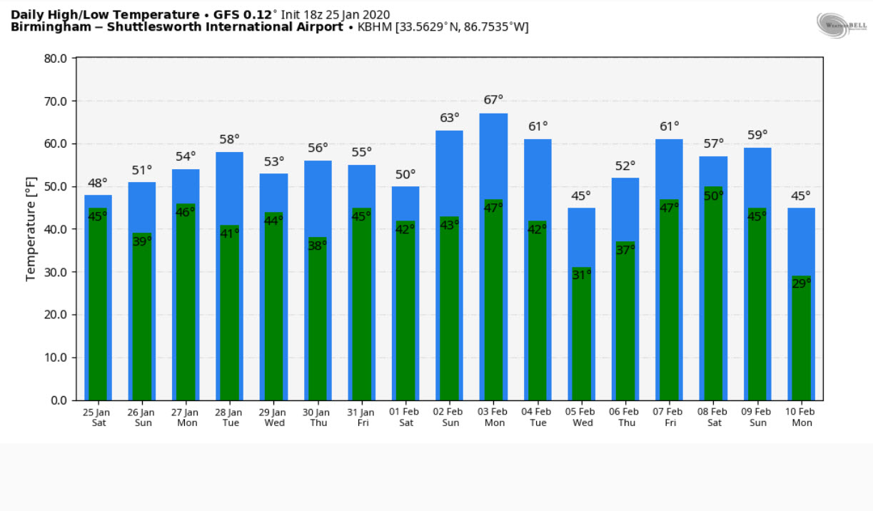
FOR YOUR SUNDAY: In the mid and upper levels of the atmosphere, a broad trough covers the eastern half of the nation. At the surface, high pressure is holding on by its fingernails over Alabama and the Southeast. Lots of moisture will overspread the state at various levels of the atmosphere Everyone is starting off in the 30s this morning. Highs will top out in the 50s, ranging from 52F in Gadsden to 55F in Tuscaloosa to 57F in Montgomery. Skies will become cloudy during the afternoon.
SHOWERS ENROUTE: Some light rain will overspread southern parts of the area this morning and another batch of rain showers will overspread North and Central Alabama this evening and overnight. Rain should move out by sunrise but a little drizzle could persist until mid-morning. Rainfall amounts will be light, around one-quarter of an inch.
MOSTLY CLOUDY MONDAY: Skies will remain mostly cloudy on Monday, and high temperatures will top out in the middle 50s. That is right around normal for this tie of year. They will begin to clear Monday night, with lows in the 30s.
TUESDAY; The day will start off fairly sunny but turn cloudier as we go through the afternoon. Highs will be mild again, in the middle to upper 50s mostly.
MIDWEEK WET WEATHER: Another disturbance will swing through starting Tuesday night, lasting through much of Wednesday. It will spin up a weak surface low over the Gulf of Mexico. Rainfall amounts will be light, and probably a little spotty, averaging less than a quarter of an inch.
THURSDAY RESPITE FROM THE WET: Expect clearing skies Wednesday night to carry into Thursday with a good supply of sunshine. Highs will be in the middle 50s.
MORE END OF THE WEEK WETNESS: Another disturbance and low-pressure system moving across the northern Gulf will bring rain into the state on Friday. The heaviest rain will be late Friday afternoon into Friday evening, with diminishing precip during the day on Saturday. Highs both days will be in the middle 50s. Sunday will feature partly cloudy skies and dry conditions. Highs will be in the lower 50s.
VOODOO WARMUP: We will warm up nicely in the middle and upper 60s by Monday, February 3rd. Things will cool down by Tuesday though and another cold rain will move through that Tuesday.
GULF COAST WEATHER: Rain will be a big part of the weather picture along the beautiful beaches of Alabama and Northwest Florida. It will be a bit milder than here, with highs in the 60s and lows in the 40s. Water temperatures are running around 56F. There won’t be much of a rip current threat in days ahead.
Click here to see the Beach Forecast Center page.
ADVERTISE WITH US: Deliver your message to a highly engaged audience by advertising on the AlabamaWX.com website. The site enjoyed 15.2 MILLION page views in the past 12 months. Don’t miss out! We can customize a creative, flexible and affordable package that will suit your organization’s needs. Contact me, Bill Murray, at (205) 687-0782 and let’s talk.
WEATHERBRAINS: This week, the panel will entertain preparedness expert Dr. Sarah McBride. She has done some amazing work in using storytelling to help people prepare for disasters. Check out the show at www.WeatherBrains.com. You can also subscribe on iTunes. You can watch the show live at live.bigbrainsmedia.com You will be able to see the show on the James Spann 24×7 weather channel on cable or directly over the air on the dot 2 feed.
ON THIS DATE IN 1990: Deteriorating weather caused unsafe weather conditions over New York City as a storm system approached the area. Weather caused air traffic managers to raise landing counts above what some felt were safe levels in order to get planes on the ground. Avianca Flight 52 from Medellin, Columbia ran out of fuel while in a holding pattern and crashed on Long Island. The failure to communicate the flight’s critically low fuel status during a handoff from controller to controller resulted in a lack of priority for the landing. As the plane was cleared for final approach, low-level wind shear forced the plane toward the ground. The crew had to abort the approach at 200 feet and 2 miles away from the runway. Handed off to another controller meant communicating the emergency again. Language issues also contributed to the disaster since the pilot spoke poor English and most communication had to be handled through the First Officer. As the second approach, the Boeing 707’s engines began to fail. The jet crashed into the town of Cove Neck, Long Island. A total of 73 of the 158 passengers and crew that were on the plane died in the crash. The lack of fire because the plane was out of fuel probably saved many lives of survivors. Follow my weather history tweets on Twitter. I am @wxhistorian at Twitter.com.
Category: Alabama's Weather, ALL POSTS
About the Author (Author Profile)
Bill Murray is the President of The Weather Factory. He is the site's official weather historian and a weekend forecaster. He also anchors the site's severe weather coverage. Bill Murray is the proud holder of National Weather Association Digital Seal #0001 @wxhistorianSubscribe
If you enjoyed this article, subscribe to receive more just like it.


