Cloudy, Cool Saturday Afternoon
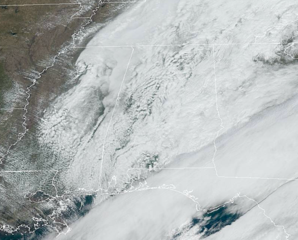
The upper trough continues to swing across the state this afternoon, and though we had some morning showers, most of those have since pushed off towards the south and east. It remains mainly cloudy, with some peeks of sunshine, but for the most part it stays cloudy the rest of today as the clearing line remains back in northwest Mississippi.
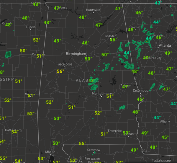
Temperatures remain chilly with upper 40s and lower 50s.
As we head into the overnight hours, the sky will gradually clear as northwest flow drives drier air into the state. Lows by first thing tomorrow morning will be in the upper 30s across North/Central Alabama.
SUN-FILLED SUNDAY: Tomorrow will be the pick of the litter day of weather for the weekend. The sky will have ample sunshine tomorrow, and all that sunshine will allow temperatures to warm well into the 60s tomorrow afternoon. With a sunny day expected, unfortunately that would mean “Birmingham Bill” would see his shadow, meaning six more weeks of winter, however, the Birmingham Zoo this week said Birmingham Bill is still hibernating and would not be making his annual prognostication this year. Sunday night will be mostly clear with lows in the lower to mid 40s.
MONDAY/TUESDAY: Monday will be a spring-like day, with a mix of sun and clouds with a high around 70 degrees. Clouds begin to increase Monday night, and we will bring in the chance of showers Tuesday and Tuesday night ahead of an approaching cold front. Tuesday itself should feature showers at times with highs in the upper 60s.
STORMY WEDNESDAY: As the front approaches Alabama we should see a surface low develop along the Gulf Coast and lift north along the front across the Southeast, which along with an unstable air mass in place, will increase the wind fields. This will allow for some strong to perhaps severe storms to develop and impact Alabama. As of now, the SPC has included nearly all of Alabama in a threat for severe weather Wednesday and Wednesday night.
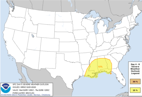
At this point, damaging winds and a brief tornado or two may be possible, but still this is five days out, and a lot can and will change in the coming days. We will just watch trends in the coming days and we will have a better idea of the overall situation when the higher-resolution and convection-allowing models come into view early in the week. So for Wednesday, expect a warm and stormy day with highs again close to 70 degrees
BEACH FORECAST CENTER: Get the latest weather and rip current forecasts for the beaches from Fort Morgan to Panama City on our Beach Forecast Center page. There, you can select the forecast of the region that you are interested in visiting.
WORLD TEMPERATURE EXTREMES: Over the last 24 hours, the highest observation outside the U.S. was 116.2F at Richmond Amo Aws, Australia. The lowest observation was -65.7F at Delyankir, Russia.
CONTIGUOUS TEMPERATURE EXTREMES: Over the last 24 hours, the highest observation was 86F at Santa Ana, Lake Forest, and Roblar Canyon, CA. The lowest observation was -6F at Knowles Corner, ME.
WEATHER ON THIS DATE IN 1893: Thunder and lightning accompanied sleet and snow at Saint Louis MO during the evening hours, even though the temperature was just 13 degrees above zero.
ABC 33/40’s Storm Spotter Training
The Annual ABC 33/40 Storm Spotter Training will take place at the Hoover Met on Saturday, February 8th starting at 9:30 am, with doors opening as early as 8:45 am. There is no cost and no need to register. Just show up with a curious mind. There will be a basic class and an advanced class. James Spann will even be speaking during the downtime between classes. A complete schedule will be coming out soon. Keep an eye on Spann’s Facebook page for updates.
NWS Birmingham SKYWARN Storm Spotter Training
The National Weather Service office in Birmingham will be offering several online Basic Spotter Courses and a single Advanced Spotter Course over the next few months. These online courses are FREE and are open to anyone who would like to learn more about what it takes to be a spotter and what to look for. More information can be found on the NWS Birmingham’s website, just CLICK HERE to visit the site.
Category: Alabama's Weather, ALL POSTS
About the Author (Author Profile)
Macon, Georgia Television Chief Meteorologist, Birmingham native, and long time Contributor on AlabamaWX. Stormchaser. I did not choose Weather, it chose Me. College Football Fanatic. @Ryan_StinnetSubscribe
If you enjoyed this article, subscribe to receive more just like it.


