Severe Threat Continues To Our West; Need To Watch Western Parts Of The Area
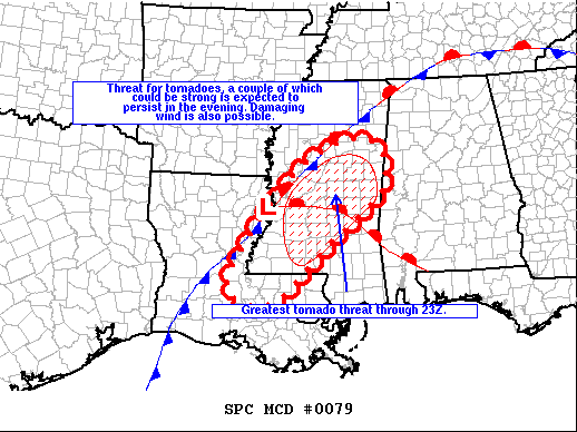
From the latest SPC Mesoscale Discussion…
The severe weather threat for Tornado Watch 22 (parts of Louisiana and Mississippi) continues.
SUMMARY
The threat for tornadoes has undergone a significant increase during the past hour from the southwest through central MS, and this threat is expected to persist into the evening including the potential for a couple of strong tornadoes.
DISCUSSION
Storms have undergone a significant increase in organization during the past hour. A couple of storms with a history of producing tornadoes persist from southwest through central MS. Activity is increasing east and southeast of a surface low that will deepen and track northeast along a stationary front this evening. Large low-level hodographs with 300-400 m2/s2 0-1 km storm-relative helicity exist along a strengthening low-level jet and within a moderately unstable environment. Additional storms developing in the warm sector will likely organize as supercells and bowing segments with an attendant threat for tornadoes and damaging wind.
Category: Alabama's Weather, ALL POSTS, Severe Weather
About the Author (Author Profile)
Scott Martin is an operational meteorologist, professional graphic artist, musician, husband, and father. Not only is Scott a member of the National Weather Association, but he is also the Central Alabama Chapter of the NWA president. Scott is also the co-founder of Racecast Weather, which provides forecasts for many racing series across the USA. He also supplies forecasts for the BassMaster Elite Series events including the BassMaster Classic.Subscribe
If you enjoyed this article, subscribe to receive more just like it.


