Severe Storms/Flooding Possible Tonight
**No afternoon Weather Xtreme video today**
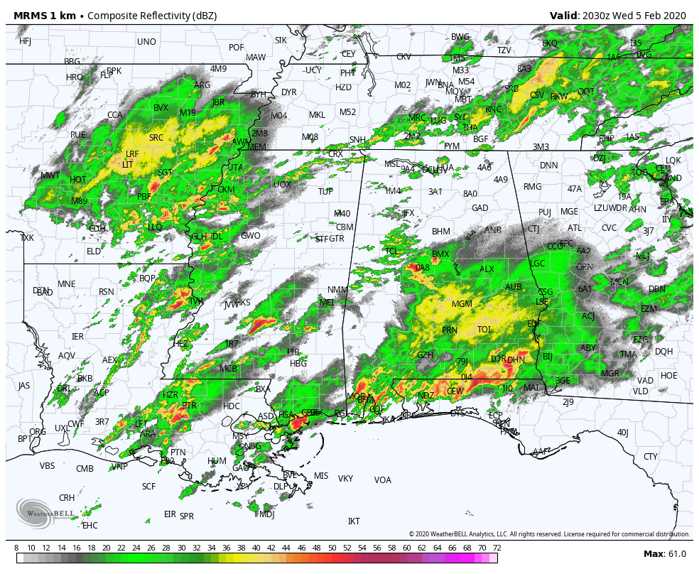
THIS AFTERNOON: A few stronger storms have formed over Central Alabama, producing small hail through parts of Hale, Bibb, Jefferson, and Shelby counties. The storms as I write this are still well below severe limits. To the south, a larger mass of rain and storms is over much of South Alabama.
A complex setup continues for tonight; it remains to be seen what the ongoing convection across Alabama will do to the thermodynamic environment; there is optimism that it will disrupt instability potential, and limit the overall severe weather threat tonight. However, that certainly can’t be guaranteed with a dynamic system approaching with strong wind fields.
SPC maintains an “enhanced risk” (level 3/5) of severe storms for a part of Northwest Alabama, and a “slight risk” (level 2/5) for most of the rest of the state through tonight.
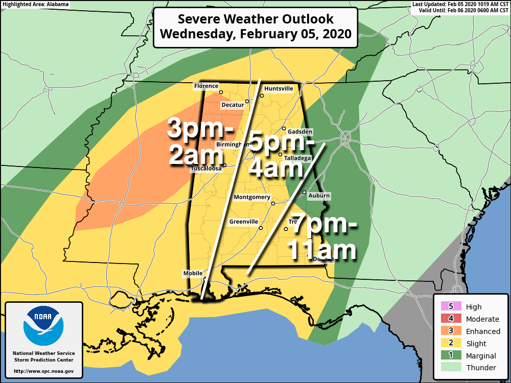
TIMING: The core severe weather threat for the state will come tonight, although an isolated severe storm can’t be ruled out between now and sundown. The threat will end from west to east after midnight, but parts of Southeast Alabama will have a lingering threat through 11:00 a.m. tomorrow (places like Dothan and Ozark).
THREATS: Stronger thunderstorms tonight will be capable of producing small hail, damaging winds, and a few tornadoes. A strong tornado (EF-2 or higher) can’t be ruled out in the “enhanced risk” area across Northwest Alabama.
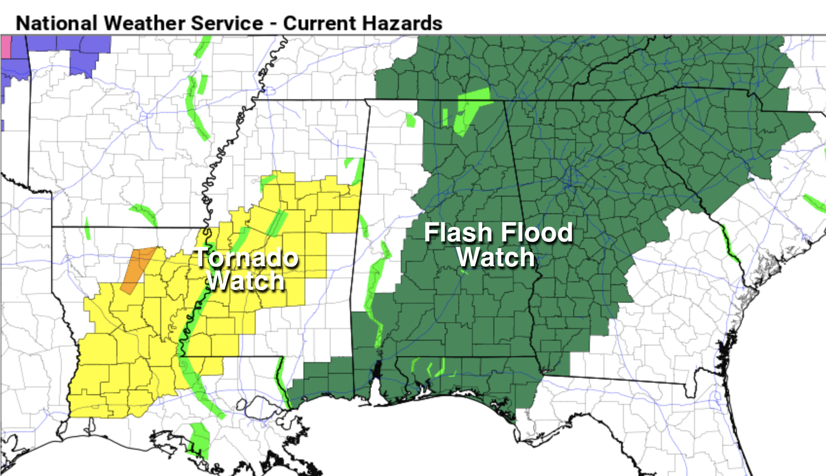
FLOODING: Rain amounts of around three inches are likely between now and tomorrow night, and a flash flood watch remains in effect for much of Alabama.
CALL TO ACTION: Be sure you have a good way of hearing severe weather warnings tonight if they are needed. Know your safe place, and have helmets for everyone there. And, if you live in a mobile home, understand you can’t stay there during a tornado warning. Know where you are going, and the quickest way to get there.
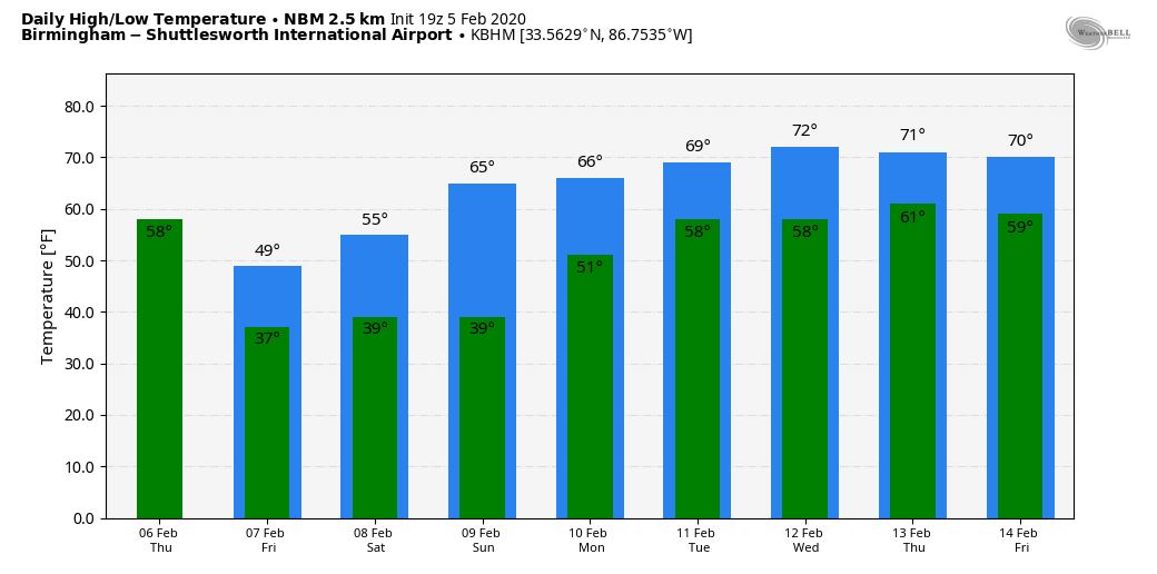
TOMORROW/FRIDAY: Rain continues tomorrow, but temperatures will go the wrong way. We start the day in the 60s during the early morning hours, but then we fall through the 50s, most likely reaching the 40s by afternoon. It will feel much colder than the recent warmth. Rain finally tapers off tomorrow night as drier air pushes into the state.
There could be just enough moisture left over for a few snow flurries over the northern third of Alabama late tomorrow night and Friday morning, but we expect no impact. Then, during the day Friday, look for partial clearing with a high close to 50 degrees.
THE ALABAMA WEEKEND: Clouds move back into the state Saturday with a fast moving weather disturbance, and some scattered light rain is possible during the day. Nothing heavy, no thunder. Rain amounts should be under one tenth of an inch… and the high will be in the mid 50s. Sunday promises to be a very nice day with ample sunshine along with a high around 60 degrees.
NEXT WEEK: Clouds increase Sunday night, and we expect mild conditions with periods of rain Monday and Tuesday… highs will be up in the 60s. Then, a cold front will bring thunderstorms Wednesday; too early to know if severe thunderstorms will be an issue. We trend drier toward the end of the week… See the Weather Xtreme video for maps, graphics, and more details.
ON THIS DATE IN 2008: The Super Tuesday 2008 Tornado Outbreak has been one of the deadliest tornado outbreaks in the US with 59 fatalities reported. So far, it ranks in the top 15 deadly tornado outbreaks. According to the SPC Storm Reports, there were over 300 reports of tornadoes, large hail (up to 4.25 inches in diameter in Texas, Arkansas, and Missouri), and damaging wind gusts from Texas to Ohio and West Virginia. The outbreak produced at least 64 tornadoes, some producing EF-3, and EF-4 damage. There were seven tornadoes in Alabama, including an EF-4 they moved through parts of Lawrence and Morgan counties, killing four people. Another EF-4 tornado touched down in Jackson County, near Rosalie, killing one person.
STORM SPOTTER TRAINING: Our annual storm spotter training is this Saturday, February 8 at the Hoover Met. It begins at 9:30; and there is no cost. We will offer both the basic and advanced training sessions… we expect to wrap up by 2:30. No need to register; just show up with a curious mind. We need more trained storm spotters! Help us make the warning process better!
BEACH FORECAST: Click here to see the AlabamaWx Beach Forecast Center page.
WEATHER BRAINS: Don’t forget you can listen to our weekly 90 minute show anytime on your favorite podcast app. This is the show all about weather featuring many familiar voices, including our meteorologists here at ABC 33/40.
CONNECT: You can find me on all of the major social networks…
Facebook
Twitter
Instagram
Pinterest
Snapchat: spannwx
Look for the next Weather Xtreme video here by 7:00 a.m. tomorrow…
Category: Alabama's Weather, ALL POSTS
About the Author (Author Profile)
James Spann is one of the most recognized and trusted television meteorologists in the industry. He holds the AMS CCM designation and television seals from the AMS and NWA. He is a past winner of the Broadcast Meteorologist of the Year from both professional organizations.Subscribe
If you enjoyed this article, subscribe to receive more just like it.


