Threat Of Severe Storms Will Be Increasing Over The Next Few Hours
As just posted in the latest Mesoscale Discussion from the Storm Prediction Center, the strong to severe activity that is located in Central Mississippi has been increasing in intensity over the past hour. These storms are expected to move into the northern half of Central Alabama and into North Alabama within the next several hours.
The environment across the northern and western parts of the area is starting to become more favorable for strong to severe storms. We continue to see the threats of tornadoes and damaging winds in excess of 60 MPH possible, with a strong tornado possible as well. Large hail of 1-inch in diameter will also be possible.
SPC will be talking it over with both the Birmingham and Huntsville offices of the National Weather Service about the location and length of time for the upcoming TORNADO WATCH that should be issued within the next 1-2 hours.
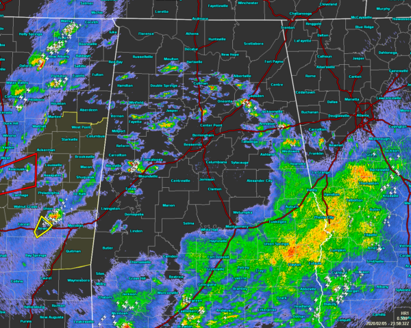
Nothing too impressive on the radar as of 4:00 pm across the area. We have scattered showers and thunderstorms over the northern half of the area with a more pronounced rain shield over the extreme southern and southeastern parts of the area.
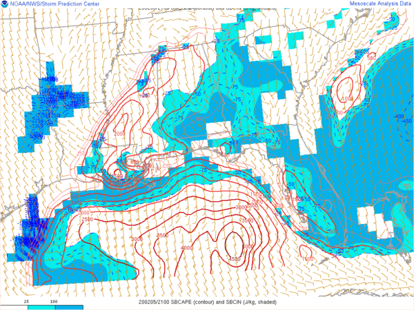
Instability is increasing over the western and northwestern parts of the area, as values are now up to and exceeding 500-1000 J/kg. It doesn’t take much instability with these winter-type systems to have severe storms and these values are more than sufficient for severe storms to occur.
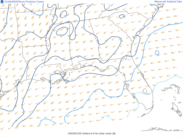
Shear is really high at this point across all of North/Central Alabama as values are exceeding 60-70 knots. Severe storms and supercells are usually associated with values of 35-40 knots, so we are well above that threshold.
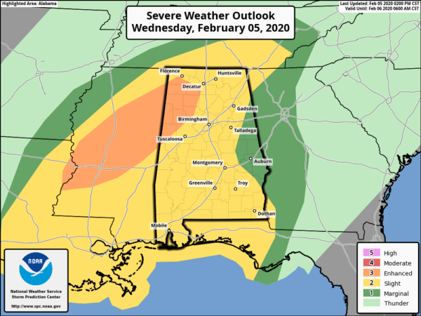
We’ll have to really watch the western half of the area really from now through the rest of the evening hours, especially in the Enhanced Risk locations. That time window for strong to severe storms will be from now through 2:00 am Thursday morning for the western parts of the area, 5:00 pm this evening to 4:00 am Thursday for the central parts of the area (I-65 and I-59 corridors), and 7:00 pm this evening through 10:00 am Thursday morning for the extreme eastern and southeastern parts of the area.
Don’t forget, we’ll have a second wave of more organized storms that will move in after midnight that will also have a threat of damaging winds and a few tornadoes. That will last through much of the morning hours on Thursday.
We’ll continue to keep you updated through the night and overnight hours. I’ll be with you through 7:00 pm before handing it off to Bill Murray for a little while. I’ll be back around 1:00 am to take you through the rest of the event.
Category: Alabama's Weather, ALL POSTS, Severe Weather
About the Author (Author Profile)
Scott Martin is an operational meteorologist, professional graphic artist, musician, husband, and father. Not only is Scott a member of the National Weather Association, but he is also the Central Alabama Chapter of the NWA president. Scott is also the co-founder of Racecast Weather, which provides forecasts for many racing series across the USA. He also supplies forecasts for the BassMaster Elite Series events including the BassMaster Classic.Subscribe
If you enjoyed this article, subscribe to receive more just like it.


